[from Proc IoMNH&ASoc vol2 #1 1923]
[Leader: Mr. P. M. C. Kermode.]
The 10th October proved another fine day, and thirty-two, members, with about thirty visitors, enjoyed an Excursion, of which Mr. Kermode acted as Leader.
Cars were awaiting the arrival of the morning train in Ramsey, and the party drove to Ballakillingan, where they were received by Mrs and Miss Farrant. The leader pointed out the site of the old Keeill of S. Ninian, from which the estate derives its name, as marked on the Ordnance Survey, being at the end of a row of trees about 200 yards E.S.E. of the house and 66 yards N. of the highroad; as this site had been favoured by the late Mr. E. Farrant, he thought that, in the absence of evidence to the contrary, they might accept it as correct.
At the entrance to Skyhill the cars were left, and the old Park ny earkan (Plover Park) road was followed for some distance. Views were obtained of the low-lying land, the river and the Mooragh, and a discussion was started on the subject of the famous battle of Scacafell, as a result of which Godred Crovan, son of Harold the Black, of Islay, who had twice failed in previous attempts, established himself on the throne of his ancestors. Canon Quine being invited to give an account of this engagement, pointed out that the Mooragh, as shown by the Manorial records, had, even 400 years ago, constituted the Quarterland of Ramsey, of perhaps 60 acres, and he argued that, in the eleventh century, it must have been an island, of still greater area, the river flowing out by its northern end and branching across what is now the Market Place and Church Street to the ford at the Old Cross. He supposed that on landing Godred would have been met, and that the engagement was fought on this island, the 300 men of the ambuscade mentioned in the Manx Chronicle having come down from Scacafell to the ford and cut off the retreat of the native forces, which thus became surrounded on all sides.
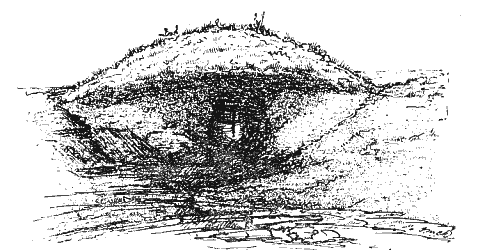
On arrival at the summit of the hill it was found that several of the party had gone there direct, and that many of the local residents had come to learn the results of the excavations which had been made.. The Leader conducted them to the remains of a structure marked on the Ordnance Survey as the.'ruins of a chapel '; but the excavations proved that it could never have been a Keeill. The foundations remained, evidently in their original, enclosing an area, oval in form, lying approximately E. and W., and measuring internally 15ft. by 12ft 6in. A recent entrance had been formed at the N.E., but the position of a stone set on end and a space of 2ft. 6in., filled in with earth, seemed to mark the original entrance at the S.W.; the walls, about 3ft. 6in. high, were substantially built of fairly large stones. About half a dozen surface slabs, 2ft. 6in. to 3ft. long and 4 to 6in. thick; the rest quartz boulders with surface stones up to 12in. and 18in. diameter, in rough courses, on either side of a core of rubble, and banked up outside with soil, strengthened with stones. In thickness the wall was about four feet. It had a N.N.W. aspect, and was in a sheltered position at the head of a slight hollow, commanding a view over the whole of the northern plain. He had excavated the whole of the interior to the original undisturbed soil, and, at the W. end, had discovered traces — reaching to a lower level of about 12in. — of Bronze-age burials in the shape of charcoal, crumbs of calcined bones, and pottery in a very decomposed state; there was no sign o£ a cist, but there had been at least two cinerary urns; two or three white shore-pebbles were met with, and a small polished stone axe-head, chisel-shaped, which was now handed round for inspection. He thought there had probably been early burials all over the hill-top, and, though only two fine tumuli now remained, it was likely that, as had happened on the Barony, Maughold, at Earey Jora, Marown, and elsewhere, many had been demolished. I t was, however, very interesting that the echo of a tradition of these pre-historic burials had reached our time in the name of the rock (about 21yards long) which cropped out about 30 to 40 yards N.E. of this spot. This was the Craig Bouyr, a word meaning literally 'deaf ' (Irish, Bogher), but, in a secondary sense, as in the Cronk Bouyr, Bride, signifying 'dead ', thus giving, in these cases, the Mound and the Rock of the Dead.
Canon Quine, whose view was shared by many present, while agreeing that it certainly had not been a Keeill, felt sure it could not have been designed for a sheep-pen.
Subsequently the leader learned that it had long been regarded locally as a Fort, and, though very small for such purpose, and unsupported by the presence of any other remains of blockhouses or small forts, it seemed, after all, more likely that it was designed for something of the kind. It would have made a sheltered position for watch and ward in historic: times, and, as it commanded the way to Snaefell and the interior, may have been of more importance in pre-historic days.
Fig 1. FORT ON SKY-HILL.
Proceeding south-westwards, the Leader pointed to a spot in the adjacent field, which the Ordnance Survey marked 'Burial-ground '. This he had tested by digging, and found it to be nothing but an outcrop of rock, the site being utilised to deposit field-stones, weeds, and rubbish. Two large tumuli near by were visited; one, measuring about 50ft. across the base and over 6ft. high, appeared to have been undisturbed, but was pretty certain to belong to the Bronze Age; he had heard, but had forgotten from what source, that it was known as Cronk Allisha, or some such name. In the other tumulus a Cinerary Urn, shaped not unlike a large flower-pot, had been exposed by sheep rubbing against it; some ten years previously he and the Rev. W. Morris had succeeded in getting this out, and it was now in the Museum. Further to the S.W., a wall was seen to pass over a conical outcrop of rock called Cronk Crock.
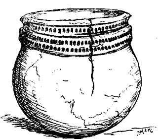
CINERARY URN, FROM CRONK CROCK, SKY-HILL,.
In quarrying to make this wall, another Cinerary Urn had come to light. The mound, about 24ft. in diameter, had been nearly four feet high, but being on the raised rock (some 750 feet above sea-level), had scarcely been noticeable. In Sept., 1883, Dr. Tellet and he had visited it and could trace the outline of the mound, which had been cut in half by the workmen. The urn was then broken, but was seen to rest, mouth upwards, in the rock, in which a hollow about 4in. deep had been made; broken pieces of rock and soil had then been packed around and over it. There was a flat stone over the mouth, but not large enough to cover it. The height was 11in. and outside diameter of the mouth 10½in.; the sides were 1in. thick and the bottom 2in. It was composed of clay with crushed local stone, formed by hand, coarse, heavy, and roughly baked. The Mouth was surrounded by a projecting lip, under which was a row of punctured holes. About 5in from the top a band, slightly raised, encircled the urn; this was 2in. broad, and punctured by two rows of holes similar to those above. The bottom was carefully rounded; the contents had been scattered.
CRONK CROCK, SKYHIL, WITH EXPOSED URN.
Crossing by the old farm buildings on the top of the hill, the southernmost site, marked 'Burial-ground ' on the Ordnance Survey, was visited. Here had been revealed the foundations of a small Keeill, set at the S.E. end of an enclosed cemetery, which measured about 24 yards N. and S. by 10 yards E. and W. Though apparently in a dry situation, there was a remarkable amount of very rough pavement. Three paths had been traced; one from the S., its entrance marked by stones on end, approached by a well-built step, led directly to the doorway of the Keeill; another from the N. had the entrance marked by larger stones on end and by slabs, evidently jamb-stones through the 6ft. thickness of the surrounding fence of earth and rubble; a third path entered the enclosure from the E., and led to a well-formed lintel grave in the centre; this measured about 4ft. by 18in. wide and deep, and bore such an archaic character than Canon Quine suggested it looked like a transition form from the older heathen cists. As to the Keeill itself, the lines of the four walls, from 2ft. 6in. to 3ft. thick, could be. clearly traced, though only two or three courses remained, and most of the facing-stones had been removed, but, at the west end, some of the upright slabs were seen (slipped rather out of position), showing that there had been a skirting of stones on edge, as at Ballakillingan, Marown, and some other early Keeills. A few white pebbles had been met with. The field was known as Magher ny hoarn, which, the Leader thought, might be a pronunciation of the word ooigyn, signifying graves '. Mrs Farrant having accompanied the party, he took the opportunity of expressing the thanks of the Society to her and her tenant, Mr. R. S. Corlett, for having allowed this careful examination to be made. It was encouraging that their efforts to learn something of the history and conditions of life of their forefathers 1,300 years ago, or more, should be met in such a friendly fashion. Canon Quine assured Mrs Farrant that the Society agreed with these remarks and felt indebted to her; he thought that, in some respects, this was the most interesting of these relics he had seen.
This has been described in the Fourth Report of the Archaeological Survey
Crossing to the S.W. corner of the field, a steep descent was made along sheep-tracks into Glen Gowanagh (glen of the yearlings), where they were met by Mr. Pallister, who pointed out the larch plantation he had been making; here a woodcock was flushed, but there were no cameras to take a shot at him. This opened into the main glen at the Derry, a little north of the great slab of diabase and grit known as Clagh ny dooinev marroo, about which a gruesome tale is told. Turning northwards, dozen the glen, a halt was called at the little croft on Ballagarrow, which, in its queer-sounding name, 'Keeill Phooigyn,' or phooigynagh, carried the traditions of another early Keeill. This word may have some relation to the Irish word for a 'Fuller,' and have been applied after the Mill had been established and the cottage occupied by that official; the saint's name attached to the original Keeill having been lost. He did not agree with Canon Quine's suggestion, that the first syllable — as in Fogoghe, Peel, — meant 'below ', from its having been set at the foot of a hill. At the meeting of the streams, the Eastern glen was entered, and a visit paid to the ' old church ' on Ballameanagh. Mrs Cubbon remembered when this was known as the 'Cabbal '; an uncle of hers had, unfortunately, cut a road-way right through the building, and, in doing so, had come across a bone needle and some rings, which were now lost. The S.W. corner of the building remained, and showed how the walls, 3ft. thick, had been supported by a bank, strengthened with stones, and flagged on the top so as to carry off the rain. A fine example of a stone-lined grave, exposed in this roadway , must have been directly under the north wall of the Keeill; it measured over 6ft. long, and was evidently of early date. Canon Quine remarked upon a large notch cut in the south side stone, reminding him of prehistoric graves in which openings were sometimes left for the insertion of urns or of offerings An interesting thing about this Cabbal was that in the old days people used to come here to watch at midnight of S. John's Eve, in order to divine how many of the inhabitants were to pass away during the ensuing year.
Following the old road on the south side of the stream, the Lageeil, in Glion Keeill Vael, was next visited; no trace of it was now visible, though possibly when the field was ploughed there might still be some indication of it; in any rase, it was most interesting to have found another dedication to S. Michael in such an unlooked for spot.
Seats were now resumed for a drive to Riversdale, where the party was hospitably entertained by the Misses Rudd.
MEETING.
After tea and a short stroll in the grounds, a Meeting was held, the Rev. J. Davidson, President, in the chair. Mr. J. R. Connall, J.P., Port St. Mary, and Mrs Connall, were elected members, and six nominations were handed in. Five additions to the Library were announced. Among communications, a letter from Mr. L. Mann asked whether any of the 'blunt-nosed chisels ' had been found in the Island, such as were met with in the Oban caves. A typical example of one of these had been sent for inspection, and members were asked to be on the look-out for them round the coast. Mr. Lace exhibited a sword from, Foxdale, which he intended to present to the Museum. Votes of thanks to the Leader and Canon Quine, and to the Misses Rudd for their kindly reception, brought the meeting to a close.
|
|
|
|
|
|
||
|
Any comments, errors or omissions
gratefully received MNB
Editor |
||