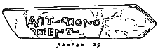
Fig 37. Santan. A seventh century Latin inscription 'Avit Monoment'
[From 5th Report - 1918]
TO THE ISLE OF MAN NATURAL HISTORY AND ANTIQUARIAN SOCIETY.
Fifth Report of the Manx Archaeological Survey.
Six Keeills are known to have been in this parish, most of the foundations existing until quite recent times, and it is thought there may have been another. The Parish Church also is almost certainly on the site of an ancient Keeill, the dedication of which is commemorated in its name. Only one now shows any remains.
(1) Ruins of Keeil on the Quarterland of Sulbrick, Treen of Sandbrick. [4° 35' 18" W.; 54 8' 18" N.]
(2) Possible site of Keeill on Quarterland of Ballavartin, Treen of Knock a Loughan. [4° 33' .58"' W.; 54 7' 46" N.]
(3) Site of Keeill on Ballavale, Quarterland of Ballahowin, Treen of Bendovle. [4° 34' 38" ' W.; 54 7' 8" N.]
(4) Site of Keeill on the Quarterland of Ballacregga, Treen of How. [4° 31' 55" W.; 54 7' 3" N.]
(5) Site of Keeill on the Quarterland of Ballanahow, Treen of How. [4° 32' 58" W.; 54 6' 55" N.]
(6) Site of Keeill oil the Quarterland of Ballafurt, Treen of Cros Rogan. [4° 34' 58" ' W.; 54 6' 9" N.]
(7) Site of Keeill at Cronk ny- Merriu, Rogaine Beg, Treen of Cros Rogan. [4° 34' 27" W.; 54 6' 4" N.".]
The Parish Church [4° 5' 1" W.; 54 6' 25" N.] is certain to stand on the site of a Keeill, with probably the dedication to S. Sanctan, from which the present Church and the Parish derive their name. The stone with Latin inscription '-AVIT MONOMENT,' which is earlier than the 7th century (' Manx Crosses,' 1). 34), was found below the foundations of the old Church when preparing for the present building, 1782; it is now set up in the Parish Church. [See Fig. 37, Plate XXIV.]
Fig 37. Santan. A seventh century Latin inscription 'Avit Monoment'
SULBRICK. O.S. X111, 9 (136). [See Fig. 35, Plate XXIII.] In the midst of a field, at a distance south south-west of the farm house of 283 yards and about 270 ft. above sea-level, stands what remains of the ruined Keeill.
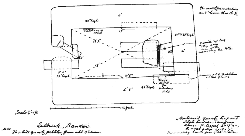
Fig 35 Sulbrick, Santan
The building- measures about 17 ft. by 8 ft. 6 ins., and the walls still stand from 2 to 4 ft. high. They vary- in width from 3 ft. at the west to 4 ft. 6 ins. on the south, and are built of boulders and surface stones, large and small, of quartz, trap and slate. Three or four of larger size were set on end. Curiously, the east wall had a facing only on the inside, whilst outside it was roughly built against the sustaining bank. No doubt above the level of this it would also have been faced externally. .
The south wall has settled inwards at its west end and in it, at a height from the floor of 4 ft., was a projecting stone 7 ins. long by 7 ins. wide by 2 ins. thick, which might possibly have served as a bracket on which to set a small lamp.
The doorway towards the north side of the west wall had been filled in, but was marked outside by a lower jamb stone of white quartz on the north, and inside by a flag which appeared to be the sill-stone, measuring 2 ft. 6 ins. by 12 and 2 ins. thick. The door-jambs had been built in courses.
We found no trace of the east window, the wall there being scarcely high enough, but we thought we could detect the bed of the sill of a small window in the south wall at a height of 3 ft. 6 ins. from the floor and at a distance from the east corner of 13 ins.
There were remains of floor pavement of small stones of irregular size and shape, mostly near the entrance. The base of the altar could be traced, measuring 4 ft. 3 ins. along the wall by 2 ft. in the north to 2 ft. 6 ins. wide on its south side.
The front length narrowed to 3 ft.7 ins. l t was froth 18 to 24 ins. high, built of rather large stones. Lying before this, and serving as a narrow step, or possibly as a support for a frontal slab, was a granite stone 3 ft. long by 4 ins. wide and 18 ins. deep. In front of this stone lay a large slab which from its shape seemed as if it might have been the covering stone of the altar. Just below the floor, near the west end of the north wall, were traces of ashes covering a space of about 12 ins. square,.
Inside and just outside of the Keeill, thirteen lintel graves were met with, five of which passed under the walls, suggesting that the present ruin must represent a rebuilding and possibly an enlargement of the original structure. Two other graves just in front of the altar probably belonged to the period of this later building. These graves (12ins. below the floor), were 6 ft. long by 14 ins. to 20 ins. wide and 12 ins. deep, lined by very rough brittle slabs and orientated with the building. One, however, which was only 4 ft. long by 12 ins. wide, ran from north-west to south east.
The grave under the south wall differed by having no lintels, the body having perhaps been wrapped in a woollen cloth and laid there in the earth. This was covered with white shiore pebbles, of whiclii nearly 80 were counted in the Keeill, but they were met with in only one of the graves besides this one.
Outside was the customary bank against the walls, formed of earth and large stones, and from 3 ft. to 6 ft. wide.
Little trace of the original enclosure now remains, but its outline could be recognised by the slightly raised surface. The early Cross-slab -'Manx Crosses' 35) (renumbered 62) - must have come from this graveyard. [See Fig. 38, Plate XXII.] At the time of the O.S., on which it is marked XIII, 13 (270), it stood by the side of a streamlet at the Ballacorris Mill, 3 furlongs south south-east of the Keeill, whence it was removed many years ago. It is now set up with the others in the Parish Church.
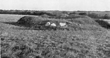
Fig 36. Santan. View of the Ruins of the Keeill at Sulbrick. Taken in 1935
A view of the ruins of the Keeill at Sulbrick was taken in 1935. [See Fig. 36, Plate XXIV.]
On Ballahowin, adjoining Sulbrick, about 250 yards north east of this Keeill, XIII, 9 (40), about half way between the crest of the Hill and Stuggadoo, is a 'Healing well.' It is told how, in recent times, it was discovered by a man who had killed his dog with a stone; he threw it into this well, and the dog thereupon recovered. [Note 22.]
BALLAVARTIN. In a field by the high road, nearly opposite 'the Gate,' is a low mound not marked on the Ordnance, on which it would be XIII, 13 (376), at a height of 405 ft. About 50 years ago an excavation made here in the course of some farm work brought to light the remains of walling, the stones of which were removed. This was thought to have been a Keeill and, if so, the name of the farm suggests that it may have been a dedication to St. Martin and, consequently of very early date. When our survey was being conducted in the district the field was under crop, so that we were unable to do any further digging at that time.
BALLAVALE,. O.S. XII, 1 (615). This site is marked on the Ordnance shect as 73 yards north of the house, but our excavations proved that that was an error. At that point, the rock crops out and -there has been some quarrying, but it is still remembered that when excavating- for the foundations of the present dwelling house lintel graves were met with, and there can be no doubt that the house itself in part occupies the site of the Keeill (at a height above sea-level of some 230 ft.). The name is lost, and there is no further memory of it. A stone basin from the Keeill, thought to have been a font, but more likely a knocking-stone for bruising barley, was presented by Mr. Martin to the Manx Museum. [Note 23.]
BALLACRAGGA. O.S. XVII, 2 (928). The site of this Keeill is as marked on the Ordnance Sheet, namely, about 73 yards south east of the house at a height above sea-level of 265 ft. Trenches were dug across the ground at intervals of about 6 yards, and, though no foundations were now met with, one or two lintel paves were found acid some white shore pebbles, whilst a layer of chips and splinters of stone appeared to mark the actual position of the Keeill, of which all other traces has long since been carried away. [ Note 24.]
The enclosure boundary could in part be traced, at the time of the Ordnance Survey this was more distinct, and it is there shown as
BALNAHOW. O.S. XVII, 2 (948). The remains of this Keeill have been removed even more recently than the last, a former tenant who carted them away telling us that he had not known it was a Keeill. It stood about 133 yards north of the farm buildings at the height of about 340 ft. The enclosure is marked on the Ordnance Sheet, measuring about 75 ft. east and west by 30 ft. north and south (making about 25 perches, or a little over half a rood), and having the Keeill at its south east end.
From this Keeill came the broken cross-slab (' Manx Crosses' 68, renumbered 95) first mentioned by Dr. Oswald. It is now placed with the others in the Parish Church. [See Fig. 39, Plate XXV.] [Note 25.]
BALLAFURT. O.S. XVII, 5 (1078). The site of this Keeill is still remembered, at a distance of 250 yards north of the house, and at a height above sea-level of 245 ft., but we were unable to learn any particulars of it. [Note 26.]
ROGAINE-BEG. The late Mr. Bacon some years ago came across some lintel graves in a field close to Cronk ny Marroo. This must be the site referred to by Oswald, who, speaking of the same Cronk ('Manx Society,' Vol. v, p. 51), goes on to say ' on the broogh behind it and inward the mud foundations of a small oblong and frail tenement . . are very distinctly traceable (i.e., in 1860), occupying nearly all the flat summit of the precipice.' It is not marked on the O.S., but would be XVII, 5 (1152). [Note 27.]
Note 22. - ' Sulbrick.' Ord. Surv. particulars: ' A short distance S. of Sulbrick are the remains of an ancient Chapel; the walls are in a good state and stand about 3 ft. above the ground. There is no tradition of a Burial Ground having existed in the vicinity.' Authority quoted: Dr. Oliver, Douglas.
Note 23. ' Ballavale.' Ord. Surv. particulars: 'On the lawn before the mansion is pointed out the site of an ancient Chapel and Burial Ground; numbers of stone-lined graves containing human bones have been found.' Authority quoted: Dr. Oliver, Douglas.
Note 24. - ' Ballacregga.' Ord. Surv. particulars : ' To the immediate E. of Ballacregga is the site of an ancient Chapel and Burial Ground, where numbers of stone-lined graves containing human bones have been found. The enclosure is all that is now traceable.' Authorities quoted: Mr. T. Quinney; Mr. R. Cowin, Ballacregga; Mr. W. Moore, Ballavilley; Dr. Oliver, Douglas , Oswald's Vestigia.
Note 25. - ' Ballnahow.' Ord. Surv. particulars : ' In a field to the immediate N. of Balnahow are pointed out the remains of an ancient Chapel and Burial Ground; the remains are very distinct, being (with the exception of a small portion of the enclosure) from two to three feet above ground. Numbers of stone-lined graves containing human bones have been turned up by the present tenant, Mr. T. Quinney.' ' The old chapel on the estate of Balnahow, Santan.' Oswald's Vestigia. Authorities quoted are: Mr. T. Quinney; Mr. R. Cowin, Balla- cregga; Mr. W. Moore, Ballavilley; Dr. Oliver,Douglas.
Note 26. - ' Ballafurt.' Ord. Surv. particulars : ' A short distance N.W. of Ballafurt is pointed out the site of an Ancient Chapel and Burial Ground; numbers of stone-lined graves containing human bones have been turned up by the plough. Authorities quoted: Mr. John Cain; Mr. John Moore; Mr. T. Quinney, Ballacrine; Dr. Oliver, Douglas.
Note 27. - ' Cronk ny Marroo.' Ord. Surv. particulars : ' A remarkable tumulus situated on the N.E. headland of Port Grenaugh; it is of oblong shape and on. the S.W. side are traceable the foundations of a small oblong building. Major Bacon, on whose land it stands, had the tumulus opened two years ago, but nothing was found. Tradition asserts it to be an ancient burial place. Signifies 'Hill of the Dead.' Various modes of spelling the same names. " Cronk-ny-Marroo ' (Major Bacon, Seafield) ; ' Cronk-ny-Marroo ' (Rev. G. Harvey) ; 'Cronk-ny-Marroo' (Kneale's Guide); 'Cronk-na-Myrriow' (Oswald's Vestigia) ; 'Cronk-ny-Marroo' (The Hill of the Dead (Many) );'Cronk y Merritt' (Hill of the Dead) (Dr. Oliver).
' On the sea cliff, across the isthmus of a small insulated crag overhanging the beach, is a sepulchral mound 40 ft. long, 12 ft. high and 20 ft. broad called Cronk-ny-Marroo or ' The Hill of the Dead,' where the slain are supposed to have been buried after some sanguinary engage- ment.' Kerruish's Guide, p. 147.
'The Cronk-na-Myrriow is a good specimen of the barrow of the sepulchral kind as we may presume from its name. It stands on the top of the sea cliffs, on the left of the creek of Grainich, in the Parish of Santan. It is an oblong and regularly formed turfy mound, 40 ft. long, 20 ft. broad and 12 ft. high, placed across the isthmus of a small insulated crag, which overhangs the gravelly beach of the little estuary of Grainich, and occupies the approach to the edge of the cliff so completely as to leave only a narrow and precarious footpath on the S.E. aspect. On the broogh behind it and inward, the mud foundations of a small oblong and frail tenement covered with a luxuriant verdure are very distinctly traceable, occupying nearly all the flat summit of the precipice, and combining with its simple solitude a degree of security rarely aimed at in such structures, this could only have been used as a religious retreat of no very ostentatious kind, perhaps the cell of a hermit.' Oswald's Vestigia.
|
|
||
| |
||
|
|
||
|
Any comments, errors or omissions gratefully received
The Editor HTML Transcription © F.Coakley , 2011 |
||