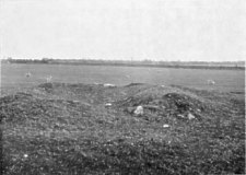
Fig. 2 Conchan Ruins of the Keeill, Upper Sulby
from a photo taken in 1935
[From 5th Report - 1918]
TO THE ISLE OF MAN NATURAL HISTORY AND ANTIQUARIAN SOCIETY.
Fifth Report of the Manx Archaeological Survey.
Foundations still remain of two Keeills in this parish; the sites of two others have been identified; and the possible site of a fifth is suggested by references in the 17th and 18th centuries to an Old Chapel (near the river mouth, Douglas), which may have been on the site of an early Keeill. (See notes.)
(1) Ruins of Keeill on the Quarterland of Upper Sulby, Abbey Lands. [4° 29' 5" W.; 54 11' 24" N.]
(2) Foundations of Keeill Vartin on the Quarterland of Ballakilmartin, Treen of Begoade. [4° 26' 33" W.; 54 11' 5" N.]
(3) Site of Keeill on the Quarterland of Glencrutchery, Treen of Tromode. [4° 28' 22" W.; 54 10' 13" N.]
(4) Site of Keeill on the Quarterland of Ballaquayle, Treen of Douglas. [4° 29' 3" W.; 54 9' 45" N.]
(5) Possible site of Keeill (near Old St. Matthew's), Douglas, Freehold. [See Note 8.]
Conchan Parish Church, O.S. XIV, 1 (2061) [4' 27' 2" W.; 54 10' 21" N.] the site of which is freehold, probably occupies that of an early Keeill, as suggested by the cross slabs found there including Scandinavian and Anglican pieces, together with Celtic slabs which are as early as 7th century. [Note 1.] A Cross, which may be of the 12th century [Fig. 15, Plate XII.], set up in S. Catherine's garden, has not hitherto been figured or described. The name of this village, which about half a century ago, was Kiondroghad, and the Droghad must have been the bridge or causeway - now represented by that part of the road opposite the old school, which led across the boggy depression to the Keeill. The little meadow (2057) here bore the curious name of Casa. [Note 2.]
UPPER SULBY. O.S. X, 16 (1018). [See Fig. 1, Plate I.] The ruins of this Keeill stand about 440 feet above sea-level, in a field on the west side of the farm lane and about 210 yards S.W. of the house. A turf 'mound marked the outline of the building- raising expectations which were dis- appointed when our digging revealed how little was left of the walling, scarcely- more than two courses being in position anywhere inside, while, of the north wall, even the foundations had been carried away. Outside was rather better, the south wall reaching a height of four feet.
With some difficulty we were able to fix the four internal corners, by which the measurements were shown to be about 21 ft. by 8 ft. The eastern end of the north wall remained in parts from 2 ft. to 2 ft. 6 ins. high; the east wall, 3 ft. to 3 ft. 6 ins.; the south about 18 ins. (inside), and the west at its northern end up to 2 ft. They varied in width from 4 ft. to 4 ft. 6 ins. can the south, and were built Avith an inner and an outer facing- of stones with a core of earth and rubble.
Some of the foundation stones still remaining inside were of good size. On the south was one 44 inches (of which 8 in. projected into the east gable) by 6 to 7 ins. wide, and 10 ins. high; another, 38 ins. by 2½ to 5 ins. and 10 ins. high. Between these two a smaller one had fallen forwards which was of the same height, so that we may regard 10 ins. as the level of the skirting on the south.
At the east end of the north wall there remained one slab on edge, 23 by 24 ins. and 4 to 5 ins. thick, so that it had probably had a similar skirting. Another large foundation stone on edge was on the north side of the vest wall over 42 ins. long by 5 to 6 ins. wide and about 8 ins. high.
The doorway was nearer the south than the north end of the west wall, and appeared to have been only 18 ins. wide inside to 20 ins. at the outside. The south jamb was represented by an outer corner stone, laid flat, 16 ins. by 8 ins. by 6 ins., and by two flagstones on edge, 24 ins. by 9 ins. and 3 iris. thick and 20 ins. by 9 ins. by 2 ins.; these had slipped forward.
The north jamb was built in courses of small stones with a rather target- one flat at its inner and another at its outer corner; 15 by 13 by 3 to 4 ins, and 18 by 15 by 3 ins. A small flagstone remained across the entrance outside, and there had been a step down into the interior.
The east wall, which had settled inwards, showed its lower course to consist of rather smaller stones, being about 12 ins. square. Tie altar had its lowest course remaining in position slightly nearer to the south than the north end of the gable: it measured 32 ins. long , by only 18 ins. wide and might originally have been a few inches larger by having a facing of flags. The two corner stones on the inner side of the altar against the wall were set on end, but of small size being only 12 ins. above the floor level.
Outside were traces of the customary bank against the walls 4 ft. wide and on the south 6 ft. wide. The hedge of the field which is here recessed and forms a boundary with the adjoining farm of Lower Sulby, is almost certainly on the ancient line of the enclosure or cemetery on its north and west sides. From the eastern corner of this northern fence, a line of about 37 yards would reach a low ridge which looks like that of the south fence of the enclosure extending to a point about 26 yards from its west boundary. Some large stones may even mark the position of the original entrance. The area enclosed does not appear to be definitely marked, the Keeill being set rather nearer to its south east end.
Opposite to the middle of the south wall of the Keeill, at a point only two feet from its outer face, and so under its supporting bank, we found a lintel grave, Avith remains, crushed in, of another just outside of it. These were formed of thin flags on edge at the sides and ends, not paved below, and covered by smaller flags across. Nothing but some black unctuous matter now remained in them. About three dozen white shore pebbles of ordinary size, that is to saw about 2 ins. by 1½ ins., were met with in the soil above the graves, and 75 were counted measuring not more than ½in. by ¾ in. One or two pebbles also were found near the altar.
The aspect of the Keeill is south west, its orientation by compass about east south east. [Note 3.]
Fig. 2 Conchan Ruins of the Keeill, Upper Sulby
from a photo taken in 1935
A photograph was taken of the site in 1935. [See Fig. 2, Plate II.]
KIEEL MERTIN. On Ballakilmartin. O.S. XI, 13 (1480). [See Fig. 3, Plate III] About 350 feet above sea-level at the entrance to a field, 168 yards north north-east of the house and about 300 yards north-Avest of the highroad from Douglas to Ramsey.
The farm road had cut through the burial ground and the sod fence between it and the field crossed the Keeill diagonally, cutting- off about half of it. The Keeill appears to have measured about 18 ft. by 9 ft. The foundations of the east wall remain 3 ft. 3 ins. wide, but picked away towards the north end; it is built of stone throughout and shows a plinth or footing outside 8 ins. wide.
The south wall, now two feet high inside and 4 ft. wide, has a similar footing. It is formed by a facing of stone inside and outside about 9 ins. thick and filled in with heavy, red, sandy loam. This wall had a skirting of stones on end of which four remained at the east end - 14 ins. long by 24 ins. high, and from 4 to 9 ins. thick, 8 ins. by 20 ins., 22 by 20 ins., and 12 by 14 ins. [See Fig. 4, Plate II.]
At the west end were two 19 ins. by 15 ins. and 3 to 4 ins. thick, and 27 by 14 by 3 ins. A small boulder 5 ins. by 13 ins. high appeared to mark the inner corner. These upright stones were set to a depth of about 6 ins. below the floor level, as shown by some pavement stones still in position.
Upon digging into the hedge we found apparent traces of the north-east corner, and at the other end what looked like foundations, 4 ft. wide, of the west wall, a gap in which near its southern end might represent the position of the doorway.
Along the south wall the outside bank remains, but dies away at the east end. It extends to a width at the base of from 8 to 12 ft., and at the south-west, in wliiicli direction the ground falls, is 5 ft. high.
The base of the altar at 2 ft. from the south corner shows it to have been about 5 ft. by 2 ft. wide. Some of the floor pavement was in position, the irregularly shaped stones averaging about 9 ins. by 6 ins. and 12 ins. thick. We met with a score of white shore pebbles, chiefly towards the east end at the floor level. Nine of them were found to average 14 ins. by 1 in. by 2 in. One was fully twice as large, some were smaller.
In seeking for traces of the west wall we came across some crushed and decomposed pottery with a little wood charcoal. A careful examination revealed no trace of bone; probably it had got washed away, but there could be no doubt that this was a Cinerary Urn, probably about 12 ins. diam. Its shape could not now be determined, and if it had had any ornament this was now scaled off.
The aspect of the Keeill was south-west; its orientation, so far as could be judged from the south wall, east north-east by compass. The enclosure or cemetery is marked on the O.S. as .059 acres; it must, however, have been about four times as large; lintel graves have been met with in the field across the road. [Note 4.]
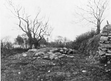
Fig 5 Ruins of the Keeil, Ballakilmertin
A photograph of the ruins of the Keeill was taken in 1935. [See Fig. 5, Plate IV.]
GLENCRUTCHERY. O.S. XII, 4 (1806). The O.S. marks this as the site of a ' Chapel and Burial Ground ' 360 yards south south-west of the house, at a height above sea-level of about 290 ft. Some large quartz boulders have given it the name of the 'White Lady.' [See Fig. 6, Plate IV.] Graves have been found and traces of cremation, showing that, as in other instances, the Keeill was set on the site of a Bronze-age burial. [Note 5.]
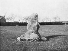
Fig 6. The 'White Lady', Glencrutchery
BALLAQUAYLE. This site is not marked on the O.S., but would be XIII, 8 (2168), where, in November, 1915, graves were discovered in the course of clearing the ground for the new Secondary School at Douglas. [See Fig. 7, Plate V.] Upon removing a portion of the sod fence on the south-east side of Brae-Hill road, several lintel graves were found 333 yards south-west of S. Ninian's Church, and at a height above the sea-level of about 140 ft. The sides of the graves were composed of four to five thin flagstones on edge, the ends closed by larger slabs, the floors unpaved, the tops covered by small flags. One grave measured 5 ft. 4 ins. by 18 to 24 ins. wide and about 14 ins. deep; three others were of about the same length but rather narrower, while one was only 3 ft. 6 ins. long. Nothing was found to indicate their period, but the facts that the bones had almost perished and that the stones themselves were so decayed that they fell to pieces after exposure and handling, point to an early date. Their orientation was almost due north-east and they were undoubtedly remains of a Christian cemetery which had been cut through by the road, the graves being preserved by the sod fence which was built over them. Probably others lie concealed beneath the hedge on the other side of the road as well as in the field on the north-west of it, where it is possible that the foundations of a Keeill may still lie buried.
THE DOUGLAS CHAPEL. There was a Chapel near the harbour, Douglas, at about the position of the present Cattle Mart and near Old St. Matthew's. This is not marked on the O.S., but would be XIII, 12 (2594). By deed dated 19th October, 1708, Bishop Wilson, John Murrey and others, 'undertakers for the building of the new Chapel (S. Matthew's) in Douglas,' sold 'the ruins and ground whereon the Old Chapel [Note 6.] did stand' with ' wast ground and easements properly belonging to the same' subject to the annual rent of sixpence ' being the rent of the house or ground whereon the New Chappell is now erected,' etc. At a Sheading Court previously held, liberty was granted for such sale of this waste ground and that it should be subject to the Lord's rent 'which was formerly payable out of the ground whereon the New Chappell stands.'
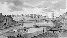
Fig 8. The earliest picture of Douglas Town
The chapel is indicated by a cross on the tower
The drawing is attributed to James Chaloner c. 1652. He became Governor
in 1659
A plan of Douglas by J. Taggart, 1834, marks 'S. Martin's Lane ' running from the Market Place to the quay which might have been on the way to the 'Old Chappell.' We are told by Mr. William Cubbon that about 20 years ago lintel graves were found close to the present Cattle Market, and this would seem to have been the site of the Chapel. A print in the British Museum, about 1652, shows a Chapel with a cross on the tower; [See Fig. 8, Plate VI.]; and as the Church is marked on Durham's map, 1595, published by Speed in 1605, it must have been standing in the 16th century. The Rev. S. N. Harrison tells us that in 1633 this was referred to in the Archdeacon's register as ' Capella de Douglas,' and a MS. of Vicar-General Cubbon has a note of that date of a Court having been held in ' Cappella Dominica de Douglas 'which must have been the same. This is very interesting; the word is probably not the name of a Saint, but stands for ' Dominica,' an adjective meaning the ' Lord's.' This was the term introduced by the first missionaries for ' Church'; in Ireland it became Donagh, as in Donagh Patrick, and in the Isle of Man, Doonee, as in Knock y Doonee, Kirk Andreas, and in Cronk y Doonee, Kirk Christ Rushen. [Note 7.]
The change of Lord's rent is noteworthy, but for the purpose of our present argument it is more interesting to learn that the site of the Old Chapel was Freehold as this strengthens the view that it was ancient Church land; and the old name of the lane which may quite likely have been derived from that of the Chapel, points to a dedication to S. Martin and thus to the original foundation having been that of a Keeill of our earliest period. [Note 8.]
Note 1. - From Ord. Sur. Name Books, 1866-72: ' a handsome edifice, being the Parish Church. It was rebuilt in 1833 and contains accommodation for about 500 hearers. In the churchyard are two ancient Runic Crosses - that nearest the E. wall is in a good state of preservation, the other much broken.' Authorities quoted are: Rev. John Howard, Mr. S. Callow, Mr. Cowley.
Note 2. - Six lines from foot page, ' Casa' : This is, in all likelihood, the Irish ' Cashey,' meaning, according to Mr. J. J. Kneen ('Place-Names, p. 143), a kind of causeway made of wickerwork, and sometimes of boughs of trees and brambles across a small river, a marsh or a deep bog. The little meadow probably got its name from the 'Cashey' which stood over the path to the chapel.
Note 3. - Ord. Surv, particulars : ' Situated in a field to the E. are the remains of an Ancient Chapel and enclosure in a good state of preservation, the walls, which are formed of stones and mud, being about two or three feet above ground.'
Note 4. - Ballakilmertin. Ord. Surv. particulars: ' A short distance N. of the buildings is pointed out the site of the Ancient Chapel and Burial Ground of St. Martin's. Mr. Christian, the proprietor, has several times, wbilst ploughing, turned up ' Kistvaens ' containing human remains.' Authorities quoted are: Mr. Christian; Mr. Cain, Ballig; Mr. Christian Begoade; Dr. Oliver, Douglas.
Note 5. - Glencrutchery. Ord. Surv. particulars : 'Well-known in the district as the site of an Ancient Chapel and Burial Ground. The authorities mentioned have frequently seen stone coffins raised, containing a soft matter. The site is marked by a stone, and no vestige of the boundary is visible.' Authorities quoted are: Mr. W. H. Cubbin, Summerhill ; Mr. R. Killip. Onchan ; Mr. T. Quine, Burnt Mill Hill.
Note 6. - 'Present Cattle Mart.' The site of the Cattle Mart is now occupied by the Corporation Electricity Works.
Note 7. - ' Doonagh.' The Irish Domhnach is the nominative. In Man the nominative would be Doonagh and the genitive Doonee as in Knoc y Doonee.
Note 8. - The question as to what chapels had existed in Douglas prior to St. Matthew's in 1708 frequently occupied the mind of Mr. Kermode, and we often discussed it. He has given above details of a chapel which may well have been dedicated to St. Martin of Tours. The building in the foreground with a cross on the steeple appears to be on the site of what later became the Cattle Market, and is now the site of part of the electricity works of the Corporation. [See Plate VI.]
To judge from John Wood's plan of 1833 and J. Taggart's plan of 1834, both very reliable, 'The Chappell ' shown on the Chaloner sketch of c. 1652 - presumably St. Martin's - must have been on or near the building marked with the figure 5 on Wood's plan and with a T on Taggart's. They both were in Heywood Place, and stand out on the quayside very near to the east entrance to Queen Street.
We have also ample evidence of the existence, at the same time, of another chapel, the one dedicated to St. Mary. Its site was, in all likelihood, near to that of Old St. Matthew's at the market-place. Mr. J. J. Kneen ('Place Names,' p. 225), in referring to St. Mary's Chapel, states : 'It is almost certain that this chapel must have been surrounded by a churchyard which may have been represented by the old market and the ' Fairy Ground,' ' Fairy ' being a corruption of 'Fair.'
Mention of Early Churches in Douglas are not frequent. The reference in the Chronicon Manniae to Robert Bruce having spent a night in May, 1313 - ' ad Moniales de Duglas ' - might reasonably have been to the Monastery of St. Mary in that town.
There is a further reference to the Monastery of Douglas in one of the Castle Rushen Papers in the Manx Museum. It is in a brief note in Latin written in 1511. Mr. P. G. Ralfe translates the note as follows: ' Antony, Bishop of Durham, Patriarch and Lord of Man, gave 'the Church of St. Conchan to the Monastery o f the Blessed Mary of Douglas in full jurisdiction. At Wooton, as I think, in the year of the Lord 1408, Richard, by the grace of God ' Bishop of Sodor had a great inquiry concerning the Monastery of Douglas and by the inquiry ' adjudged to the said Monastery of the Cistercian Order . . . . under the seal . . . . in ' witness, Anno Domini, 1414 aforesaid, and that it was founded by Reginald, King of Man. 'who died in the year of the Lord 1226. This from the deed aforesaid.'
It is worthy of note that Antony de Beck. was Lord of Man from 1298 to 1310. The Bishop of Sodor at the time was John Sproton. The Richard in the MS. must have been Richard Payl, who was translated from the See of Dromore by Pope John XXIII on May 30th, 1410. He was still Bishop in 1421, when he blessed the new Abbot of Iona.
In the Liber Causarum, 1685, according to notes made by Vicar-General Thomas Cubbon, 'there was a Convocation held in St. Mary's o f Douglas, when several constitucons were made by Baptista Sodorensis' (Bishop Baptista Levinz).
In the 1703 Manorial Roll, which was written before St. Matthew's Chapel was erected in 1708, there are mentioned (a) 'the Chappell ' and (b) 'the Old Chappell.' This shows that there were two chapels in existence contemporaneously prior to St. Matthew's. One of these (as Mr. Kermode points out) is shown in an old sketch, thought to have been made by Governor Chaloner about 1652, and found with others in the British Museum. This sketch is reproduced on Plate VI. This was probably that dedicated to St. Martin.
Here follow further references in the Manorial Roll of 1703. Under the heading 'Cotages in Douglas'; ' The Executors of Ito : Murrey late of Ramsey for a long cellar at the Cross, rent vid. . . . Mr. John Murrey, merch. for a stable at the Chappell, rent vid. a garden above the Chappell bought from widow Cotyle, rent xiid. . . . .the vid. is a house near the Old Chappell sold to Rich'. Ffitsimons.. . . .' Dan Christian Bemaughagg, for a Sellar above
The Cross, rent iid.' . . . 'Rich. Joyner for a garden at the Chappell xiid. Itm. for a house at the Chappell hill vid. ' Cap. John Oates for a dwelling house brewhouse out Sellr and backside near the Cross, rent xiid. comp'. for in 1643 by S" Jo. Oates.. . . . ' Mrs Marg'. Christian for the Nunnery Sellar, rent viid.' . . . ' Issa the widow of Anthony Nicolson of Whitehaven for a Little Sellar at the Cross, rent iiiid.'
In a copy of Liber Scacc. (1764; 6093), under date 1640, there is a record of ' a contribution for building a chapel at Douglas,' when the 'farmers' contribution ' to the building was 'not to be made a president' . . . 'the cotlers to be assessed to ease the poor farmers.' (p. 130 in original Liber.)
In a copy of another Liber Scacc. (1764; 5990), under date 1641, there is the brief record : 'Eighty pounds collected towards the building Douglas Chappel.' (p. 35 in original Liber.)
It may be interesting to add here that what is now Drumgold Street was, according to the Isle of Man Gazette of 1812, named Red Cross Street. There is recorded in the same year in this paper's columns an advertisement of ' an auction of a schooner at the Cross.'
|
|
||
| |
||
|
|
||
|
Any comments, errors or omissions gratefully received
The Editor HTML Transcription © F.Coakley , 2011 |
||