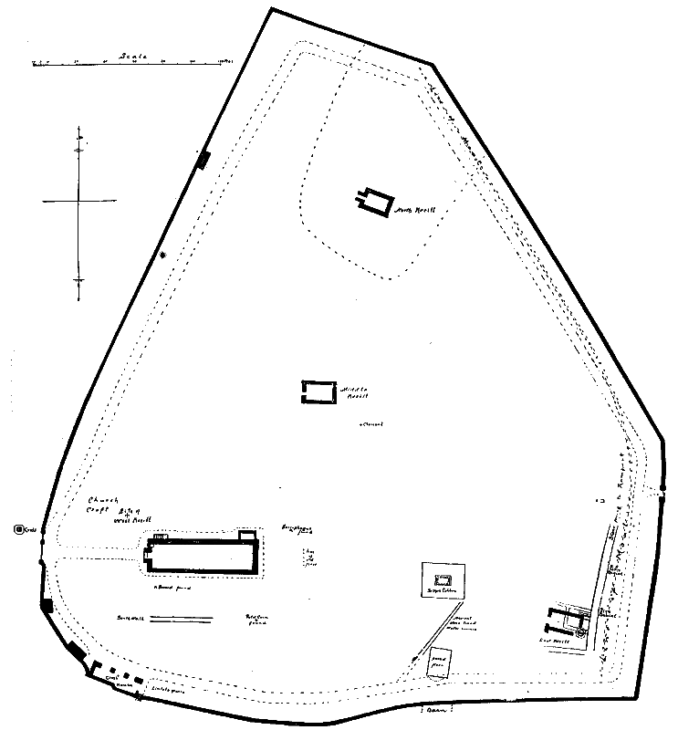
Fig. 7. Plan of Maughold Church-yard.
[From 4th Report - 1915]
We have been able to trace the remains or the sites of the following Keeills in this parish
1. S. Mary's, on the Quarterland of Ballastole, Treen of Ballure.
2. Burial Ground and possible Site of Keeill, on the Quarterland of Folieu and
Treen of Lewaigue.
3. Site of Keeill on Ballaterson West, Treen of Ballaterson.
4. Parish Churchyard. Ruins of Northern Keeill and Burial Ground at the North
end of churchyard.
5. Parish Churchyard. Foundations of Middle Keeill, about 35 yds. N. of the
East gable of Church.
6. Parish Churchyard. Site of Western Keeill, a little W.N.W. of Church porch.
7. Parish Churchyard. Foundations of Eastern Keeill, about 69 yds. E.S.E. of
the Church.
8. Site of Keeill on Ballagilley, Treen of Ballagilley.
9. Site of Keeill Malony, on Ballajora. Particles.
10. Site of Keeill on Ballaglass, Treen of Cardall.
11. Ruins of Keeill on Cardle Veg, Treen of Cardall.
12. Site of Keeill, Cronk y Noe. Intacks, Magher breck.
13. Site of Keeill Croit ny Howe on Ballafayle y Kerruish, Barony of S. Bees.
14. Keeill Chiggyrt, on Ballafayle y Cannell, Treen of Ballafayle.
15. Keeill Woirrey. Corna Intacks.
16. Site of Keeill on Ballachrink, Treen of Corna.
17. Site of Keeill on Ballashellaig, Cuarterland of Ballacorteen, Treen of Corna.
18. Site of Keeill. Intack on the Eastern slope,of Slieau Ruy.
19. Foundations of Keeill Vail, Barony.
O.S., V, 16 (771), has been frequently restored and more than once enlarged. The foundations may be of the eleventh century as at least one fragment of carved stone certainly belongs to that period. Parts of the walls are of twelfth century as shown by the two side lights in the Fast gable, while remains of several more 12th century windows have been met with. Within the walls also have been found some thirteenth and fourteenth century remains, and some possibly of fifteenth century. The whole place is of such exceptional interest that we feel we should go beyond the scope of our original design, which was to record remains earlier than the twelfth century, and give a brief description of the chief of the architectural details found here.
The Churchyard as a whole, -See Plan, Fig. 7,-though not precisely as now bounded, is undoubtedly ancient and long held in veneration as a place of peculiar sanctity. In our Manx Chronicle mention is made of the pastoral staff which, in 1158, was brought by the priests and clerks to prevent the raid of Gilcolman under Somerled. Though now lost, its memory is preserved in the name 'Staffland,' of which the chief estate, consisting of 68 acres, adjoins the churchyard, so called, undoubtedly, from the fact that these lands were, under the Celtic system, assigned to the hereditary keepers of the staff, or "bachal." The churchyard now covers an area of about four acres. The whole length of its eastern boundary was protected by a strong rampart which was shown by our excavations to have been formed by a dry stone wall six feet wide ; over this Mr. Harrison remembered there had been an earthen embankment which sloped outwards to a moat. We traced this walling to its S. E. end where it was met by the southern boundary, consisting of a wall three feet wide and well built of large stones. The Cross-house erected in the churchyard contains with the nine pieces brought in from various keeills in the parish, the exceptional number of forty-two sepulchral monuments dating from the sixth to the thirteenth century, and belonging to our Celtic, Anglian and Scandinavian periods. Of these, at least three which are earlier than the eleventh century were erected to bishops or abbots, and altogether it looks as though we had at Maughold an establishment with the characteristics of the earliest Irish monasteries, that is to say, an enclosure surrounded by a cashel or defensive work, containing several churches, with abbot's house, guest house, refectory, and separate cells for the monks, together with barns and outhouses. It is not to be wondered at that in the passing of the centuries all further trace of them is lost to us when we reflect that even in Columba's establishment in Iona, the original structures were of wattles and sods, and that had it not been for his biographer Adamnan who was one of his successors, we should not have been able even to identify the site. Unfortunately there was no one to record either the origin of the foundations or the nature and extent of the earliest buildings at Kirk Maughold.
Fig. 7. Plan of Maughold Church-yard.
The Rev. Canon Quine has recently made the very interesting discovery that in certain of the S. Bees' Charters relating to Church lands in this Parish, there is record for the first time in the Isle of Man of a dedication to S. Olaf ; and from the context it seems probable that this S. Olaf's was the actual building of our present parish church.
We figure some of the remains known or at different times recovered in the building of the Church or its surroundings.
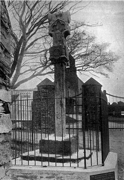
Fig. 8. View of standing Cross, Maughold.
The first to strike the eye is the standing Cross outside the gate, which is on the West, facing the road from Ramsey ; it is the only monument of its kind in the Isle of Man, and has not previously been fully or correctly described or adequately figured. In the absence of record, or even tradition, it is only possible to date it from its architectural design and workmanship in which however there are peculiarities making this very difficult. It is of S. Bees' sandstone : it has been suggested that the shaft may be older than the present head, yet one would expect that such a finely carved head would only have been set on a shaft expressly designed for it. The Cross was formed of five stones, namely,-base, shaft, neck, head and a covering stone which is lost.
We found that the base rested on a square plinth consisting of a fine slab of a local trap rock, 36 to 48 ins. by about 40 to 54 ins., and 3 to 4 ins. thick. From the base, which measures 24 toa6ins. square by 14ins.high, into which it is fitted by a strong tenon,rises a slender octagonal shaft, 5ft. 1 in. high and 9 ins. wide; from points about 2 ins. from the top and Sins. from the bottom, the shaft is square, and, between these points, octagonal. The neck is formed of a square stone 14 ins. high by 14 ins. wide, pierced through to receive the tenons of the shaft and of the head ; at about the middle of its height it is crossed by a narrow bead moulding from which its corners are splayed outwards for half an inch, and beneath this is a wide hollow moulding terminating in a heavier bead. The head is fitted into the neck with a large tenon and measures 31 ins. high by 10 to 18 ins. wide, and 8 ins. deep ; from a point at 12 ins. high it is recessed at the sides so as to leave the upper part of the front and back practically square. The present top is flat and dowel-holes in it prove that it was originally crowned by another stone.
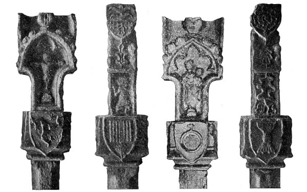
Fig. 9. Standing Cross, Maughold, Enlarged views of the four faces.
By way of ornament the neck bears a shield on each of its four sides, about ra ins. high by 9 ins. wide, with devices carved in relief. That facing East displays the Three Legs armed with large spurs, but set in a direction contrary to that of recent times, being the same as on our twelfth century Sword of State. This seems to be certainly intended for a heraldic device, referring to the lordship of the Island. The southern shield contains a square figure with vertical grooves, below which is set a conventional leaf, possibly intended for the Palm with a symbolic reference to the Blessed Virgin. The western shield displays a circular ring surmounted by a plain crosslet and enclosing a cinquefoil device of heart-shaped leaves. The North shield has a Chalice, the base of which exhibits the pointed claws of the period.
The head stands in from the neck 2 ins. at the sides and 3 ins. at front and back ; each face shows a deeply-recessed canopy, arched and crocketed, the eastern one having in very bold relief, within a trefoil arch, a figure of Christ on the Cross set on a 'Calvary'; the western one has the Virgin and Child standing on a step within an arch which is cinquefoil; each face shows, above the arch, the lower portion of a foliated terminal which would have been continued in the missing stone above. On the south side, in the recess below the head of the arch, is the kneeling figure of a Knight with hands uplifted in prayer, above which is an oakleaf surmounted by a shield measuring 10 by 8 in. with a fanciful device as of two Chiefs wavy, with three oak-leaves below; this appears not to be heraldic. The northern side shows three oak-leaves in the recess, another oak-leaf between the crockets, and a shield displaying the figure of a Rose. This latter figure has caused the monument to be regarded as late, but, the rose is met with as an heraldic charge as early as 1250-1300, and the general appearance of the Cross seems to be in keeping with fourteenth century work; the shaft, as already stated, has been thought to be of a yet earlier date.
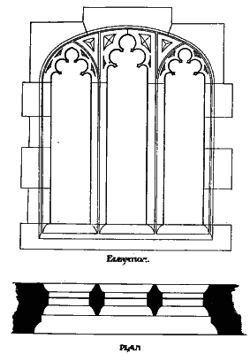
Fig. 10. East Window, Maughold.
A former East window. now built into the gable below the present one, is of the same material and probably of the same age as the standing Cross. Fig. 10, from a drawing to scale by Mr. L. Corkill, shows it to have been a three-light window with cinquefoil lights ; the arches of the side-lights are equilateral, the middle one, which is not distinguished by an arch, being separated from them by vertical mullions; and the arch over all is rather flat.
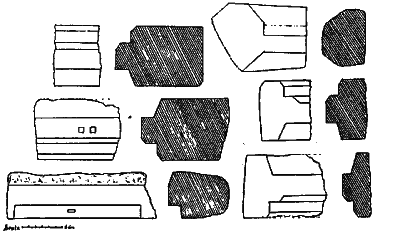
Fig. 11 Doorsills
Fragments of five doorsills similar in character, with plain chamfers, may belong to the same period.
A fragment of red sandstone, 15 ins. by 10 ins. and 6 ins. thick, shows in one piece portions of a sill with steep slope, and of base of a jamb.
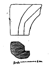
Fig. 12. Arch of Gréý Sandstone.
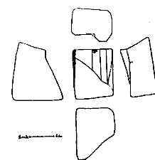
Fig. 13. Spring of Arch of Red Sandstone.
Fig, 14. Four-leaved flower ornament.
The following are difficult to date,-a piece of red sandstone, 11½ ins. by 7, and 5½ ins. high, badly broken, is formed from a rounded boulder, and shows a sharp corner recessed. The fragment of an arch of grey sandstone, 7½ to 13 ins. wide by 12 ins. high and 62 ins. thick, may be from a doorway.
The spring of a rather large arch is shown in a block of red sandstone, 12½ to 14½ ins high by 10 ins. long and from 7 to 13 ins. wide.
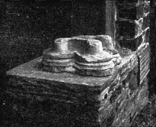
Fig. 15.Limestone Capital, View as seen upside down.
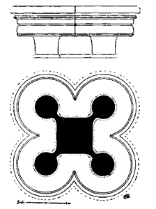
Fig. 16. Plan and Elevation.
The broken capital of a pillar of a pinkv-white limestone, foreign to the Island, appears to be work of the thirteenth century. It measures 18 ins. square, with a height of 8 ins., and shows
A loose block of yellow sandstone has its chamfered edge decorated with square fourleaved flower ornament. It measures gins. by 8Y ins., and 5% ins. thick. Each leaf is bordered by finely incised lines, with one on either side of the rib or angle at the middle.
The squares are 3 1/8 ins. diameter and set close together, the centre of each projecting in a blunt point. This might be from the side of a doorway and may be of the thirteenth century. It measures 18ins square, with a height of 8 ins, and shows below the moulding which is 3k ins. high, the tops of a central square, about 5Y 4 ins. diam., with four slender, rounded columns set at its corners. The edges both of the central square and of the columns are badly chipped but show traces of a surrounding fillet, ¼ in. deep, projecting about 1/8 in.*
*While the Church was being repaired, Mr. Harrison saw, built flat into the South Wall, a stone of the same material and having similar mouldings, which he described as the fragment of a triple arch of a blank arcade.
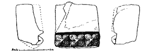
The shallow vaulting of the West porch has toothed ornament. As now seen, the arch is very flat and measures 4 ft. across, with a height at centre from the spring of the arch of only 15 ins. It consists of five stones about 12 ins. deep and 4r2 ins. thick, The edge is square in section and the tooth-figures are touching one another in squares of 2~/4 ins. diam., plain, with blunt points. The carving seems to be work of the twelfth century. The original would have been segmental in form and very possibly constituted one of three or four orders.
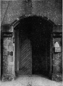
Fig. 17. West Porch, Kirk Maughold.
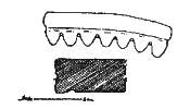
Fig. 18. Tooth ornament of Porch Front View and section of one stone.
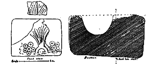
Fig. 19. Holy Water Stoup.Front view and section, with fragment of similar carving.
A holy-water stoup of a white sandstone measures 15½ ins. long by 9 to 10 ins. wide and 8 to gins. high. The round, cup-shaped hollow is 6 ins. diam., by about 4 ins. deep. The flat front of this has been nicely carved in low relief, about ½ in. for the figure and 1/8 in. for the raised lines on it, with a rayed design rising from a semicircle, and having on the left a cinquefoil, balanced doubtless by a similar one on the right, now flaked off. A fragment of the same material, 4 ins. by 1¾ ins. high and about 3 ins. deep, seems to have had a rayed design of like character.
Four or five fragments of pilasters of yellow sandstone, formerly set as jambs to the West door, each about 8 ins. high, show a plain rounded corner-moulding, with a narrower moulding at each side of it.
Fig. 20. Section of pilaster.
Fig. 2r. Corner mouldings.
Fig. 22. Capital yellow sandstone.
A broken block of red sandstone with plain, rounded moulding at the corner, may be from the jamb of a doorway. It measures 10 ins. by 11½ and 10 ins. high.
The broken capital of yellow sandstone, now 6½ ins. square by 4 ins. high, having a plain chamfer 22 ins. wide, appears to be twelfth century.
One of the two twelfth century, red sand-stone windows, revealed in the south wall in the course of repairs, is here figured. The light is É23 ins. high by 7 ins. wide, with an equilateral arch. The thickness of the wall is about 3 ft., and the jambs inside are seen to be angled to the splay- of 30 ins., and quite plain.
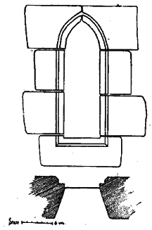
Fig. 23. Twelfth Century window.
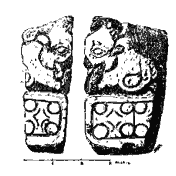
Fig. 24. Capital of purple grit, Irish romanesque.
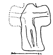
Fig. 25.Gable cross.
A most interesting discovery made at the time of these extensive repairs was that found loose in the walls, of a hard, dark, purple-red sand-stone or grit now 4½ ins. high by 2½ ins. wide and 1 3/4 ins. thick, showing in slight relief, a human head at the corner, with flourishes and, separated by a deep groove, a band of good diaper work. This evidently was the capital of a small pilaster, and its romanesque character dates it as of the I ith century. A gable-cross of yellow sand-stone, broken at 13½ ins. high may be as early as the 12th century. The shaft from the angle of the arm is 7½ ins. long by 6 3/4ins. wide and 4½ ins. thick. The right arm from the angle is 3 ins. long by 5½ ins. wide, and 5 ins. thick. The bottom appears to have been broken and shows now no sign of a tenon.
A small socket-stone, 8 to 9 ins. long by 5 ins. high and 5½ ins. wide at the bottom, pierced in the middle by a hole 1 3/4ins. diam., may have been intended for a cross smaller and lighter than the last. The upper part is recessed along the front, the side shows a chamfer.
A dial-shaft of grey sand-stone, broken at 20 ins. high by 8 ins. diam. ; the square base is 4 to 5 ins. high, above which the corners have a plain chamfer 2 ins. wide. The bottom shows a dowel-hole 1 1/4 deep.
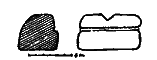
Fig. 26.Socket-stone.
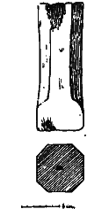
Fig. 27. Dial Shaft.

Fig. 28.Inner and outer jambs, north door.
The loose stones above described have been gathered together and placed in the Crosshouse at the south of the church-yard, opposite the porch.
Towards the west end of the north wall are remains, about 3 ft. 6 ins. high, of the jambs of a doorway, three feet wide, showing a hollow chamfer at the corner, 3 ins. diam. and 2,1/4 in. deep. Inside of the wall, which is here about 3 ft. 8 ins. thick, one or two of the corner stones remain, quite plain, and sharply angled to the splay ; the inside width of the doorway being 4 ft. 6 in.
One of the sand-stone ashlars in the south wall of the porch bears an incised circle, 5 ins. in diam. which possibly may have served as a dial, a small rod held to the centre would serve to act as a temporary gnomon.
The Font, set into the wall at the West end of the Church, is formed out of a fine boulder of coarse, dark grey grit or trap-rock, not met with in the Island. It measures 312 ins. long by 17 ins. at its deepest part, and has the Basin 23 ins. by 10~/4 ins. deep, with an outlet for the escape of the water. In the absence of any decorative treatment it is difficult to date it. Mr. R. Young informs us that there is one like it at Shankill, the original church of Belfast.
 Fig. 29. Font, Maughold. Photo D Kermode. |
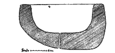 Fig. 30. Font, Kirk Maughold. Section. |
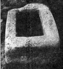
Fig. 31. Sarcophagus, Maughold Churchyard.
Photo. T. H. Midwood.
A stone Sarcophagus of a fine grey grit, very slightly dressed, was found many years ago near the N.E. corner of the church. It measures about 9 ft. 6 ins. long by a ft. 9. ins. wide and 15ins. high, the inside being 38ins. by 16 and Bins. deep. Round the mouth of it is a slight rebate from z ins. to aj ins. wide. This is now set near the stile leading from the Churchyard to the Head.
The famous Well lies a quarter of a mile N. E. of the Church, on the face of the cliff, about ioo ft above the sea. This is now a dripping well. the water percolating through the crevices in the wide jointed and shattered rock. The face here exposed is from three to four feet long and as much in height, and, on the rock-shelf below, a basin has been formed by the action of running water in the course of ages which constitutes the Holy Well; measuring a1 ins. long, rains wide,and from 8 t 10 ins deep, having at the bottom a smaller cup-hollow 6ins. by 4½ ins. On the north side a shelf of rock forms a boundary extending for 36 ins., while a south boundary is made by a great slab on edge built in with three courses of stone above it.
This rectangular recess is widened at its sea-ward end and retained by banks of earth, 3 ft. wide, faced with sto ies in courses, the floor being brought to a level end paved with heavy flags. Through this bank which is 4 ft. high on its sea-ward face, the water trickles away to the cliffs.
Until quite recently the Well was regularly visited on the first Sunday in August and offerings deposited consisting chiefly of small coins and crooked pins.
O.S. V, 16, (771).
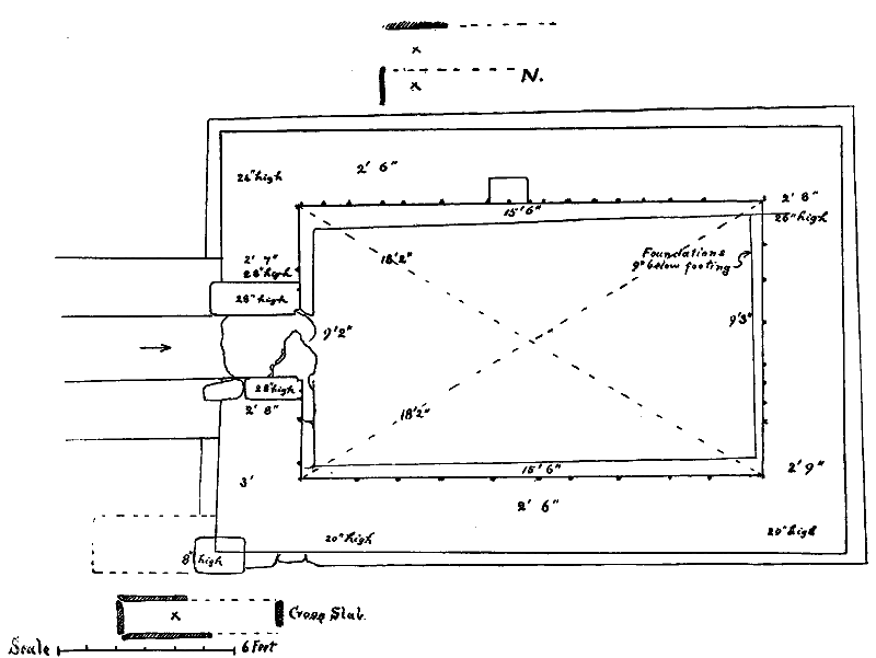
Fig. 32. Plan of North Keeill, Maughold Churchyard.
In the church-yard, at about 30 vards from the north wall and as much from the west, and at a height above sea-level of about zoo ft., are the foundations of a keeill measuring 15 ft. 6 ins. by 9 ft. 2 ins The walls, now about two feet high, are 2ft 6 ins. wide, well built of stone throughout, for the most part surface stones but mingled with some which have been roughly dressed with a hammer ; few of them exceed 20 ins long by from 5 to io ins. thick, but the outside corners have coigns of red sand-stone ashlars, about 13 ins by 9 ins. and from 7 to 8 ins. high. There are some dressed sand-stones also in the doorway about which are traces of rough-casting and a little lime-mortar. Inside and out is a footing projecting from 3 to 9 ins. from the walls. About the middle of the north wall, at a height above the footing of 8 ins. is an aumbry, or recess, 16 ins. wide by 12 ins deep and 15 ins high. Loose in this, Mr. Harrison found a carved piece of a window of red sand-stone which has now disappeared. About a dozen white pebbles were met with loose in the keeill, but no trace of the Altar or of the flooring remained. Some broken roofing slates of local rock (one being 14 ins. by 10 ins. and 1 z in. thick) with pin-hole for a wooden peg, would seem to show that the building had been still to use in comparatively recent times ; though it is possible that they had come from the parish Church and been thrown as rubbish into the ruins of this one. The most interesting feature was the doorway about the middle of the west end 22 ins. to 25 ins. wide, showing inside, a rebate of 2 ins. Its pavement is on a level with the footing, at which a northern jamb-stone of red-stone is about 8 ins. square by 12 ins high, with an outer one of tae ins. and 62 ins. high ; between and above these the wall is built up of thin slat stones from half-an-inch to an inch-and-a-half thick, till, at a height of 28 ins. it is crossed by a flag-stone 36 ins. by 13 and i z in. thick. The south side shows at the floorlevel, a sand-stone 1o ins. by 6 and 62 ins high, with one above about 6 ins. square ; the outer one of sandstone is 17 ins. by 12 ins. high, the space between filled with small slaty stones, above which it 1s built as on the other side with slabs up to an inch thick ; and, at a height of 28 ins., shows a flagstone 22 ins. by 9 and 3 ins. thick, with a smaller one outside of it. The ground outside is at a higher level but there are now no remains of a step or sill. On either side of the doorway we found remains of a projecting wall, 2 ft. wide, the foundations of which were traced for a length of 6 ft., forming a narrow porch-way. From the S.W. corner a buttress of the same width was found to project westwards for 4 ft.; both it and the other two walls which were well built of stone throughout being tied in to the walls of the building.
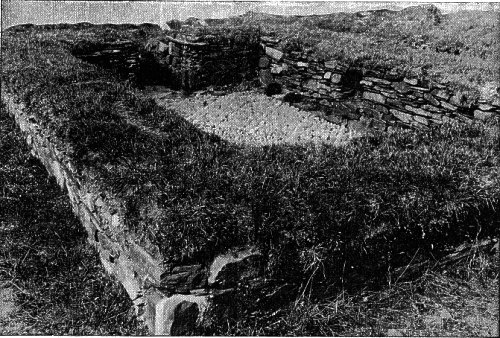
Fig. 33. View of North Keeill, Maughold, looking N.W.
This keeill was surrounded by its own little cemetery which had a southerly aspect. Though the fence had long been levelled we were able with the help of Mr. Harrison's memory of it to judge that it had mcasured about 51 yards N. and S. by 31 yards E. and W., crossing the moat, which formed its N.E. boundary. Lintel graves had been met with here as well as some not lined with stone, one of these, about 4 ft. below the present surface, was just outside the E. gable ; the cross-slab (Manx Crosses, to) formed the covering of another on the north side. This slab may date from early in the 6th century. At the S.W. corner of the keeill we came across anothergrave which had been previously disturbed ; at its east end was the broken cross-slab of twelfth century, described at a meeting of the Society.
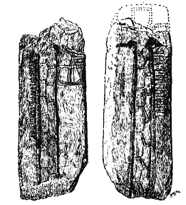
Fig. 34. Cross-slab from North Keeill, Maughold Churchyard.
To judge from some scribblings and scratchings on it, this must have been at the surface within a hundred years, but was lost again and unremembered over 50 years ago when Cumming described these monuments. It bears on each face a rudely-designed cross, and, in well-cut runes, the inscription, ' Hedin set this cross to the memory of his daughter [H] lif. Arni carved these runes ' It is of interest as showing for the first time on a Manx monument the figure of a Viking Ship. ,
At about 35 yards north of the east gable of the church, 228 ft. above sea-level, are the foundations of another keeill of rather different proportions. It measures about 19 ft. by i i ft. 6 ins. The walls now from 19 to 22 ins. high, are well built of stone throughout, apparently surface-stones and rather small, but some dressed with a hammer ; there is no trace of mortar ; they are from 24 to 30 ins. wide and have a footing outside and in, projecting about 6 ins. The doorway about the middle of the west wall is 2 ft. 9 ins. wide, paved with a large slab; the jambs are built in courses and two of the remaining jamb stones on each side are ashlars of sand-stone about 7 to 12ins. square by 6ins. to t2ins. high. Both floor pavement and altar had been entirely removed Thirty white pebbles were turned up in and around the building.
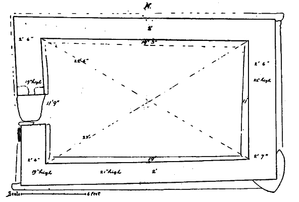
Fig. 35. Plan of Middle Keeill, Maughold Churchyard.
No boundaries of a separate enclosure can now be traced. "There was an appearance inside as of disturbed lintel graves. Just outside the keeill had been found the broken slab (Manx Crosses, 117.) bearing in Anglian runes of the seventh century the name [BLAK] GMON.
About ten yards N. W.. ' of the porch of the parish Church is the site of another Keeill recorded by 1\/1-r. Harrison, (Y. L. M., Vol. I, p. 384). Many white pebbles were found by us about this place, from which also had come the early cruciform slab of about the 7th century, (Manx Crosses, 45). The area being now occupied by graves was not disturbed by us. Mr. llarrison remembers remains of sod fences; these may have been on the lines of boundary of the old cemetery. It was known as the ' Church Croft'.
In the Manx Note Book, I, 66, Mr. Harrison recorded the foundations of a keeill discovered by him at the S.1-. corner of the church-yard together with traces of burials On excavating here, we revealed remains of walling of different periods, but, quite distinct in character from the rest, are the foundations of a keeill somewhat similar in the mode of building to the two last described. The height above sea-level would be about 200 feet.
At about 13 yards from the present eastern boundary of the church-yard, we came across the inner facing of stone to the strong embankment which formed the original boundary to the whole enclosure on this side. At two points about six and sixteen yards north of this, we found by excavation that it consisted of a dry stone wall, six feet wide and now reaching from the surface to a depth of two feet. Mr. Harrison remembered that it had had an earthen bank above and sloped into a fosse which came all the way from the north of the church-yard. South of the point where we struck it it had been broken into, but we were able to trace the inner line of it for four yards to the corner where it was met by another wall running west. This was at a point about 14 yards north of the present boundary wall ; only the foundations remained, they were 3 ft. wide, strong and well-laid. From the inner stone facing of this Eastern rampart, but not actually built into it, extended the northern wall of the keeill.
This is well-built of stone throughout, 2 ft. wide and now from 3 to 18 ins. high, with a footing inside and out. The stones are of fair size, many of them 24 ins. long and 3 to 6 ins. thick. others go through the wall having ends from 8 to 12 ins , to the face. The keeill measured about 21 ft. by l i ft.* The north end of the doorway remains in the west gable and is well built in courses, some of the stones being of the full width of the wall ; the south side is gone. The S. E corner of the keeill also has been broken into. Towards the east end appeared some rough pavement which may be original but no trace was found of the altar. Outside the north wall also is some very rough pavement similar in appearance to the paved foundations of paths found by us in the Burial ground on Skyhill. The foundations of the north wall, with the footing, are continued right on to the embankment but there is nothing to show to what height this would have been carried. Probably the south wall would have been continued in the same way but if so it is now removed from this point. Again at the S.W. corner the wall * Having made the Survey, the walls of the Keeill were raised to a level and turfed over for their better preservation ; the mouth of the well also has been surrounded by a low wall.
has been carried south for about 4 ft. apparently as a buttress. The foundations of the old south wall of the enclosure at this point would be distant about i i ft. from the keeill.
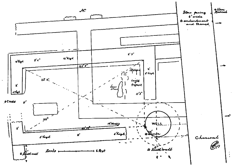
Fig. 36. East Keeill, Maughold Churchyard.
There is other walling, but of a different character, formed by stones, possibly taken from the keeill after it had fallen into ruins, with a great proportion of earth and not showing proper foundations There would seem to have been a building about 15 ft. by 13 ft., extending westwards from the embankment. The north wall of this building is continued for another ten or twelve feet where it is now broken. Smaller broken pieces may be contemporary with it.
Yet later, a Well had been sunk at the S.E. corner of the keeill, and breaking into that and the secondary walling also. Its mouth, now 2 ft. 6 ins. below the surface, was covered oy heavy stone lintels, and over 4 ft. in diameter. From this it was sunk for 7 ft. with walls of stone no doubt taken from the buildings, barrelshaped, with a greatest width of 5 ft. io ins. The walls are seen to have turned in at this depth, but, at some later date, the bottom was broken and it was sunk for another 6 ft., this lower part being underpinned with inferior walling and roughly rectangular. The present floor, 4 ft, wide, is flagged ; nothing was found on it but 12 ins. of mud with some stones which had fallen in.
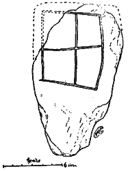
Fig. 37. Cross-slab,
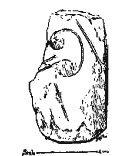
Fig. 38. Carved Fragment,
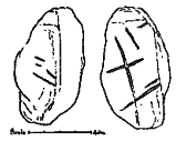
Fig. 39. Fragment, From East Keeill. Maughold Churchyard.
In the course of our excavations we came across a fragment which appears to have been flaked from off an early cross-slab It is of local clay-slate and measures 5 ins. by g ins. and i in. thick ; another carved fragment measured 8 by 4% ins. and Yin. thick. At the door was a slab 16ins. by Bins. and i 2 ins. thick, one face of which bears an incised plain linear-cross within a rectangular panel. A flat surface-slab, about 8 ins. square by 2 ins. thick, had an artificial hollow in the middle of one face as though for a socket (2IZ ins by 2 and Y4 in. deep). A larger slab was found with a similar hollow. A piece of sandstone, broken off a boulder and measuring 44 ins. by 3 ins. and i Y8 ins. thick, was artificially hollowed on each face, about 3 ins by i Y4 ins. and Y4 in. deep. This may have served as a lamp. About thirty white pebbles were met with and some wood-charcoal, and, lying loose, a good example of a small -Flint Scraper. This was of a dark horncoloured flint, about an inch in diameter and from Y8 to 5/,6 in. thick, with about a third of its edge rounded and chipped on one face. A flake of similar flint was also found.
At both places where we excavated through the embankment we found remains of Urn Burial about two feet below the surface and close to the inner face of the six foot walling. Mr. Harrison also found ashes near the southern corner where the wall had been broken into, and ashes have been met with at different places in the Churchyard.
|
|
||
| |
||
|
|
||
| Any comments, errors
or omissions gratefully received The
Editor HTML Transcription © F.Coakley , 2006 |
||