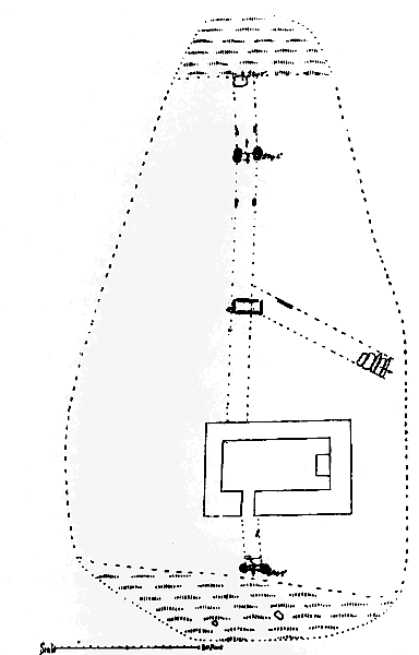
Fig. 1. Plan of Cemetery, Skyhill.
[From 4th Report - 1915]
TO THE ISLE OF MAN NATURAL HISTORY AND ANTIQUARIAN SOCIETY.
In our last Report we were anxious to complete, so far as possible, our account of the Keeills in the Sheading of Ayre ; but the remains still existing in the Parish of Lezayre had not then been actually examined by us. As a result of the excavations since made and of further inquiries, we have to make certain corrections, some of which are too important to be left over.
The total given in our List, of nine keeills or their sites is correct, for although two of these were subsequently proved to have been given in error, two others have to be added.
The structure on Skyhill, No. 3 on our list, though marked on the O.S. as Ruins of a Chapel,' was proved never to have been a keeill. By some people in the neighbourhood it is spoken of as a fort, and it would be in a commanding position as an outlook in the days of watch and ward. It is now being described and figured in the Proceedings of our Society.
The next site on Skyhill, our No. 4, marked 'Burial Ground' on the O.S., was also proved not to have been so. It is merely an outcrop of rock, which had been used as a deposit for field-stones, weeds and rubbish. The statement that lintel-graves had been found here evidently referred to the site a little to the South of it.
The other site marked 'Burial Ground' on O.S., V, 13 (2872), in the field called Magher ny hoarn, lies about 425 yds. S.S. E. of the Creg Bouvr. The pear-shaped area which now stands about 24in. above the field, the southern end being artificially raised to a level, contains a cemetery which was 23 yds. from N. to S., and over 16 yds, E. and W., measuring to the outside of its surrounding embankment, which was 6 ft. wide at. the base. *-See Plan, Fig. 1. An entrance at the south end is marked by upright stones 22 ins. apart, and a built step, 12 ins. high, between the inner stones from which a short, roughly-paved path leads to the door of the keeill, the foundations of which were discovered by us. The north end shows another entrance marked by a paving stone, 17 by 19 ins., and further inwards by large upright stones, one standing 36 ins., and the other 24 ins. above the ground, with a space between of 22 ins., and some remaining side-stones on edge; from this also, a path, very roughly paved with large slabs, leads to the keeill ; yet another path, similarly paved, leads diagonally from the east side to about the centre of the cemetery, but, if ever there were upright stones at its entrance, they have now disappeared. Almost in the centre was found a stone-lined grave of very archaic appearance. It measured externally 48 ins. by 23 to 24 ins., and w as 20 ins. deep, covered by two cap-stones, but not lined at the bottom. The slab on the N. side was 36 ins. long by 32 to 42 ins. thick, that on the S., 37 ins. long by I 2 to 2 ins;. the endstones crossed those of the sides and were respectively 19 and 20 ins. by 3 ins. The capstones measured 34 by 17 by 6 ins., and 31 by i i to 16 by 3 ins. Nothing was found within the grave.
* The north and south boundaries are clearly indicated by the remains of entrances, but the sides have evidently been encroached upon by the plough.
Fig. 1. Plan of Cemetery, Skyhill.
Of the Keeill, Fig. 2, the lines of the walls could be made out, though only two or three courses remained and some had been removed from the inner face, while many had slipped out of position. It measured 15 ft. by 7 ft., and the doorway was in the S. wall at a point 3 ft. from the S.W. corner. The lower jamb-stones remained, four or five thin slabs on each side, set on edge ; these had now slipped forward so that it was difficult to say what the original width had been, but it could not have been more than 21 ins. The W. end showed a skirting of slaty stones averaging about 13 ins. by 2 and 8 ins. high. At the E. end the base of the altar remained in the form of two heavy slabs, about 6 ins. thick, lying flat on the ground. The base measured 3 ft. 4 ins. by z ft. 2 ins. Outside there had been the usual bank against the wall as shown more distinctly at the S. E. corner.
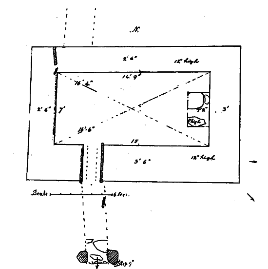
Fig. 2. Plan of Keeill, Skyhill.
Up the main stream of Glen Aldyn, about half a mile south of the bridge, a small holding on Ballagarrow, O.S., V, i4, 3113), is still known locally by a few as Keeill Phoogyn, Pooighyn, Pooghagh or Poogeraoh, possibly corruptions of the word 'Ooigyn,' literally 'caves,' but applied to early graves, as in Ooigyn Fawyr, Giants' graves, on Carran, Sulby. Graves, we were told, had been met with here in ploughing, but, except for the name there is now no other memoryof a keeill; possibly its stones are contained in the walls of the cottage.
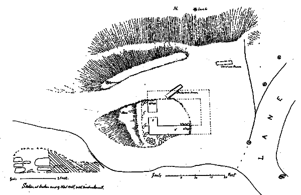
Fig. 3 Plan of Cemetery, Ballameanagh. Inset, Section of west wall.
In a field behind Mr. Cubbon's house in Glen Aldyn, are ruins still known to a few people as the 'Cabbal,' or the 'old Chapel.' This is in the enclosure marked V, 14 (3080) on the O.S., at a height above sea-level of 18o ft. or thereabouts. On a projecting bluff at the S. E. corner of the small field a portion of the ancient cemetery remains and part of the foundations of the keeill.
Fig. 3. A roadway had been cut diagonally through the building and many of the stones removed some thirty years ago. A few courses remain of the west and part of the South walls, about 24 ins. high. The dimensions appear to have been about 15 ft. by 9 ft. The bank against the S. W. corner was flagged with fairly large stones and there appeared to be traces of it at the N. E. and S. E. corners The exposed section of the West wall shows it to have had an inner and outer facing of stone filled in with soil and rubble ; about the middle of it were traces of the doorway. A few of the floor pavement stones remained in position. In the roadway cut across the Keeill, was found a well-constructed stone-lined grave running N. E. and S.W., the greater part of which must have been directly under the North wall, its highest part being quite 15 ins. below the level of the lowest foundation stone. It measured 6 ft. 6 ins. by 12 to 20 ins. wide and 24 ins. deep. Its south side was formed by two slabs overlapping for about 2 ins.; one of these was 5 ft. long by 24 ins. wide and 4 ins. thick, and its edge had been artificially worked to form a rounded hollow at its S.W end, 12 ins. across and 3 ins. deep ; the other was 24 ins. by 18 and from i to tins. t hick. The east-end stone, crossed by the side stones, was 12 ins. by 2 ins. One remained on the N. side, 4 ft. 6 ins. and 2 ins. thick ; the others, as well as the cap-stones, were missing. We were told that in making the road a bone needle and some rings had been found, but, unfortunately, they are now lost, and nothing was seen by us. There can be no doubt that it was a heathen pre-historic grave. East of the keeill is a fairly level triangular space about 9 yds. by 6 yds., in which graves had been found. One which we came across had been disturbed but was of very different character from the large one which was at a lower level ; its sides were lined by small slaty stones ; in it were over a dozen white quartz pebbles, a few of which also were met with in the keeill.
We learned that a mode of divination was formerly practised here by people curious to know who was to be taken during the ensuing twelve months. They visited the keeill on S. John's Eve and watched at midnight. One year twenty-one little lights came dancing up the glen ; it was the year of the 'great epidemic' and there were twenty-one deaths that year. In the North of England we find this practice in connection with the porches of certain churches, but generally on S. Mark's Eve or Halloween.
Our excavations here revealed the undoubted remains of the keeill from which it was evident that the site had been wrongly marked on the O.S.
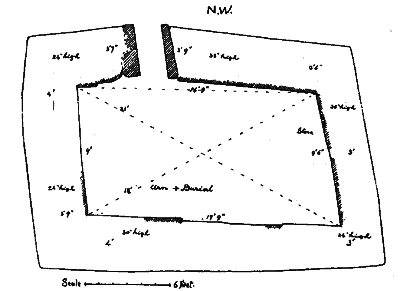
Fig. 4. Keeill on Corrody, Sulby, Lezayre.
It should be VII, 7 (3513), a little to the S. of that marked, and at the end of a piece of rough ground about 700 ft. above sea-level, rectangular in outline, about 120 ft. by 70 ft., running N.W. and S. E. This is still known locally as Cronk y Keeillee. The walls stand 24 to 40 ins. high and are from 3 to 4 ft. thick, the keeill measuring about 17 ft. 6 ins. by 9 ft; the orientation being almost due N.E. and S.W. by compass. The doorway, about 22 ins. wide, is in the North wall at 4 ft. 6 ins. from the West corner. The large upright lower jamb-stones remain, that on the W. 24 ins, square and 24 ins. high, with another outside 20 ins. long by 9 ins. and i t ins. high,; the E. jamb is a heavy slab: 45 ins. by 40 to 43 ins. high and from 7 to 8 ins. thick One or two of the floor pavement-stones were in position, but the altar was ;one. The lower courses of the walls inside had a skirting of large ston-,s on end; seven, besides the doorposts on the north, averaging 22 ins. by 222ins. high, and 3 to 4 ins. thick and on the E. two of 27 and 37 ins. high and four others averaging only about i i ins. at its S.W. end.
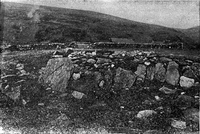
Fig. 5. Walls of Keeill, Corrody, showing stone skirting.
Under the floor of the keeill at its S.W. end, was found the urn mentioned in our footnote, 3rd Report, p. 37, and since figured in the Seventh Report of the Manx Museum.
The Keeill had been set on a low and partly artificial mound, now two feet above the level of the field, roughly circular but here and there encroached upon by the plough, and having an inside diameter of about thirteen yards; surrounded by stones set on end with remains of an outer circle of stones at 3 to 6 ft. from the other. The largest of these stones was at the E. end and measured thirty two inches high above the surface of the ground by 22 to 24 inches. The general appearance suggested a pre-historic burial-place, and the cinerary urn now found proved it to have been used as such in the Bronze Age before it became a Christian Cemetery.
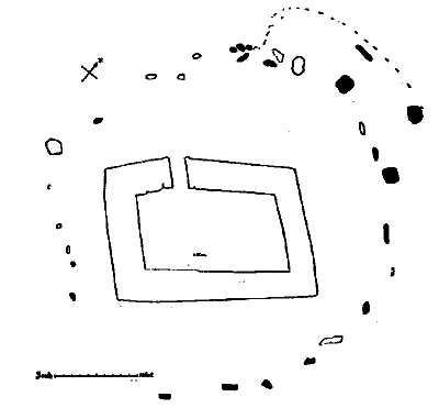
Fig. 6. Plan of Keeill and Circle, Corrody.
|
|
||
| |
||
|
|
||
|
Any comments, errors or omissions gratefully received
The Editor HTML Transcription © F.Coakley , 2006 |
||