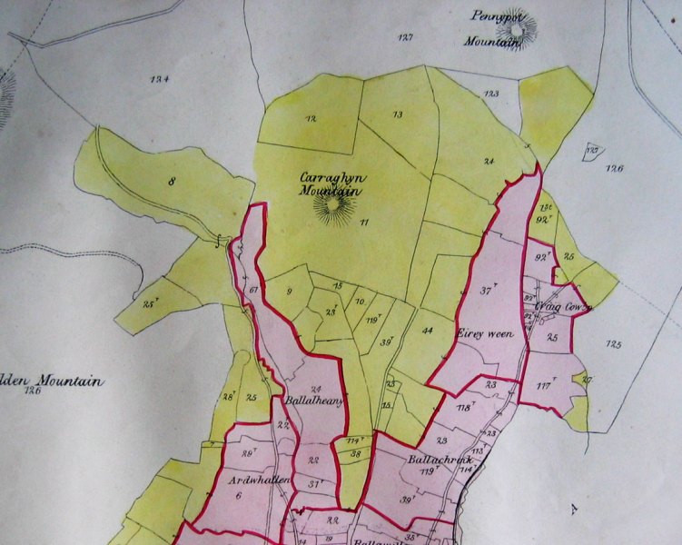
FIGURE 1. Part of the Braddan plan from Woods's Atlas (Reduced).
N. G. Crowe, B. Sc., A. R. I. C. S.
This paper is the result of research carried out in connection with the Society's treen boundary survey. It addresses the sources of the topographical information from which previous treen maps have been prepared, and explores the background to the compilation of Woods's Atlas.1
The treen is believed to be a Celtic land-division, and ranges in size from less than 200 to more than 600 acres. It is often bounded in part by natural features. The quarterland is a sub-division of a treen, generally one-fourth, and until the nineteenth century was generally held by a farmer by customary tenure .2 Treen boundaries were comprehensively delineated in William Cubbon's The Treen Divisions of Mann published in 1930.3 The same maps had already appeared, at a smaller scale and uncoloured, in J. J. Kneen's books of place-names.4 Kneen's preface paid tribute to Cubbon's work: "The maps have been carefully prepared and reproduced from plans which are the results of many years' painstaking labour, and it is the first time the treens or ancient tribal divisions of the Island have been published". These maps were based on hand-annotated and coloured copies of a set of Ordnance Survey six-inch sheets which still exists.5 Cubbon wished his indebtedness to Woods's Atlas, published in 1867, to be acknowledged.
Elwyn Davies, in preparing his 1956 paper on treens and quarterlands,6 noted up another set of six-inch sheets, which cannot presently be located. These were the basis for the small-scale mapping in his paper. Like Cubbon, Davies drew extensively on James Woods's publication. He explained:
Although Woods's maps do not show field boundaries or minor topography, they are accurate enough to make it possible, with some local knowledge, to trace the boundaries of the quarterlands on the Ordnance Survey's six inch map, and the treen boundaries can then be arrived at by the aggregation of the appropriate quarterlands.7
Davies went on to confirm that it was on such a transposition and aggregation that his study was based. Statistical data in the study were also derived from the same source. The invaluable publication on which Cubbon and Davies drew was compiled by the local surveyor James Woods from at least 1864,8 and appeared in 1867. The Atlas comprised seventeen hand-coloured maps, one for each of the Island's parishes (Fig. 1). A number of scales were adopted, depending on the size of the parish. Each map identified the extent of individual landholdings, and named most of the quarterlands. The printed base maps indicated the boundaries between land of different manorial descriptions, or belonging to different quarterlands, within individual holdings. The hand colouring accentuated the distinction between lands of different manorial descriptions; Lord's quarterlands, for example, were tinted pink, while intacks were yellow.9 This enabled the broader tenurial distinctions between various parts of the parish to be appreciated. Finally each quarterland was outlined in red ink.
The gazetteer for each parish (Fig. 2) was linked to its map by reference numbers specific to each of the individual holdings. Much of the tabulated information derived directly from the manuscript schedules" containing the valuation of property for the purposes of the Asylum Act 186010 (Fig. 3). This valuation established the rental value of property throughout the Island, in order that a rate might be levied to finance the proposed lunatic asylum. In the Atlas, each table set out the names of landowners, with the manorial description of their lands. The total acreage of each holding given in the asylum valuation was broken down, if necessary, where land of more than one description was included. The details of tenancy or occupation were omitted. The reference number for each holding was also derived from the valuation schedule, and indicated the individual scale plan deposited in the Rolls Office.
James Woods had good reason to be familiar with the asylum valuation records, as he had been appointed Surveyor under the Act in 1861.12 It was undoubtedly the knowledge of Manx property gained through association with the asylum valuers and their records which enabled Woods to undertake the Atlas. In the process of his work for the Asylum Board, he also referred constantly to another series of plans deposited in the Rolls Office, those compiled some twenty years earlier for the assessment of the tithe rent under the Tithe Commutation Act. 13,14,15
FIGURE 1. Part of the Braddan plan from Woods's Atlas (Reduced).
|
TREEN, &c.
|
NAME OF QUARTERLAND,
OR NO. OF INTACK. |
NUMBER
ON PLAN. |
PROPRIETOR.
|
EXTENT
IN STATUTE MEASURE. |
|---|---|---|---|---|
|
A. R. P.
|
||||
| Ballaregnelt | Part of Ballachrink | 114 T | Robert Quiggan |
5 3 17
|
| Intack | Part of No. 53 |
5 1 24
|
||
|
11 1 1
|
||||
| | Part of No. 32 and 54 | 23 | John W. Cowin |
15 0 39
|
| Ballnregnelt | Part of Ballachrink |
30 3 35
|
||
|
46 0 24
|
||||
| Intack | Part of No. 32 | 118 T | John W. Cowin |
15 3 32
|
| Ballaregnelt | Part of Ballachrink |
26 3 10
|
||
|
42 3 2
|
||||
| | Part of Eirey Ween | 60 T | Thomas Hampton |
2 1 16
|
| Intack | Nos. 28, 48, and part of 54 | 44 T | John Cain |
61 1 12
|
| Ballaregnelt | Part of Eirey Ween |
22 3 12
|
||
|
84 0 24
|
||||
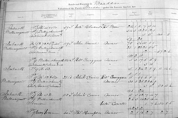
FIGURE 3. Braddan asylum valuation book. (Reproduced by kind permission of the Manx National Heritage MD902/1 [MS09309])
Although the processes of valuing land for the purposes of these Acts must have been almost identical, there was an interesting difference in the information required to be provided by the valuers. Section 5 of the 1839 Act directed the valuers to "make a true valuation and estimate; distinguishing each parish, the name and description of the several lands, and the names of the proprietors and occupiers thereof . . .". The 1860 Act was more specific: Section 2a required
That the said valuers in making the valuation of land, shall distinguish the parish in which the land is situate and shall describe the quarterland by its name and the Treen in which it is situated and the Intack and Cottage land by its number ...
In any research required for this work the valuers could be assisted by the Setting Quest and Moar of each parish." The Quest was a parish jury drawn from the principal land-holders responsible, amongst other things, for reporting changes of tenant to the Court Baron, and for apportioning Lord's rent.17 The Moar collected the Lord's rent.18 The task facing the valuers and those assisting them was simplified by a recent improvement in the manorial records. The year 1858 had seen the compilation of a new volume of Liber Assedationis, the Lord's rent roll; the first to be compiled since the English Crown had acquired the manorial rights in 1828.19,20
When the plans prepared under the Asylum Act are examined, it can be seen that different quarterlands are usually identified in the table setting out the acreages of the parcels .21 Intack land is also usually distinguished from quarterland. By contrast the plans deposited under the Tithe Commutation Act, which were not compiled against a statutory obligation to distinguish between intack, quarterland or cottage rent, are far less informative in this regard. 22 A reason must be sought for the additional requirement for detailed information on the manorial status or description of land incorporated into the Asylum Act. The valuers did not need such detailed information on title in order to arrive at the annual value of a property, and a plan identifying the extent and provided with a table of areas should have been all that was required.
Two cases litigated in the 1850s turned on the distinction between quarterland and intack. The first, known as "the Kella Case" covered the settlement of the estate of John Corlett junior, of East Kella, Lezayre.23 He died in 1849,24 possessed of the estate of East Kella, consisting of both quarterland and intack, and various other purchased lands. His executor, James (later Sir James) Gell, advocate, found the personal estate was insufficient to pay Corlett's debts. The will had authorised the sale of certain purchased properties to pay off debts, but these were insufficient. Gell applied to the Chancery Court to authorise the sale of the inherited intacks, some of which had become merged with the quarterland. It was necessary for the Governor, Charles Hope, sitting as Chancellor, to refer to a common law jury the question as to the boundary between quarterland (which could not be sold) and intack. The jury was satisfied that a length of old road (which had been partially diverted) formed the boundary between the areas of quarterland and intack comprised in the holding. There was difficulty though in finding out the manorial description of the old roadway itself. This proved crucial because while the old dwelling house on the farm stood on the quarterland of Balnahawin, the new dwelling or mansion house of the East Kella had been constructed largely on an easement which was part of the roadway in question. On a second reference the jury determined that all but a corner of the new house stood on quarterland.25 This case surely brought home to advocates landowners and unsecured creditors the importance of establishing whether farms were quarterland or intack in assessing credit-worthiness. It must also have been obvious from the nature of the evidence sworn before the court, that in the wake of agricultural improvments involving removal of old field boundaries and diversion of roads, it would soon become impossible to resolve such issues. The estate of John Corlett junior was finally settled, following the relevant sales, in around 1856.26
The Asylum Bill was drafted in October 1858 by the Attorney General C. R. Odgen, at the direction of Charles Hope ,27 who had presided over the Kella case less than three years before.28
Another important case which raised issues concerning the relative status of intack and quarterland was before the Manx courts at the very time that the Asylum Bill was being considered by the Legislature. This was Teare v. Quirk 29 and involved Richard Sherwood, who acted for the appellant. Sherwood urged a distinction between "intacks of ease to quarterlands" which he reckoned to be properties of heirship, and other intacks, which were not. Such a distinction would prevent the dismemberment of his client's late father's estate near Sheau Whallian. It was contended that the fences on the property had been thrown down, and it was doubtful whether the quarterland could be distinguished from the intack. Sherwood asked the House of Keys to decide for the appellant and thus abolish a difference in tenure which could only act to disfigure a family estate. The majority of the House were not persuaded by his logic, and the appeal was dismissed.30 Despite this, Sherwood pursued his thesis at great length in his manuscript account of Manx land law, seemingly written not long after this disappointment.31
The first indication that James Woods intended to publish the information gathered during the asylum valuation in the form of an atlas came in December 1864, when a long-running newspaper advertisement first appeared.32 This indicated that a copy of the atlas (presumably the original manuscript) was available for inspection. Publication took place in July 1867, and the preface acknowledges assistance given in its compilation, including that of John Thomas Clucas and Richard Sherwood.33
It is ironic that within two years of the publication of the Atlas the partially reformed Legislature was discussing measures to abolish the legal distinction between quarterland and intack. A bill which was under consideration in 1868 provided that all land of a deceased property owner could be made available to pay his debts.34 Another provided that all real property of whatever description could be devised by will.35 During the clauses stage, the Council attempted to vary the latter provision by protecting the automatic right of the heir-in-law to property acquired by descent. G. W. Dumbell was intent on reforming this aspect of the law and stated that the Keys had decided this question three times and he supposed they could have no difficulty in deciding it a fourth time ... The House had asked for a useful and valuable measure of reform ... for a little more latitude for the property owners of the country, and said "don't tie up a man as to the proper disposal of his property". They should not be tied and fettered by a parcel of lawyers making deeds of sale and resale so that a man may dispose of his property ... Even by the present state of the Law a man has power to devise by will all his real property except that around which a halo is cast - quarterland of inheritance .36
W. F. Moore threw light on the difficulties which lawyers and landowners had experienced:
... it was most desirable that there should be no distinction whatever with regard to quarterlands, intacks and other property. The Hon Members . . . must be perfectly aware that it was almost impossible to distinguish intacks from quarterlands. In many instances they were so mixed up that to distinguish them was a matter of impossibility. 37
Revd. W. B. Christian touched on another reason for the desired reforms, to free up the market in land:
... when property was sold it was very difficult to get a purchaser from the other side of the water, because Manx titles were so very intricate ... that English lawyers would not look at Manx property ... Many (landowners) had occasion to mortgage their estates, and unquestionably they had to pay a higher rate of interest, because English money did not freely come into the Island ...
The reform measures were passed into law in 1869.
The 1860s saw a unique conjunction of circumstances. First there was a demand for a comprehensive survey of land holding, driven by the complexity of the Manx land tenures, and the increasing professionalism of the Manx bar. Secondly, means were found to insert a requirement for tenurial information into the valuation provisions of the Asylum Act. Finally support must have been forthcoming to finance James Woods in whatever preparation work went beyond his official duties, and to pay for advertising and printing.
Shortly after publication reforms rendered much of the information in the Atlas redundant for litigation purposes. However, since that time Woods's work has retained a place in every advocate's office, and as we have seen has also been drawn upon by historians. To Manx genealogists it is an essential tool of research.38
All acts are Acts of Tynwald
1 Woods, James, A New Atlas and Gazetteer of the Isle of Man (London & Isle of Man, 1867).