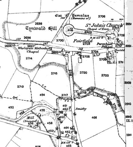
St John's is a small village near Tynwald Hill and its associated church of St John's - the road running east to west is the main road (now the A1) from Douglas to Peel that follows the central valley; the road heading south is that to Castletown via Foxdale, whilst that heading north passes Tynwald mills and leads onto Ramsey via Kirk Michael.
The fair field, Tynwald hill (strictly an artificial small mound) , the ceremonial pathway and the Church are the key features - the they sit on a small gravel plateau that falls away quite steeply towards one branch of the Neb which runs down from Foxdale which forms the basis of the boundary between Patrick on the south and German on the north, another branch is just off map running down North East to SW - the main road crossing at Ballaleece bridge. The Inn at the cross roads was common stopping point for the 19th Century tourists - a parochial school was established just south of the church (building still in use as the church hall - a later school built early 20th Century on the south side opposite the fair field (now the Manx Language school) was replaced a few years ago by a more modern school on a site previously used by the railway (field 466).
The 1868 plan predates the arrival of the railway - St John's was the junction between the Douglas-Peel and the Manx Northern Railway from St John's to Ramsey and the slightly later Foxdale branch built to service the mine - the various stations were built to the south of the main road in the field 466 on the plan.
|
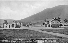
The c. 1900 postcard shows a very quiet St John's looking south from Tynwald Mount. |
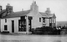
Opposite the Tynwald Inn was the much older building, originally thatched, then the local Post Office |
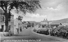
Another early 20th Century postcard shows the village looking north towards Tynwald Mount (the Tynwald Inn can be seen mid background) from where the road from Kirk Patrick south of the Neb meets the Foxdale road. The view shows the newly built Farmers' Arms (behind which was a yard for livestock sales) the level crossing with a bridge over the railway tracks. Apart from two houses the development is post 1868. |
There is a Wesleyan Methodist chapel dating from 1824 in a waste corner of the field at the westward edge of the village - a much larger chapel was later erected opposite to St John's church.
|
|
||
|
|
||
|
|
||
| Any comments, errors
or omissions gratefully received The
Editor © F.Coakley , 2012 |
||