Or how to find that elusive Balla...
There are some 600 'Balla's on the Island - Balla is the most common prefix for a placename and derives from Balley (Irish Baile) 'a homestead'. It would appear that these family units were once synonomous with Treens - in the earliest Manorial rolls they are described as Lands. However with increased population, subdivison and reclamation of waste land these treens were divided into quarterlands and the term Balla tended to refer to these quarterlands. These quarterlands may now contain more than one farm - which may themselves be called 'Balla...' though usually referred to as part of the containing quarterland.
The source generally used in the derivation of the name is J.J.Kneen's The Place Names of the Isle of Man first published in 1925 - this being organised by Parish means that one has to either know the approximate location or suffer a tedious search. Accordingly these pages are organised in alphabetic order - under each name will be found the parish and usually a Grid Reference. This grid reference refers generally to an associated farmhouse or group of buildings but sometimes to the approximate centre of an area.
Note the spelling of Manx names was still somewhat changeable even as late as the 1881 census - Ballacrink/Ballachrink for example. I have generally adopted that suggested by Kneen though sometimes the 1881 census reverts to an earlier form. The 1881 census was chosen mainly for its convenience and it was also towards the end of my period of interest (pre WW1).
The general form is:
[ref] (gridref) type - [ref]
is shown as [Kn] if name was not mentioned in 1881 census,
[1881c xxx] if 1881 census had a different form than that
suggested by Kneen or =xxx if listed under the 1881 form and Kneen
had a different spelling. For type see below
Historical refs - M.R. = Manorial Roll Kneen appears to have followed
Talbot's reading of the earliest
1511/1515 rolls.- for others see under Abbreviations
Discussion - generally taken from Kneen
Additional information & links to other relevant pages on this
website
Included here as a convenience:
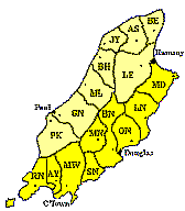
|
North Side |
South Side |
|
||
|---|---|---|---|---|
|
PK |
RN |
|||
|
GN |
AY |
|||
|
ML |
MW |
|||
|
BH |
SN |
|||
|
JY |
MN |
|||
|
AS |
BN |
|||
|
BE |
ON |
|||
|
LE |
LN |
|||
|
MD |
||||
Note in 1796 Onchan was removed from Garff and added to Middle; at the same time Maughold was listed under the North rather than the South Side (where common usage and feeling still puts it 200 years later!)
J.J. Kneen The
Place-Names of the Isle of Man with their origin and history
Douglas: Yn Cheshaght Ghailckagh (The Manx Society) 1925 (reprinted
1975)
A.W. Moore The Surnames and
Place-names of the Isle of Man London: Elliot Stock 1890
A.W. Moore Manx Names, or The Surnames and Place-Names of the Isle
of Man, with a Preface by Professor Rhys. 2nd ed revised London:
Elliot Stock 1903
W & C. Radcliffe A History of Kirk Maughold Douglas: Manx
Museum and national Trust 1979
T. Talbot The Manorial
Roll of the Isle of Man 1511-15. Translated from the Latin
by Theophilus Talbot with appendices and indices London: Humphrey
Milord 1924
James Woods A New Atlas & Gazeteer
of the Isle of Man Ramsey: 1867
Ordnance Survey 1:50,000 Isle of Man Landranger series
#97
1:25,000 Isle of Man Public Rights of Way and Outdoor Leisure
Map Douglas: Department of Local Government and the
Environment
|
|
||
|
|
||
|
|
||
|
|
||