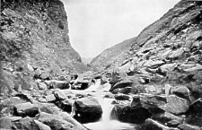
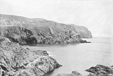
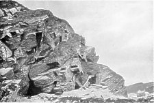
Pass of Glen Meay
[From Mate's Isle of Man Illustrated, 1902]
Pass of Glen Meay
GLEN RUSHEN, comparable to Sulby, lying on the N.W. side of South Barule, winds north and finally W. entering the sea three miles south of Peel. The last mile of its course is Glen Meay. The descent is perilously steep to the bridge beside the mill, a most picturesque nook sheltered from all winds. On the Dalby side is an old horse-path with steps worn in the rock between high banks that do not admit of two horses passing.
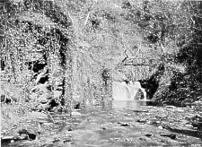
In Glen Meay
Below the mill the river course is a deep canon with small cascades and pools ending at a fine, fall. The steeps are planted with larch and fir. The gorge, seawards, is also very fine. This is the Pass of Glen Meay, in loneliness and solitude one of the choicest places on the Island. Road and river descend between rugged crags, 200 feet high, to a shore under Knocaloe Hill. Several small ruined churches and borranes (or earth forts) are in this locality, the forts towards Dalby. The sea-board slope, southwards, constituted a barony belonging to the Irish Abbeys of Bangor and Sabal in Down. A fine cross, much earlier than the runic crosses, can be seen at Ballelby Farm, taken from the traditional site of the barony church. At St. James' Church (modern) the road turns inland. Here the coast view of Cronk-ny-Arrey-Lhaa (Hill of the Day Watch), Bradda and the Calf is admittedly the finest coast prospect on the Island. A deep valley, Dalby Lagg (hollow), lies in front, and the road turns round the head of it, but the old road that crossed the Lagg is seen on the side of the opposite hill ascending on the bare rock.
From the Lagg the road strikes S.E. across the moors to the Round Table, the col between South Barule and Cronk-nyArrey-Lhaa. South Barule is a heathery dome with an immense pre-historic stronghold on its summit, trench and rampart of rude masonry, overgrown with luxuriant heather. Barule, Wardfell, or Watch Hill, had a beacon in old days visible from Peel Castle and Castle Rushen : and a signal flashed from castle to castle in a few moments. From South Barule the southern half of the Island lies spread out like a map under the eye. The descent ends at Rushen Parish Church -Holy Trinity, Inter Prata (among the meadows), a mile from Port Erin. The church, re-built 1770, is of the Manx type, and like the older churches, is whitewashed. From this point the structure of the country may be noted. Three isolated hills, outliers of the mountain range, form the south-west end of Man. Bradda is the first, separated by the gorge of Fleshwick, opening north on Fleshwick Bay, looking towards Dalby and Peel. Between Bradda and the Mull Hills (or hill), looking westward, is Port Erin ; and beyond the Mull Hills is the third of the group, the Calf Islet, separated by the Sound.
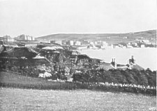
Calf of Man from Bradda Head
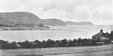
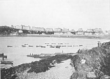
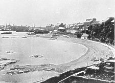
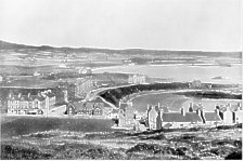
Port Erin from the South
PORT ERIN Bay, half-a-mile wide, comes deep into the land between headlands, 400 feet high. On the right, looking sea- wards, on the brow of Bradda, is Milner's Tower (1871), a monument to Mr. W. Milner,of Milner's Safe fame, who gave an impetus to the development of Port Erin as a watering-place. At the base of the head, accessible only by water, are Bradda Mines, and around the head, seawards, are other mines accessible by a precipitous miners' path. The whole hill is honey-combed with workings, some of unknown antiquities.
 Port Erin |
 Bradda Head, Port Erin |
 Port Erin |
 Bradda Head and Breakwater |
On the south side of the bay is the approach road and breakwater intended to make Port Erin a harbour of refuge. The work cost £670,000, but has been much injured by the sea. It is now a mere tidal reef. The destiny of Port Erin was to be a watering-place. It has a charming shore and delightful surroundings. The arrangement of Port Erin is a range of older and smaller houses at the very base of the scarped banks of gravel, fronting on the beach and overlooking them a beautiful high-level promenade, with modern hotels and boarding houses. Sea-fishing, bathing, golf, mountain excursions, and the roamage of the headlands constitute the programme of the visitor. The Railway Station is the terminus of the Douglas, Castletown, and Port Erin Branch of the Isle of Man Railways, and a morning train leaves in connection with the steamers from Douglas to Liverpool, Barrow, and Fleetwood.
![Craig-Neash [Cregneish]](zp093.jpg)
Craig-Neash [Cregneish]
A FOOTPATH from Port Erin leads over the Mull Hills, with magnificent sea and mountain views, to Crag-Neash, the Sound, and the Chasms. Crag-Neash is the most primitive place in Manx-land. It is a little village of thatched cottages, where both Manx and English are spoken. The people are fishermen, who go to sea from Port St Mary. The Calf is a treeless sweep of grassy plateau, on the crown of grey slaty cliffs - the landing-place being the Sound. Its area is about 600 acres. and is held by a tenant as sheep- farm and rabbit-warren ; the farm buildings and disused lighthouses being on the seaward side. West of the Calf is the Chickens Rock, with lighthouse, erected 1875, one of the finest on the coast of Great Britain. The Calf has a ruined chapel, with an exquisitely designed cross, belonging to an early Celtic Mission cell. In the 17th century, a recluse, named Bushell, spent some years in a voluntary exile on the Calf,-which suggested to Mr. Hall Caine the concluding episode of " The Deemster."
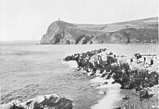
Spanish Head
From Crag-Neash, southwards, along the heights, is a path to Spanish Head, formerly Esparolet. There is the usual tradition of a ship of the Armada having been wrecked here. Between Spanish Head and Port St. Mary are the Chasms, immense fissures in the tilted up slate strata, due to the undermining action of the sea at the base of the cliffs. Further on is Fistard and Glen Chass, a fishing hamlet and decayed lead mines, overlooking Perwick Bay.
 Port St Mary |
 Port St Mary |
 Port St Mary |
THE PORT," "Port-le Murra," or Port St. Mary is' par excellence a fishing town. It is to this district what Peel is to the northern and middle districts of the Island. It, too, is exceedingly picturesque. Its prevailing tints are grey, from the limestone and slate. " The haunt of the artist and the pleasure seeker," say its admirers. It is certainly very much painted. Across the inner bay is St. Mary's Well and the site of an ancient chapel attached to Rushen Abbey. The station is half-a-mile from "The Port" and a mile from Port Erin, on the road to the parish church. Either of three routes may be taken to Castletown, viz. : the coast, the railway, or the inland road past Rushen Church, and through Colby and Arbory. The coast road skirts Port St. Mary Bay. The railway lies all the way through fertile flats with stations for Colby and Arbory. Near Colby is Bell Abbey, once a Grange of Rushen Abbey. Colby is a most picturesque hamlet extending from the bridge into a beautiful wooded glen, with characteristic Manx cottages and farmhouses, and a delightful old mill. A mile beyond Colby Bridge is Arbory. The church, re-built 1772, is dedicated to St. Columbia of Iona. It conta;ns fragments of carved oak panels of 16th century, from the older church. St. Columbia (died 597) and the family of Iona have left the traces of their missions to Man in four principal dedications of churches, viz.: Arbory, Malew, Marown, and Lonan. The road from Arbory leads, to the left, direct to the Round Table, the main road turning to the right to Castletown. Immediately after the turn is the Friary, now a farm, formerly called Bemecan, and a house of Franciscan Friars. The chapel (1375) is all that remains of the old buildings : and is now a cattle shed. It is two miles to Ballasalla : and midway, near the crossing of the great high-road from Ramsey to Castletown, is Malew Church, dedicated to St. Lua, a Columban Bishop, companion of Columba, and founder of the church at Lismore. The chancel and transept are modern, but the nave is very ancient, not improbably dating from 10th century, its distinctive features much obscured by the alterations of the Church. A few mutilated runic crosses at Malew survived the religious vandalism of the monks of Rushen Abbey to whom the parish and church belonged for four centuries. Ballasalla is on the Silverburn, which rises in South Barule, near the Round Table, and enters the sea at Castletown. The village (Balla St. Lua) is on the east, and the Abbey on the west bank of the river, embowered in fine timber, the elms here attaining a larger size than elsewhere on the Island.
THE remains are not considerable. A square bell tower shows the situation of the church which stood north and south. Its roof and an arcade were transferred to Castletown after the reformation : for a church now became the Grammar School. A picturesque dove-cot tower and the refectory stand beside the river ; and a vaulted cell, seemingly a fragment of a cloister, stands farther back a little distance south of the church. There is also a postern gate and guarding tower on the side farthest from the river, suggesting an arrange ment on the plain of F u rn e s s Abbey, of which Rushen was a branch. The Abbey was granted by Olaf I. (1134) to Furness, with the patronage of the diocese founded at the same time. It was on the site of an older Monastery of St. Leoc (or Lua), an i had its origin from the Columban Missions of Iona. Bishop Symon, Olaf II., and Magnus, the last King of Man (died 1265), are buried in the Abbey ; but the only sepulchre monument is a sandstone slab carved with a central cross and a sword along one side, conjecturally of 13th century.
A little way up the Silverburn is Crossag Bridge, or the Monk's Bridge, a curious, narrow, high - pitched structure of threepointed arches, dating conjecturally from 12th century. The Silverburn is a beautiful valley, more open than is usual with Manx Glens.
A local industry is the manufacture of flaked oats with a nutty flavour, preserved by a process of drying the corn on a tiled kiln.
Ballasalla has a station on the Castletown and Douglas line. There is a choice of routes, by road past Malew or through the fields east of the river, past the College ; by the river-bank path ; or by train.
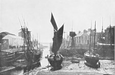
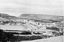
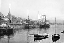
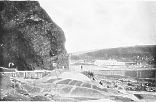
Castletown Harbour
CASTLE RUSHEN stands by a tidal pool on the west bank of Silverburn, from which the river has cut a narrow channel to the sea, through the horizontal limestone beds which constitute the geological structure of the district.
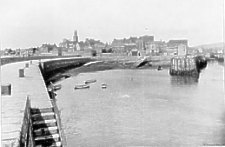
Castletown from Breakwater
The town is a half-moon round the landward side of the Castle, the tidal pool being its harbour.
![The Market Place [Parade], Castletown](zp084.jpg)
The Market Place [Parade], Castletown
The Parade is an elegant oblong piazza overlooked. by the Castle Keep, with two main streets leading north and west, continuous with the Ramsey and Port St. Mary roads. The ancient capital is a perfectly charming town, the prevalent tint a quiet grey, but it has a deserted air redolent of -
the pride of former days
And glories that are o'er.
The railway does not disturb its quiet but passes outside the town with a station half-a-mile from the Parade. The residence of the Governor and other officials, the Law Courts, the House of Keys Chamber, the Gaol, - everything has been transferred to Douglas. There remains, however, the Castle, permanent as time itself.
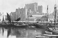
Castle Rushen and Harbour of Castletown
THE Castle is not a ruin ; has not a trace of dilapidation ; its angles all sharp ; but its limestone hard as adament has whitened a little, so that its tones vary from pearl through many shades of grey to a shadowy blue. The first mention of the Castle is by implication in 1257, when Magnus abandoned St. Patrick's Isle to his Bishop. That he built or extended it is certain. Robert Bruce captured it after a six month's siege in 1313. The Lieutenant-Governor, Henry Byron, held a Tynwald here in 1422. Opinion is divided as to the date of the central keep, some holding that it is of the 14th century, when the Earls of Salisbury were Lords of Man. It was more probably built in 15th century, in the York and Lancaster time, by the Stanleys devoted to the Lancastrian cause. The Castle, since it ceased to be a gaol, has been more freely opened for inspection, and has also a small museum of antiquities, including a magnificent skeleton of the Manx elk.
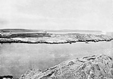
Near Castletown, at the west end of the bay, is Scarlett Stack, a dome-shaped boss of basalt, accessible at low water. At this point the remains of a geological volcano break up the limestone beds, and there are fine examples of glacial action on the surface of the limestone. Across the bay, eastwards, is Langness.
Half-way round the bay is the small tower of Hango on an artificial mound, part of which has been broken away by the erosion of the sea. The tower dates from the Stanley period ; the mound is a pre-historic burial cairn. This was the place of execution of Iliam Dhone, January 2nd, 1662. It is visible from Ronaldsway windows across a mile of level fields. On the landward side of the road is King William's College, a fine block with central tower, chapel, and sanatorium apart at intervals to the right ; gymnasium, laboratories, workshops, baths, etc., to the left. It is a public school with an excellent record in University and other laurels. In the roll of its alumni are Dean Farrar, Archdeacon Wilson, Sir William White (diplomatist), General Sir George White, of Ladysmith fame, and the Rev. T. E. Brown, Manx Poet and Humourist. This school is the scene of - Eric," Dean Farrar's popular story of school life. "There are memorials of the Rev. T. E. Brown in the chapel. His residence was Ronaldsburn House on the shore of Derbyhaven Bay.
THE isthmus, joining Langness to the main Island, is the old race-course of the Stanley times. It has fine sward, sand pits, and clumps of gorse : and is laid out as a golf course. Langness is a long, narrow, and not a very high ridge of slate, covered with soil and sparsely cultivated. It extends for four miles nearly parallel to the coast, its westward arm enclosing Castletown Bay, its eastern, which terminates in St. Michael's or Fort Island, enclosing Derbyhaven Bay.
The scene of " Betsey Lee " is Derbyhaven, which is also the locality of Hesba, Stretton's story, " The Fishers of Derbyhaven."
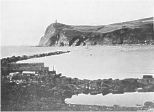
Fort Island from Langness
Fort Island is joined to Langness by a military causeway. At the causeway end of the islet is the roofless Church of St. Michael on the unfenced seableached sward, the earthwork and the graves now scarce traceable. The church is of the 12th century.
At the farthest end is the fort built by James VII., Earl of Derby, about 1645. It has a light-house on its ramparts, used when Derbyhaven was a station for the herring fishery.
Right across the outer bay, on the shelving terraces of limestone, is Ronaldsway, the home of William Christian. It is a large and picturesque mansionhouse, high and strong, standing where the spray is flung against its seaward windows.
A detour may be made to Cass-na-Awin (foot of the river), the debouchure of Santon river, called in the Rushen Chronicle the Corna. The ravine, for half-a-mile inland is, without exception, the finest river gorge on the Island ; and this part of the river is a good salmon water
This route is by road or rail, which run together to Santon. Santon Church (1770) has no special feature, a whitewashed oblong of the Manx type ; but in the churchyard, under a broad stone, lie five generations of Cosnahans, who were in successions Vicars of Santon. The seaward side of Santon Parish, traversed by the old road and the railway, encloses the beautiful wooded glens of Crogga. Rhododendrons flourish voluptuously. Every woodland flower is here found in bloom, while in other localities they are scarcely in bud. The exit of the united streams is between the two Howes, at Port Soderic (Surfer vik=southern bay), a delightfully quiet little shore, to which people come from Douglas on boating excursions. There is a comfortable hotel, and all sorts of good places to picnic. The caves of this coast were used as shelters in the days when smuggling, so far as regarded the Island, was a legalized reprisal on the English Government for their prohibitive duties on Manx produce. Though certainly the Manxmen would have practiced it whether or no.
 Smugglers' Cave, Port Soderick |
 Smugglers' Cave, Port Soderick |
From Port Soderic an Electric Tramway, open only in summer, skirts the edge of the cliffs around the Nunnery Howe to Douglas. Railway and road descend the landward side along the Vale of Middle, past the hamlet of Kewaigue. The Middle brook sweeps away from the Howe, and circles the timbered knoll, on which stands the Nunnery, joining the Douglas river in the Nunnery Groves.
From Douglas to Peel, by road or rail, past Braddan, Union Mills, Crosby and St. John is a beautiful complete journey. From St. John's Junction the Manx Northern Railway goes by the west coast, Kirk Michael, Ballaugh and Sulby to Ramsey, a district already described in reverse order. This is also a beautiful and favourite complete journey,-the Manx Northern route embracing the richest and best wooded scenery of the Island. The Union Mills and Crosby are small residential places in repute for mild air, with fishing on the Dhoo river in the centre of Marown, the only parish with no seaboard. The old church of Marown, on the hill southwards, has a remarkable doorway and several ancient granite fonts. In the Gap of Greeba is St. Trinians (St. Ninians) or " the broken church." The Priory of St. Ninians in Galloway held a barony of land here, with St. Trinians as the barony church. The barony was sequestrated about 1420, and the church allowed to go to ruin.
Under the crags in the gap is Greeba Castle, the residence of Mr. Hall Caine. East of Greeba and hidden lie the Glens of Baldwin. At the head of West Baldwin is Injebreck, at once the most secluded and the most deep-lying mountain recess in Manxland. It is a fitting place to reserve to the end of one's holiday, and to spend there the last evening in Manxland. To-morrow the Island will sink below the horizon ; but--au revoir !
<< ELLAN VANNIN VEG VILLISH VEEN >>,
|
|
||
|
|
||
|
|
||
|
Any comments, errors or omissions gratefully received
The Editor |
||