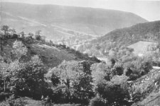
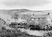
Glen Auldyn
[From Mate's Isle of Man Illustrated, 1902]
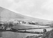
FROM Ramsey the great south high-road that leads to Castletown runs westwards on the flats, touching the most advanced abutments of the hills, till at Kirk Michael, nine miles out, it takes a sharp bend southwards. Three magnificent glens twist out from the mountains en route, viz. : Glen Auldyn, Sulby Glen, and Ballaugh Glen. In the neighbourhood of Glen Auldyn are many places of beauty and interest, to visit which Ramsey should be a halting place for some days. The roads are all perfect for cycling. Carriage hire is cheap. The Manx Northern Railway from its terminus at Ramsey, runs to St. John's (fifteen miles), where it forms a junction with the Isle of Man Railway, Douglas and Peel branch The Manx Northern has stations for all the places of interest along its route. Soon after leaving the Ramsey station it crosses to the north bank of the river and follows it to Sulby, where they part company.
Glen Auldyn
THERE are three roads to Glen Auldyn. The first is towards Albert Tower Hill, past the foot of Elfin Glen, a very sweet wooded ravine west of the tower, and along the hill west of Clybane, a fine old Manx place, perfectly characteristic, half mansion, half farmhouse, shaded with giant elms.
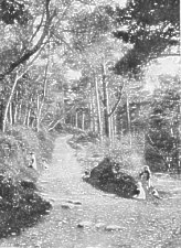
Elfin Glen
The second route is by the Lezayre Road, past Milntown, and to the left up the flats by Glen Auldyn River. The third route is a riverside path from Ramsey Bridge through Greenland, also entering Glen Auldyn just beyond Milntown. Skyhill is a beautifully wooded and very steep abutment upon the plain, of a ridge of heights standing out from the mountains. Glen Auldyn is the gorge winding between-a gorge with the wild and weird fascination of surprise and mystery. The first mile is seductive with all kinds of picturesque grace road and river gliding along flats, with nestling cottages and straggling fringes of trees and truant woodland, the afternoon sun scarce clear above the ridge of Skyhill.
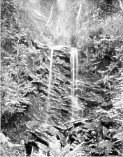
Spoot Voar, Glen Auldyn
On the left, in a side ravine, is the Alt or Cascade, in Manx, the Spooyt Vooar (great spout), which gives its name to Altdale corrupted into Altyn. Its Norse name was Braid Foss. The main glen narrows, assumes a wilder aspect, with increasing upward gradient, the summit of Snaefell topping the folding vista southwards. At a lonely spot three miles out the glen forks-a steep climb to the left leading to the Snaefell Road, and over the col to the right the hill path to Sulby.
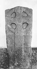
THE ridge of Skyhill is the traditional battle field of Skogar Fell, where, circa 1075, Godred Crovan defeated Sitric and won the Island. There is a ruined chapel and burying ground on the ridge, dating from, probably, the days before the arrival of the Scandinavians to Man. With the exception of the view from North Barule, that from Skyhill is the finest in this part of the Island. it looks down on the roofs of Milntown, just parted from the base of the hill by the road and river of Glen Auldyn, debouching into the Lezayre Road and the Sulby River.
Milntown is the seat of the Christians, the most remarkable and the most Manx of all Manx families, undoubtedly of Scandinavian origin. The original name was McCristen, changed to Christian about three centuries ago. John McCristen was Deemster in 1408. Three John McCristens were, in succession, Deemsters, during the reigns of Henry VII. and Henry VIII. The last of these (Rent Roll, 1513) was the largest proprietor on the Island, holding three mills, a brewery, the fishery of Sulby River, the estate of Altadale, and other lands in Lezayre and Maughold. From this family sprang the Christians of Ballure, of Lewaigue, and of Ballakilley in Maughold. The most famous member of the family and the most famous of all Manxmen was William Christian (Iliam Dhone), third son of John Christian, Deemster (1605-1656), his eldest brother John, also Deemster. William Christian inherited Ronaldsway, near Castletown, by the marriage of his aunt to Deemster Sansbury. He became Receiver-General of the Island (1647), and Commandant of the native Militia. In 1651, he seized the Island and treated direct with the Parliament, on finding that the Countess of Derby, contrary to her pledge, was making terms for herself only : whereas the Manx people claimed the preservation of constitution, jaws, and lands. He became Governor of the Island ; was deposed by Lord Fairfax ; and after the Restoration of the Stuarts in England, and the Stanleys in Man, was tried for treason. His condemnation was achieved by the expulsion of the principal Members of the Keys, and the incarceration of the foremost of them. He refused to plead, and treated the trial as a judicial murder. He was shot at Hango Hill, on the shore of the Castletown Bay. The judgment was reversed by Charles II. in council ; and the sequestrated estates restored to his son, as also the estates of his supporters.
The mansion of Milntown, beautifully situated among woods and shrubberies, is modern, re-built by Deemster Christian (1830). Some of the doors are of oak preserved from the old house, which is traditionally said to have been made from a ship of the Spanish Armada wrecked on this coast. A tradition also states that the Manx rumpy or tailless cat is derived from a progenitor brought ashore from this ship and domiciled at Milntown. The fittings of the library are of Manx bog oak from Lough Malar.
Between Milntown and the hills, a fine golfing course has been laid out on the undulating flats, unequalled in the beauty of their superb surroundings.
FROM Ramsey by train or road Milntown and Skyhill on the left, Lezayre Church (re-built 1835) is passed half-a-mile further on. The steepled tower and ivied church is very picturesque. At the foot of wooded hills the mansion of Ballakillingan on the flats was the seat of the Curpheys. Ewan Curphey, of Ballakillingan, was associated with Iliam Dhone (1651) ; and his estate sequestrated (1662) but afterwards restored. It is still held by representatives of this family. There are also some charming residences at intervals further on. The name Lezayre in the Rent Roll Lez Ayre, is the name of the Sheading. The parish Holy Trinity of Lez Ayre has taken its name from the Sheading, as at the extreme south of the Island the parish of Holy Trinity of Rushen is called Rushen. The Sheading of Ayre comprises the parishes of Lezayre, Bride and Andreas. The Lezayre Road is richly timbered and of surpassing beauty ; the hills and ravines being clothed with plantations all the way to Sulby.
The Claddagh, Sulby
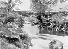
The district as far as Sulby belonged to Rushen Abbey, traces of their ownership surviving in the Grangeh (Grange) and Ballamanagh (Monk's Farm). Sulby, originally the name of two estates (or treens), is now applied to the whole district. Beyond the fourth milestone the road turns towards the plain, crosses the river at Sulby Bridge and again turns west through a hamlet called Sulby Village. At the former turn the hills withdraw into the upland glen of Narradale, which, with many charming recesses, descends from the ridge overlooking Glen Auldyn, and opens on Sulby River with Cronk Sumark on its right, and on its left the Claddagh. An old high-road goes straight on by the base of Cronk Sumark, fords Narradale Brook, crosses the Claddagh, fords the Sulby River, passes through the hamlet of Old Sulby, and skirts the abutment of Gob-e-Volleh on the Curraghs of Ballaugh, joining the modern road at that point. The railway lies farther on but curves alongside the road at Gob-e-Volleh. There is a station near Sulby Bridge and half-a-mile farther another for Sulby Glen.
Sulby Bridge
Cronk Sumark (Shamrock Hill), a bold isolated dome of grassy hill with crags near the summit, is crowned with a prehistoric earth fort. The Claddagh (water-side flat) is a green waste never turned by the plough, partly overgrown with a delightful wilderness of gorse, in early summer a blaze of gold. It is a common famous in old times as the scene of Sulby Fair. But this institution in Man is practically obsolete. The hills after the recess of Narradale advance on the Claddagh very bold and craggy, with irregular ash woods straggling along their skirts over the river. The heights of Gob-e-Volleh advance half a mile further to the plain, beyond the entrance to Sulby Glen. Between Sulby Bridge and Gob-e-Volleh are the station on a cross-road from Jurby up into the Glen ; the church, a pretty modern building, a chapel-of-ease to Lezayre ; and the mill, which is on the side facing the mountains, is one of the most picturesque subjects for the artist to be found on the Island. With Sulby is associated the origin of " Mylecharaine," the Manx national air and song.
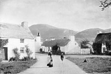
Sulby Old Village
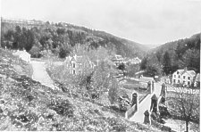
FROM the station it is a quarter-of-a-mile to Old Sulby hamlet, and half-a-mile to the river bank at the mouth of the Glen. Old Sulby has a woollen mill for Manx homespun, and at the mouth of the Glen a disused starch mill--once an active industry. This point is bewilderingly beautiful. A ravine comes down from the right from Carran mountain. Here is Kilculberagh, or St. Cuthbert's Church, the site only traceable. The ascent of Carran Mountain gives a succession of magnificent mountain views, especially along Sulby Glen to Snaefell. The first reach of the Glen is eastwards. The Glen sides are inaccessible steeps of grass and gorse broken by projecting crags. At the bend the Glen turns south. On the left, beyond the river and a little nook of mountain crofts, is a high cascade, called the Cluggit, in the elbow of the Glen. It comes from a ledge several hundred feet above the tiny fields and clumps of ash trees embowering the homesteads to which a footbridge and ford invite an hour's exploration of its hinterland.
Tholt-e-Will Bridge
Up the Glen is a long vista of two miles. Road and river are side by side the road rising and dipping, and rising again. The river tumbling, rushing, and resting with wild water-music all the way. The interest centres at Tholt-e-Will, about four miles from the station. The left side of the Glen, as we ascend, is wooded: and a ravine comes down from that side, with a Chalet Hotel among the trees. Just beyond it is the bridge: and the road crosses and ascends out of the Glen up the side of Snaefell. This road passes the Bungalow and goes on to Douglas. Tholt-e-Will is at the northern foot of Snaefell. The waterfall is in a wild gorge behind the hotel. The whole spot is exceedingly lovely, with a charming sense of loneliness, which is its peculiar note.
Further up the valley, southwards, is Druidale, and beyond is the Forester's Lodge dating from the days of the Lords of Man. There is an ancient burial ground at Druidale ; and plantations enrich the slopes, whila the river ravine has natural woods of ash and mountain ash, over the glissades and throbbing pools. On the right or north side is the Sherragh Vane (White Foal), an immense boulder perched on the hillside. A zig-zag path leads from Tholt-e-Will past the Sherragh Vane and across the moors to Ballaugh Glen. The little farm which takes its name from the white boulder is the scene of the Rev. T. E. Brown's " Kitty of the Sherragh Vane." This path gives, en route, magnificent views of the mountains, from North Barule to Pen-y-Phot, and the whole circle of heights dominating a vast moorland in the heart of the Island. The summit westwards from Snaefell is Pen-y-Phot, "the mountain of turf." The great peat moss on its northern slope, not yet exhausted, formerly supplied the fuel most commonly used over the whole north of the Island.
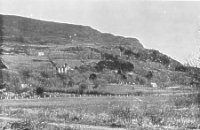
FROM Sulby Glen Station, road and line skirt the base of Gob-e-Volleh, in view of its quarry famous for immense flats of blue clay slate used for foot-bridges, and for prehistoric cists, thousands of years ago The hills towards Ballaugh have little timber, but are very rich in colour and of fine outline and form. The village is at cross-roads formed by the intersection of the main road by a transverse road from Old Ballaugh, passing up Ballaugh Glen. The village is not ancient, but is pretty and pleasant. It had once a hat factory, and a brewery. Carmodale or Ballaugh Glen derives its character from the fine mountain Slieu shoo, at the head, connected with the Kirk Michael Hills, which form the west side of the glen. Road and river run for some considerable distance side by side, and are surrounded on every side by scattered timber, picturesque farmsteads, cottages, and enclosures fenced with little lines of wood and solid sod fences. A branch on the left is Glen Shoggil or Ravensdale, up which climbs the road to Druidale and the Forester's Lodge.
Ballaugh Old Church
The main glen has no exit over the hills, and an afternoon spent in exploring its quiet yet fascinating charms will live long in the memory of the tourist who is the happy possessor of an eye to quiet rural beauty. An old horse-path from Ballaugh ascends on the ridge west of the glen, and follows the line of the Kirk Michael Hills for some miles, afterwards striking across the mountains to Douglas.
FROM Ballaugh Village to Michael Village is three miles. Bishopscourt is midway--between road and railway line. A glen from Slieu Curn (Hill of the Cairn) the most northern of the three summits of the Michael Hills, divides the demesne equally ; and the Court is beside the embouchure of this glen. At this point the sandy dunes interrupted in continuity at Old Ballaugh, shut out the seaward view again, and enclose a shallow basin of fields and meadows. This hollow is called Orrysdale ; anciently an extensive mere; but the Bishopscourt rivulet now winds through the meadows and finds outlets to the sea at Glen Trunk, a narrow twisting gap cut through the dunes. Bishopscourt, surrounded by fine timber, is on the landward side of Orrysdale, and Orrysdale House, also hidden in woods, is on the seaward side. Bishopscourt was anciently Bala Curi. The oldest part is a tower with walls twelve feet thick, dating from apparently the 13th century. From this tower, in the basement of which is the Bishop's library, the chapel built as a Procathedral by Bishop Powys (1855) runs eastward; the Court, the work of successive Bishops, notably Wilson and Powys, runs westward. The old tower had a moat, fed by the stream from the glen--part of which is still in good preservation. Part of the Court was destroyed by a disastrous fire (1893) ; but was restored and much beautified by Bishop Straton. In the restoration a large runic cross was discovered serving as a lintel over the door from the hall to the dining room. A stained glass window was also found built up into one side of the hall. This window, restored with great care, is still a valuable accession to the beauty of the hall. Bishop Rowley Hill filled up the gaps in a complete set of portraits of Bishops from early in the 17th century. An old yew stands on the north side of the chapel, conjecturally about 500 years old. Some of the trees planted by Bishop Wilson also remain. The Chapel contains the four stalls of the Canons of the Cathedral Chapter, reconstituted by Bishop Stratton ; and attached to the Court, on the West, is the Bishop Wilson's Theological School, where clergy are trained for the Manx Church. The Bishop is patron of four and the Crown of thirteen of the ancient parishes. The Bishop is also patron of four Canonries, of four town vicarages, and of several chaplaincies. The Diocese was founded by Olaf I., of Man, in 1134 ; prior to which time there existed the Celtic Church, organized from Irish and Columban Missions at the earliest dating from the 5th and 6th centuries. The first Bishop associated with Bishopscourt was probably Symon, Abbot of Iona, Bishop (1229-47). The most famous occupants of the See have been Symon, Mark (127[1] -1313), Barrow (1668-71), Wilson (1697-1755) and Hildesley (1755-72.) Barrow was the originator of the foundation that subsequently has developed into King William's College ; and Hildesley procured the translation of the Manx Bible. Sodor and Man, formerly one Diocese, were separated in 1380 ; but the Bishops of Man have continued to retain the ancient title.
THE glory of this locality is its beautiful hills, Shen Curn, Slieu Farrane and Sartal, rounded grassy fells composing into a superb and exquisitely tender whole. Between Bishopscourt and Michael the road cuts through a tumulus in which the runic crosses were found, now preserved at Michael Church. The mansion, with central tower at the foot of the hills, is the White House. Its story is romantic. Joseph Mylchreest, a native of Peel, after many wanderings in the colonies, found fortune in South Africa ; and became a "Diamond King." On the verandah of his house in Kimberley, a conversation with Ewan Christian, of Milntown , turned the current of his thoughts homewards, and he returned with a fortune of " six figures," to purchase an estate and settle down as a Manx squire. He had just accomplished his dream, having become a magistrate and a Member of the Keys for his native town ; when he died in the prime of life on the threshold of his hopes. There is a memorial window in Kirk Michael Church to his memory. It is understood that Pete Quilliam's South African episode in the " Manxman " was based on the story of Joseph Mylchreest.
Manx Cross, Kirk Michael
The church (1833) is cruciform with a square tower. The runic crosses preserved here are very fine, and the inscriptions valuable as bearing on their history. In the churchyard -Are the graves of Bishops Wilson, Hildesley, Criggan, Phillips, and Mason. Bishop H ildesley's grave is at the foot of Wilson's, whom in life he made his model, and at whose feet he desired to be buried. The village is pretty and has a windmill, now rare in a Manx landscape, but formerly common, In Kirk Michael the most notable industry is oak carving, chiefly of church furniture. At the upper end of the village is a Courthouse the last survival of several country Court-houses. Till within recent years the Northern Deemster and Vicar-General held Courts at Kirk Michael. Travelling facilities have had the effect of transferring all Courts to the principal towns.
Glen Willyn, Kirk Michael
AT the court-house the road forks, the main road to Castletown, bending south to cross the height, the right hand following the coast to Peel. This road dips into Glen Wyllin and crosses by an embankment. The glen seawards, has smooth sward, gorse, and a mill on the shore, and is a point for excursions. Above the bridge is a charming hamlet screened from all winds, with the buildings of a disused brewery and a pretty mill, near which Fullers Earth is dug. Higher up are woods over-hanging a canon cut by the stream in glacials clays of great geological interest. The water is tinted blue like the glacier streams of Switzerland. On the, heights west of the glen, by an old high-road once the route to Douglas, was discovered an immense find of flint weapons now in Ramsey Museum. Towards Peel, by the coast, is Glen More, with the Spoot Vane (or white spout), a fine waterfall broken into foam over a crag of conglomerate rock. The banks of glacial clay below the fall are curiously like rock, and are geologically of much interest. A ruined mill near the sea in this glen points to the decay of local industry. At Glen Cam the view towards Peel Castle is very fine, as from every point of this coast. The basalt on the coast, and the red sandstone formation resting on the underlying slate, give this district a special interest to the geologist. Over the Lhergy Dhoo, three miles short of Peel, are the remains of a fine circle of Cyclopean quartz boulders, the " Giant's fingers." A large number of cairns, burial grounds, and some recorded finds of weapons, constitute the antiquarian interest. The Manx Northern Railway from Kirk Michael follows the coast to Lhergy Dhoo, and then strikes to the left to St. John's. Leaving Michael by the south road with Glen Wyllin on the right, a stream from Slieu Farrane crosses the road, coming through a glen with elm woods, that joins Glen Wyllin at its most charming point. Over the stream the road skirts Cronk Urleigh, a miniature hill on the skirts of Slieu Farrane. Reneurling, Cronk Urleigh, or Eagle Hill may derive its name from .pie eagle crest of the Stanleys. It was the Mote Hill, probably the Sheading Hill of Michael. Soon after the arrival of the Stanleys, a Tynwald was held here in 1420, the scene of a rising against Captain Walton, the Lieut.-Governor, who with his men were driven to Michael Church to defend themselves-first in the churchyard and subsequently in the church. Each of the six Sheadings seems to have had a Tynwald of its own till the Glen Faba Tynwald, conveniently near to Peel Castle and central to the Island became the sole Tynwald.
Glen Helen
AN ascent through a sterile but well cultivated upland leads to Cronk-y-Voddy. The road crosses a plateau and descends to Glen Helen, with magnificent prospects of the southern mountains. This region is described in the " Captain of the Parish." The church is modern (1850), a chapel of-ease to St. German's, the parish church of Peel and German. The average size of a Manx parish is about fourteen square miles, the shape irregular, and the parish churches seldom central, out-lying districts are often six or seven miles from the parish church. Hence, in part, the explanation of the many small Methodist Chapels. Two parallel ridges of foot hills lie between the mountains and the coast westward. Between these hills and the mountains is Glen Helen. The name is modern, replacing the older Rhenass ( Rhen-eas=district of the waterfall). The upper reach is Glen Dhoo, the second Little London, the third Glen Helen, the lowest reach opening on the Vale of St. John's is Glen Moar, in all five miles. The upper valley has grassy slopes and mountain farms. At Rhenass the valley closes in and assumes a grander character. The river drops from the higher to the low glen over a succession of falls in a gorge of water-worn blue slate, overhung with pines and all the wealth of ferns and woodland greenery. Nass or Nyhass is in Manx a waterfall. The tributary stream of Glen Blabere from the slopes of Colden. skirting Beary Mountain, a beautiful heather- hill, a westward spur of Greeba, joins the river at the foot of the last and finest of the falls. The glen below is densely wooded down to the hotel standing by the high-road, descending from Cronk-y-Voddy by a side ravine at that point. For the next two miles road and river run together through Glen Moar. In some respects this glen surpasses Sulby, especially in the beauty of its windings, the feeling of solitude, and in all the details of rural tenderness. At the embouchure of the glen, the darkbrow of Slieu Whallian rises in front ; the road crosses to the left bank ; and river and a branch road bend to the right towards Peel.
Greeba Castle, the Home of Hall Caine
BALLA CRAINE is the point where the high-road from Ramsey to Castletown north and south, and the high-road from Douglas to Peel east and west, intersect. Looking towards Douglas the profile of Greeba Crags, overhanging Greeba Castle the residence of Mr. Hall Caine, nestled in the gap of the central range, bounds the view.
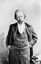
Mr Hall Caine
The most curious structural feature of the Island is the Gap of Greeba The mountain range, continuous for twenty-five miles, from North Barule to Port Erin, is cut through down to 140 feet above sea-level. On the divide is a pretty mere below the gardens of Greeba Tower and Greeba Castle, from which streams flow eastward to Douglas, and westward to Peel, the railway line skirting the south and the high-road the north banks. The Castletown road ascends through Foxdale, over the east shoulder of South Barule. The summit is a blunted pyra mid, purple in its heather,, envelope: and on its slopes are the chimneys and engine-houses of the lead mines in which the district is very rich. The air line to the summit is about four miles. Slieu Whallian, a lofty spur cf South Barule, very bold in its abutment on St. John's Valley, and and with frowning brows of slaty crags stands on the right of this view.
St John's Church and Tynwald Hill
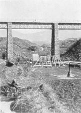
HALF - A - MILE towards Peel is St. John's on a perfectly level plateau in the open valley, central to an amphitheatre of hills, with vistas of glens radiating between them. The Douglas and Peel branch of the Isle of Man Railway is below the plateau southwards. The high-road crosses it over the Fairfield, which occupies the south half; on the north half is the enclosure of Tynwald. The precincts are girt by a rampart of stone and earth in the figure of a dumbbell--the church occupying the eastern, the Tynwald Hill the western lobe. A gravelled path cuts the sward from church to hill. The hill is a circular mound with three terraces, and a flat summit, to which grassy steps lead up on its eastern side. A flagstaff in the centre floats a flag and supports a canopy on Tynwald Days, when new acts are promulgated and become law. The great annual day is July 5th, when also a fair is held on the field outside the precincts. The ceremony was revived by the Stanley Lords of Man early in the 15th century ; but though it had probably been in abeyance for a century-and-a-half, it went back to Scandinavian times. The ceremony consists of a religious service in the church, a procession to the hill, the promulgation, the return ceremony, and a Tynwald Court in the church. The precincts, the church, and the hill, are on these occasions strewn with green rushes, a custom said to date from Godred Crovan days, but doubtless of even greater antiquity. Certain lands were held on the tenure of the holders providing rushes for the Court. Rents were commuted into money payments at least as early as the 15th century. But in the Abbey Lands and the lands of Bishop's Barony chief rents are still paid partly in kind. As the promulgation ceremony is unique, the following are its details : A detachment of troops stationed on the Island, the Isle of Man Volunteers, and the Royal Naval Reserve Brigade form a guard of honour. The Governor and the Speaker of the Keys wear Windsor Court uniform; the Bishop his Episcopal robes; the Archdeacon and Clergy their surplices ; the judges their gowns and wigs ; all others ordinary dress, viz. : the Keys, High Bailiffs of Towns, Captains of Parishes, and Sheading Coroners. The Governor is preceded by a sword of state-that formerly carried being a two-handed sword with Three Legs of Man on the hilt and pommel, dating from 13th century. The Church of St. John's is modern (1855), cruciform with tower and steeple, in decorated style and of yellow tinted local granite. One runic cross only survives from this locality it is preserved in the south porch of the church. Reginald and Olaf meet here in battle (1228), Reginald being defeated and slain ; and (1239) the Manx defeated the Islesmen after disagreeing in a Tynwald Court.
Peel, from Michael Brows
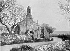
IT is two miles to Peel, the highroad direct, the railway and river making a bend to the left. The Manx Northern line from St. John's to Ramsey runs a little way towards Peel and then bends northward. Slieu Whallian on the left and all the land across the river are in the parish of Patrick. This district is richly wooded, comparing with the more famous district between Ramsey and Sulby. Kirk Patrick Church is visible half-a mile beyond the river. Right ahead a long, narrow and lofty hill, detached from the main mountains, skirts the west coast from the ravine of Glen Meay southwards to its northern termination at Peel. The square tower on the summit, 500 feet above the sea, is the burial place of the Corrin family, proprietors of the hill and the lands at its base. Hill and estate are called Knockaloe (Hill-of-Olaf), from Olaf I. (1114-1154) or Olaf 11. (1226-1236), who both resided at Peel Castle, on a rocky islet, separated by a narrow channel from the north end of the hill.
St Patrick's Isle, Peel
The Sheading of Glen Faba (vad-byr=ford town) comprises German and Patrick parishes, separated by the stream from Greeba to Peel, with which unite Rhenass and Foxdale rivers - the latter loaded with blue mud brought from the "wash" at Foxdale mines. These rivers were formerly famous for salmon and the Rhenass river is still an excellent trout stream. The river skirts Knockaloe Hill, the line on its right bank.
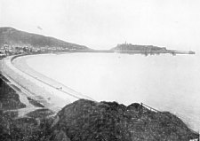 Peel Bay and Castle |
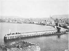 Peel Town and Harbour |
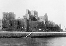 Peel Castle from Pier |
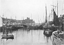 Peel Castle and Harbour |
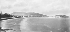
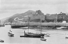
The station is at the head of the harbour, the estuary of the river, between a causeway Joining the hill to the castle islet, and a red sandstone quay and pier on the side of the town. The towers and gables of the castle and roofless cathedral rise against the sky seawards, beyond a perspective of coasters and fishing luggers and a most irregular red sandstone town sloping up from the harbour, its line cut by the tower of the old disused church at the Market-place. The bay opens northwards, St. Patrick's Isle being north west of the town. The shore is a shallow crescent of fine pink sand and shingle, ending at the rose-red sandstone cliffs of Creg Malin, half-a-mile from the pier head. The water is wonderfully clear, and is renowned for its intense and lovely blue. Beyond Creg Malin the coast is precipitous, the beds dipping seawards, hollowed into caverns and enclosing beautiful strands. Farther on are the scarped sandy brows of Kirk Michael as far as Orrysdale Head, beyond which the coast of Jurby appears as a long promontory, with the church on the seaward -extremity. For the marine painter this is the richest colour subject on the Island. In the fishing season the bay and harbour, crowded with herring boats, are all animation and picturesque beauty. The Peel fishermen are the beau ideal of a sea-faring race.
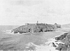
THE approach is by the west side of the harbour and along the causeway, or by the ferry from the pier head to the Castle steps. The'pier stands on a tidal spit, called the Wart (Norse Vad, a wading - or landing - place). The passage is but fifty yards. The slaty rocks of St. Patrick's Isle rise from fifty to one hundred feet to the Castle wall, which surrounds an area of four acres-a footpath, and here and there a strip of sward outside. This immense embattled curtain, about thirty feet high, dates from the time of Thomas II., Earl of Derby (1504-22), and probably replaced an earth rampart. The Isle is highest on the S. fronting the hill, lowest at the N.E. where a projecting sally port, tower and circular redoubt overlook the modern break-water protecting the bay. Bastions and small towers occur round the ramparts ; on the N. side is the Moar's Tower, where Capt. Christian was imprisoned. The Moar was the Lord's Receiver. In 1510 there were two, of Peel and Rushen respectively, each in charge of three sheadings. A N.W. tower with lower chamber and narrow tortuous postern exit, is Fenella Tower, associated with Scott's " Peveril of the Peak." The circuit wall is of grey and green Silurian slate quarried from the cliffs, but the more ancient parts of the Castle, the Cathedral, St. Patrick's Church, and Round Tower are of red sandstone from Creg Malin. The Castle proper on the S.E., overlooking town and harbour, of Scottish work, does not appear older than 13th century, and was probably built or enlarged after 1275, by Bishop Mark. To the basement guard-room belongs the story of the Mauthe Dhoo, or :Black Dog, a jeu d'espirit of Waldron, who wrote a hyperbolical account of the Island (1726). In the centre of the Isle is a pyramid mound, the earth being taken from around it to form a deep fosse-its purpose and age obscure. St. Patrick's Church, roofless, with bell gable fallen by its western door, its east end a less ancient extension, with no north window, and with string courses of herringbone work round the interior, dates from about the 9th or loth century. Till 1715 it was the parish church of Kirk Patrick. Opposite its west door on the highest point of the Isle is an Irish Round Tower, its lower part only being ancient (the upper part re-built. in cylindrical form, with a crown resting on projecting corbels)probably of 10th century.
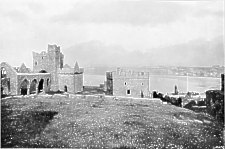
Town and Bay of Peel, from Castle
The glory of St. Patrick's Isle is the Cathedral Church of St. German. The choir (transition with Normanesque characteristics) was built about 1195, in the time of Reginald I., whose sister Aufrica, wife of John de Courcy, Lord of Down, was a patroness of the Cistercian order, and founded two Abbeys in Down. This chancel is manifestly the work of the same builders. The lower walls, of very early work, probably belonged to a still older church. Bishop Symon (1229-47) built the tower, transcepts, and nave, the character of the suggesting Iona as the model, Symon having been Abbot of Iona. The buildings north of the Cathedral, called the Bishop's Palace, in arrangement and design closely resembling those at lona, also point to Symon as their founder. His grave is on the Isle, but its site unknown.
St German's Cathedral and Peel Harbour
The chief incidents in the history of Peel Castle are the landing of Magnus Barefoot, 1098, ; its use as a state place of exile notably of Thomas, Earl of Warwick (1397-9) ; its seizure by the native Militia in the Rising of 1651 ; and its use as an ecclesiastical prison, The Earl and Countess of Derby occasionally resided here.
THE town centres in the Market - place on a terrace some 50 feet above the harbour. Beside it is the disused church of St. Peter. The modern church of St. German, built by Bishop Rowley Hill (1885), on the upper skirts of the town, has a fine spire, and internally is a beautiful church with good stained-glass windows. The Sea Promenade, half-a-mile in length, sweeps from the harbour to Creg Malin. Peel has excellent hotels and boarding houses, and has summer steam communication daily with Belfast. Its fishing industry is prosecuted during the spring months on the S.W. Coast of Ireland (mackerel), and during the summer months on the E. Coast of Scotland and in home waters (herrings) but is less profitable than formerly. It has three important net factories ; two shipyards for fishing vessels and coasters ; and a rope-walk. That it is an up-to-date watering place may be inferred from the fact that " mixed bathing," is in vogue, on the shore of Traie-fogogue (literally, Strand under the Cliffs). Mr. Hall Caine resided on the Promenade while completing "The Manxman." Scenes of the "Captain of the Parish" are also laid in Peel, under the name of Inchport. The coast route southwards is by car, cycle, or on foot. A mile out is Kirk Patrick Church. On the left, the traditional battle-field of Santwat (1098) between the Manx of the north and south, in which Ottar and Mac Marras, the chiefs, were slain. The south gained the victory, aided by the women rushing to the field.
|
|
||
|
|
||
|
|
||
|
Any comments, errors or omissions gratefully received
The Editor |
||