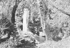
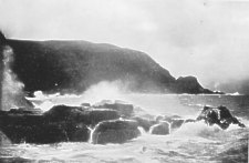
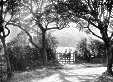
Dhoon Fall
[From Mate's Isle of Man Illustrated, 1902]
THE line from Laxey is down the valley to the Northern Headland of Laxey Bay. Several fine views are seen from this section, notably the vista of Glen Roy with its densely-wooded recesses and Cairn Gerjol beyond, the semi-circle of mountains around Lonan, and the coast towards Douglas. The second reach along the coast is a steady ascent through the Abbey Land farms. A spur of Creg Agneash, separates Lonan from Maughold, its seaward end being an indention called Bulgham Bay. The ancient high-road is farther inland over the ridge ; the modern road quarried through the scarped end of the spur, 400 feet above sea-level, where slaty cliffs descend into the water, being of a piece with the famous Corniche Road. To carry the electric line around the point, a still deeper cutting was made in the scarp of the hill. This was conceded to the Highway Board, and the former high-road on the edge of the cliff utilized for the railway.
ONCE: round the turn, a view of finer proportions than any in Onchan or Lonan, suddenly opens on the right. A purple mountain, a fan of green fields narrowing downwards between two ravines, that broaden and deepen into a richly-wooded gorge that sinks out of sight down to the sea; beyond the gorge a dome of rock hill, sparsely clad with gorse and heather, its sea-cliffs of slate beds set on edge and glittering with mica ; and behind the whole North Barule in majestic grandeur looking down on Maughold at its feet. The horizon line of the mountains is by an air line some three miles away.
Dhoon Fall
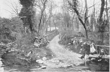
The cascades in the gorge and the surf on the shore 400 feet below, are heard in alternations distinguishable and confused together. A little way down are disused lead mines. The footpath descends by irregular zigzags following the gliding and plunging torrent. Timber grows all the way down. One moment we look seawards over the summits of tall pines, and the next moment our heads pass level with their roots. The principal fall makes two leaps of sixty and seventy feet respectively; and there are many lesser cascades. Ferns and moss flourish in the coolness and moistness of shade and spray. The grass grows long and soft, and trails over the banks ; and long festoons of ivy hang from tree and rock over dark circling pools, and glissades of invisible dark water.
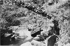
The Smugglers' Arch, Dhoon Beach
The appearance of the Dhoon shore suggests the pictured scenery of the Sandwich Islands. The romantic possibilities of the smuggling days are everywhere about this little shore, its hollowed cliffs, and arduous paths through the woods to the upland farms that look down upon it.
The Corony
FROM the Dhoon, road and line continue together, passing the granite quarries (paving sets and road mineral), the head of Glen Mona (described later on). and the Dhoon Church, a Chapel-of-Ease to the Parish Church of Maughold,- when they part company, the road to the left, the line to the right. The high-road crosses the Ballaglass River at the Corony, with picturesque bridge, cottages, smithy and mill. In a cottage beyond the bridge was born the poet Kennish, whose poems The Melliah " (Harvest Homej, and the " Oiel Verry " (Christmas Eve), descriptive of country life in Maughold, have gained him a permanent niche in the little temple of Manx writers. He served in the Royal Navy, retired to the Island, and afterwards emigrated to America, where: he died (1864). "The upper valley, westwards from the Corony, ascends to the base of Clagh Ouyre (1800), and is a magnificent solitude. Half-way up are North Laxey Lead Mines, connected with Laxey by workings underneath the mountains. Glen Barule is a tributary ravine, with ash, mountain ash, and other natural woods. The upper streams are full of excellent trout, very little fished. On the northern slope, is an ancient church and burial ground, with a cross dating from Scandinavian days.
From the Corony to Ramsey the road skirts the base of North Barule, and descending round foothills that form its seaward pediment fronting on Ramsey Bay by a long descent called. Lewaigue Hill, meets the line again near Ballure, a mile short of Ramsey. The farmhouse of Lewaigue, buried in trees below the road, was the seat of a remark able family, the Christians of Lewaigue, a branch of the Christians of Milntown. The arms of Ewan Christian of Lewaigue, the friend of Bishop Wilson and associated with him in the Commission that framed the Manx Act of Settlement (1702) figure in one of the blazoned windows of the House of Keys Chamber in Douglas. In Lewaigue House, Mr. Hall Caine resided for some time, while writing "The Manxman."
Electric Tramway Viaduct, Ballaglass Glen
BELOW the Corony the river flows through Ballaglass Glen. The Electric Railway crosses the river half-a-mile below the Corony Bridge, and has a station on the edge of the woods. The beauties of Ballaglass Glen are embraced within a short half-mile of forest-like woods. The peculiar character of the river course is caused by the bedding of the slate strata. Platforms and ledges project over waterworn pools and gorges excavated by the torrent. Vast detached blocks lie about tenderly broidered with moss, and laced with luxuriant fern.
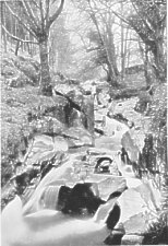
Ballaglass Falls
The falls are a series of cascades of no great height, but infinitely varied through thewholeravine: Disused lead mines on the outer edge of the woods are so over-run with vegetation as to seem rather a part of the work of Nature than of man. Every Manx river has its legend of the water-sprite.In Ballaglass is the Phynodderee Gorge, believed to be the haunt of this being.
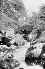
Phynodderee Gorge, Ballaglass
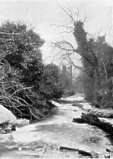
On the Rhenab Hill, westwards from Ballaglass, is a stone circle known as Castle Gorry (viz. : Orry), the treen of land between Ballaglass and Glen Mona being Baliagorry, or the Manor of Orry. At the foot of Ballaglass proper the old high-road, dating from the days of the saddle and the pack, crosses the river by a most picturesque ford. From this point to the sea, river and valley, are called the Cornaa, a locality so retired, so beautiful, and with so much character as to be considered the loveliest spot on the Island. Here originated the Manx song, Berry Dhone,-" oanrey brawe bwee (fair skirts of yellow)," of which one saw " a yellow flash in the glen."
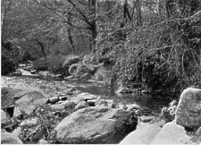
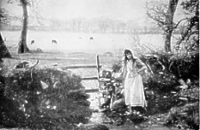
Cornaa River.
The Ford at Cornaa Mill
THE Mill at Cornaa is of great antiquity. In the Rent Roll (1513) it appears as the property of John McCristen, of Milntown, who was Northern Deemster and the wealthiest man on the Island. In a cottage, west of the ford by the old road, the old Manx hand-loom is still in use. Following this road one can visit Castle Gorry, :and the head of Glen Mona. But Glen Mona is best approached from its lower end near Cornaa Harbour. The valley, seawards from Cornaa Mill to Cornaa Harbour, is well wooded, and has pretty little meadow enclosures along the river. This section is good trout water (especially for sea trout). Cornaa Harbour formerly had a fleet of fishing boats in the days when the Maughold farmers followed the herring fishery in boats of their own. Now there is not a trace of this lost industry. The electric telegraph, skirting the base of the Barony Hill and the woods of Glen Mona, joins the submarine cable which is laid from Cornaa Harbour to St. Bees, in Cumberland.
River Scene in Glen Mona
This Barony Hill rises between the Dhoon and the Cornaa, but further inland it separates the Dhoon and Glen Mona. The hill formerly called Ryncurlyn was granted to the Priory of St. Bees ; and has still the ruins of the Barony Chapel on its summit. Glen Mona is a tributary of the Cornaa. The river pools still bear the old designation : Linga--a pool. The Phynodderee Gorge of Ballaglass has its counterpart in the Linga-Glashtin, or pool of the glashtin (water-horse), in Glen Mona. This glen has the charm of all Manx glens-the charm of tenderness.
In Glen Mona
From the tiny ghyll of the tributary rivulet, to the great glens of Sulby, Rhenass, and Glen Rushen, there is an exquisite, a passionate tenderness in them all. But Glen Mona has yet other graces. Verdure is abundant, almost tropical. The festoons of ivy, single trailing sprays or broad valances over the rocks, have a richness unequalled elsewhere. Its beauties are all hidden. One discovers them, as if no human eye had ever looked on their loveliness before.
Glen Mona Fall
BELOW Ballaglass the line goes seawards over the end of a spur on the N.E. side of Cornaa Harbour. The views are superb. On the landward side is Ruillick-ny-Quakeryn (burying place of Quakers). The Friends visited Man in the 17th century, and made converts of members of the principal families of the district, especially the Callows of Balla-Callow. William Callow was imprisoned (1665) in St. German's crypt for religious,contumacy, and banished from the Island. Prince Rupert interceded with the Earl of Derby for his return, but in vain. He married a Quaker heiress, a Miss Warland, of Oxfordshire. In a subsequent generation, through failure of direct issue, the Wardell. Callow estate passed into Chancery. The Callow family were unable to establish the connection, and the property remains in Chancery still. Maughold Church, to the right, comes in view at the turn from the coast through the Vale of Lewaigue to Ramsey. Here the prospect opens : Ramsey Bay, the Point of Ayre, and the coast of Scotland come into view. On the way to Maughold Church the road passes Port Mooar, described in " The Manxman.''
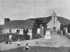
St Maughold Church
MAUGHOLD HEAD rises beyond a fertile depression that extends From Port Mooar to Ramsey Bay. The Port Mooar coast is irregular and shelving, the Ramsey Bay side a wall of rock rising sheer from the deep water. The church is within the angle of coast heights, at the head of a slope that faces S.W., and over-topped by the dome of the Head. The churchyard, of five acres, is the largest ancient burying ground in the British Islands. It is, in fact, a primitive mission station of the Celtic Church, probably Columbian. An immense earthwork rampart can still be traced within the present wall, and several small churches stood within the precincts. The present church was enlarged from a smaller one of great antiquity. In 1860 it was taken down to within six feet of the ground, and restored with symmetrical windows, the old windows being destroyed. Fortunately both gables escaped the mutilation. The west door has jambs of Normanesque work, but the arch is gone, and a runic cross rests on them as a lintel. The west gable was re-built, most probably by the Cistercians of Rushen Abbey. The east window cannot be older than the 16th century. It is broad and low, with triple-lighted Perpendicular work roughly adjusted to the aperture, brought from elsewhere, probably St. Bees, on its dissolution. On either side of this are curious lychnoscope windows. The church is typical, a simple oblong with characteristic bell gable. The runic crosses of Maughold are the finest in the Island, dating from 11th, 12th, and 13th centuries, and grouped for preservation about the churchyard gate. Bishop Roolwer's Cross, 11th century, south of the church door, is especially interesting.
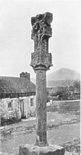
St Maughold Cross
A fine cross of totally different character, probably 14th century, stands outside the gate on the left (see view). Nothing is known of its history. A sun dial, on the open area, is inscribed " Edward Christian, 1666." The Christians of Ballakilley, a little way nearer Ramsey, were an important family. Capt. Ed. Christian, who served in the West Indies as Captain in the Navy of James I., was Governor of the Isle of Man (1628-40). He was imprisoned by James VII., Earl of Derby, in Peel Castle (1643-51) for favouring the Parliament cause. At the restoration (1660) he was again imprisoned ; died in Peel Castle (1661), and was buried at Maughold. This person was the prototype of Christian in Scott's " Peveril of the Peak." The sun dial bears the name of his son. In the " Rushen Chronicle " the church is called St. Machutus (1154). The name Maughold, surviving as the name of the parish, is derived from another church in the precincts.
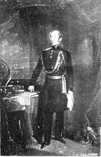
Major General Sir Mark Cubbon
Maughold Vicarage is the birthplace of General Sir Mark Cubbon, K.C.L., Governor of the Indian Province of Mysore. He was the son of the Rev. Thomas Cubbon, Vicar of Maughold (1770-1802),and Vicar-General of the Diocese. Sir Mark was Governor of Mysore (1834-61). He distinguished himself by the preservation of perfect tranquility in Mysore during the Mutiny. He died at Suez on the voyage home, and was buried in Maughold (1861). There is a fine equestrian statue of Sir Mark, by Baron Maroschotti, in the City of Mysore. The Grammar School of Ramsey and the Cubbon Almshouses are of his foundation.
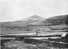
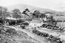
Vale of Maughold and North Barule Mountain.
N. E. of the church, over the ridge, and on the edge of the cliffs of Ramsey Bay, is St. Maughold's Well. It was anciently resorted to for its curative " charm," especially on the first Sunday of August. The district is rich in iron and copper, and the mines were formerly very valuable. The mine shafts and levels tapped the drainage of the district, and the well is almost dry.
Maughold Head
Maughold Head is twenty-eight miles from St. Bees Head in Cumberland. The Cumberland coast and mountains are visible by day ; and the furnaces of Workington by night. An estate in Maughold, still called the Staff Land, was formerly held on the tenure of keeping in safe custody the staff of an early bishop. All trace of the staff has long disappeared. The parish records do not go back more than two centuries.
Port-e-Vullen
FROM Maughold to Rarrsey, the descent of two miles ends at Port-e-Vullin, or the Port of the Mill ; over a level, another half-mile on, is Port Lewaigue,-these places have pretty little shores with a few cottages and some good modern villas. Inland is Crowville, the residence of Captain Hugh Crowe, a famous fighting slave captain, who is buried at Maughold. He was a native of Ramsey, born 1765 ; and made a reputation in his day by beating off French and Spanish men-of-war, who attacked him on his " middle-passage " runs. On one occasion he fought a running engagement of nine hours with the Dart and Wolverine, English warships, whom he mistook for Frenchmen. Seaward, between Port-e-Vullin and Port Lewaigue, on a low promontory, is the site of Fort Loyal, that formerly protected Ramsey Bay.
THE two foot-hills that form the pediment of North Barule abut steeply on Ramsey Bay, facing eastwards. The south front is bare, the north clad in timber, and between them is the wooded gorge of Ballure Glen. High up in its recesses are the waterworks of Ramsey : and on the brow of the north hill is Albert Tower, commemorating a visit of the Queen and Prince Consort in 1847. The Queen remained on her yacht in the bay, where she received the Bishop (Lord Auckland) and others who came on board. The Lieut.-Governor (Hon. Chas. Hope), who resided at Castletown, was unable to arrive before the Royal Squadron weighed anchor. The lane up Ballure Glen leads up to the tower ; also the lane through the woods on the Ramsey side: From Albert Tower the view over Ramsey and the north is very fine ; but inferior to the superb view from Skyhill, visible to the west. The new mountain road from Douglas to Ramsey, by way of Snaefell, comes down by Albert Tower. A fine example of an old Manx high-road is seen a few yards from Ballure Bridge on the Maughold side. Admirers of Hall Caine's " Manxman " are on classic ground at Ballure. The curious thatched cottage near the water trough is commonly accepted as the home of Black Tom and Pete; the ruined mill in the ravine as Caesar Cregeen's mill; beyond the bridge on the Ramsey side Old Ballure House, formerly the seat of the Christians of Ballure, as the home of Aunty Nan and Phillip Christian. In the garden is a magnificent fuchsia tree, said to be the largest in the world. It is solarge as to hide half the house from view. The fuchsia grows to perfection on the Island owing to the mildness of the winters. Ballure Glen is a place of delightful seclusion and tender beauty. The upper reservoir is a long sinuous lake, man's work scarcely suggested in the broad embankment across the Glen. North Barule is reflected in its depths, and it is completely shut in by heights, except where a glimpse of the sea is seen through the wooded ravine eastwards. Between Ballure Bridge and Ramsey, among the fields on the left of road and line, under the woods of Albert Tower Hill is Ballure Church, attached to the vicarage of St. Paul's, Ramsey. The site is ancient. Nearly two centuries ago Bishop Wilson re-built it ; but the present church is recent. The Sunday afternoon service in this little church among the fields is a favourite resort of people visiting Ramsey in summer, in fact it may almost be called the Old Kirk Braddan of Ramsey.
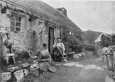
Pete's Cottage.
THE best ascent of North Barule is by the new mountain road past Albert Tower; or for choice by Ballure Glen, and through the fields. For mountain views this summit is by far the most panoramic on the Island. The coast of Scotland, from the Mull of Galloway to the Solway, and the entire coast of Cumberland can be distinctly traced in clear weather. The intervening sea is a mere strait. The hill of Albert Tower overlooks Ramsey,and North Barule overlooks both. A blunted lancet on a razor-edged ridge at the extreme N.E. end of the central mountain range, it dominates the whole of the northern end of the Island. While the mountain axis lies S.W., a mass of lower hills with a westerly tree stand out from the mountains and abut steeply on the northern plain. This plain, some forty square miles in area, is fertile and richly cultivated, having on its eastern side Ramsey Bay, and the Point of Ayre at its northern extremity. It has no elevation exceeding 100 feet above sea-level ; with the exception of the Bride Hills ( 300 feet) in the direction of the Point of Ayre. North Barule looks down on its parquet work of farms, fields and meadows, the Bride Hills being, from this altitude, merged in the uniform level.
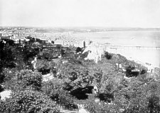
Ramsey, from Pete's Cottage
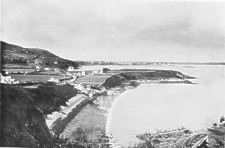
Ramsey Bay is a semi-circle; the diameter an air line of ten miles from the Point of Ayre to Maughold Head. The Sulby River, flowing eastward along the base of the lower hills, enters the sea through Ramsey Harbour, the town being mainly on its right bank on the shore of the bay. To Maughold Head the coast is steep ; the part beyond Port-e-Vullin sheer walls of dark slate.
A superb curve of sandy shore extends to the Point of Ayre, backed by scarped brows of sand, gravel and clay, richly coloured with tints of yellow, pink and red, deepening into purple in the evening shadows.
 Claughbane Road, Ramsey |
 Claughbane, Ramsey |
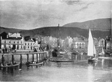
The Harbour, Ramsey.
WHETHER originally Ramsa, Ramsoe, or Ramsway, water island or landing place of Hramn or Hrafn, it is unquestionably a Norse name. Godred Crovan, founder of the last dynasty of Manx Kings, won the Island from Sitric in the battle of Scogar Fell or Sky Hill (circa 1075) near Ramsey. Olaf I. of Man, son of Godred Crovan,was killed by his nephew Reginald at a parley held here (1154). Somerled of Argyle, with fifty-three ships, defeated Godred II. of Man, at Ramsey (1164). In 165 i, after the defeat of Charles II. at Worcester, a Parliament expedition of forty ships, under Captain Duckenfield, landed at Ramsey, after signing conditions favourable to the Islanders, and received the surrender of the Island from William Christian (Iliam Dhone), commandant of the native militia, who had raised the country, and seized the garrisons in order to be in a position to treat with the Parliament. In 1690, William III. of Orange, on his expedition to Ireland, where he ruined the cause of James II. at the Boyne, passed across Ramsey Bay. One of his vessels took the ground off the bay at what has since been called King William's Bank. In 1760, Captain Elliot with three frigates fought the French adventurer Thurot with three ships off Maughold Head. The action lasted an hour- and-a-half. Elliott was completely victorious, captured all three ships of the enemy, and brought them into Ramsey Bay. The body of Thurot, who was shot in the action, was thrown over-board by his own men ; and the bowsprit of his flagship, the " Belle Isle," shot off and drifted ashore, was long preserved as a flagstaff at Bishopscourt. Ramsey had a fort but only the identity of the sight remains near the shore in the older part of the town. The arrangement of Ramsey is picturesquely irregular, along its fine tidal harbour. Two squares, the Market Place and the Court-house Square connected by a short street, constitute the focus of the whole. The Market Place is between the Harbour, and the north facade of St. Paul's Church, the other two sides being occupied by hotels and shops, the fronts and frontages of which are picturesquely irregular. Schooners, smacks, ketches, and small steamers indicate an active trade. There is, in fact, a large export trade in agricultural produce ; and the Foxdale Mining Company receive timber and coals and ship their ore here. In the middle of the square is the Fish Market. Across the Harbour are visible the red sea brows and green dunes of Bride, the curving vista of shore with its lace-like flouncing of surf around the sapphire of the bay-one of the finest seascapes of the Island. Between the Market Place and the Promenade is the oldest part of the town, short narrow streets and sharp turns. In this part is the Roman Catholic Church, just off the Promenade, a simple exterior, but a good interior. Two interesting old streets, many of the houses of the last century, run parallel to the Promenade frorn the Market Place to the Old Cross, where they join the Maughold Road. The cross which once stood here has disappeared. Waterloo Road, dating from 1815, is a third parallel on the landward side, and is in the main street on entering Ramsey from Maughold. The Electric Railway Line is carried behind Waterloo Road to its terminus on the site of a most picturesque old house, now demolished, the original of Pete Quilliam's Ramsey home in Hall Caine's "Manxman."
The large Wesleyan Chapel is near the station ; and opposite a cross street to the Court House Square. The square is west of the Market Place, the Court House standing on a grassy area with trees, and around it high iron railings. Modern brick chambers, the legal quarter of Ramsey, are on one side, and in this block is Mr. P. M. C. Kermode's Museum. This is the private collection of an enthusiastic antiquary and accomplished ornithologist, the recognised authority on Manx runic crosses. Students interested in the Manx crosses will find it worthwhile to address themselves to Mr. Kermode, whose magnum opus in the Museum is a complete set of casts of the crosses. On the harbour side of the Square begins Parliament Street. The Isle of Man Bank, the Post Office, some of the best hotels and places of business front the Square on its several sides. Parliament Street runs west, parallel to the harbour, and is pre-eminently the chief business street of the town. Ramsey having long been a favourite place of residence for people of means, the shops are not inferior to those of Douglas. There are two newspaper offices, the Courier and the News; many good posting establishments ; and every description of business is well represented. The Primitive Methodist Chapel is a prominent building on the south side, in Gothic style ; and the street ends at the Town Commissioners' Office, a handsome Elizabethan edifice. Lezayre Road, the continuation of the thoroughfare, is the high-road that traverses the Island from north to south, its terminus being Castletown, the distance twenty-five miles. The turn to the right at the Town Offices leads to the Railway Station ; and over the bridge at the head of the harbour to North Ramsey and the high-road to Bride, Andreas and Jurby.
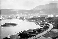
Mooragh Lake and Park, Ramsey
THE suburb north of the harbour is somewhat withdrawn from the bay, there being between the Mooragh. The Mooragh was formerly a waste of sand and gravel, sparsely overgrown with grass, bent and gorse ; but transformed at immense cost into an important attraction to the town as a watering place. The old embouchure of the Sulby River, along the north shore brows, has been made a tidal lake, surrounded by a public park. The seaward side of the Mooragh has a promenade, with blocks of boarding - houses fronting the bay. A swing bridge over the harbour, erected at a cost of 650,000, connects the Mooragh Promenade with the town. In North Ramsey, on the the brows overlooking the Mooragh, the Rev. T. E. Brown, the Poet of Manxland, resided from 1892 to 1897, his attachment to Ramsey being partly for the charm, freedom and health of the place, partly on account of family associations. His favourite walk was along the North Shore brows as far as the Bride Hills. Flint implements have been found on the Mooragh brows; these traces of primitive man being common on the Island.
RAMSEY has three piers, one on either side of the harbour, extending to low water, both having port lights ; the other quarter- of-a-mile southwards, towards Ballure, and extending nearly half-a-mile into the bay, where steamers can land at all states of the tide. This pier, costing £45,000, opened in 1887, was in honour of the jubilee, called the Queen's Pier. South of the Queen's Pier, as far as Ballure, is the Ladies' Bathing Shore. Between the Oueen's Pier and the harbour is the Children's Shore. Beyond the harbour northwards, abreast of the Mooragh and beyond it, the North Shore provides the most admirable bathing ground on the Island : all that is needed being the usual provision of a light bathing tent. The bay is famous for its sea-fishing, and is a safe yachting water, being free from treacherous tideways. The Mooragh Lake is also popular for boating, being free from any kind of risk. Model yacht sailing is much in vogue on this lake. Ramsey Bay is the most frequented anchorage in the Irish Sea. The ground is good; there is ample scope for any number of vessels to anchor and swing without crowding, and it is sheltered from all westerly winds. This circumstance has given Ramsey a foremost place in the list of life-boat stations on the British coasts. The Ramsey life-boats and their achievements rank in the first roll of the annals of the National Life-boat Institution. The leading spirit of the Ramsey Association for over a quarter of a century past was its president, the Rev. George Paton, Vicar of St. Paul's, who turned out as regularly as the coxswain and crew, working at the launching of the boat like an old salt, and speeding her with God's blessing on her errand of mercy into the fury and the roar of the stormy sea. Needless to say, his influence with seaman and landsman was a feature of " Ramsey town '. Ramsey town ' shining, by the sea."
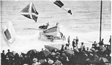
Launch of the Ramsey Lifeboat
The Life-boat House is beautifully appointed, and fronts the Promenade. It is the gift of Mr. and Mrs. Norbury, of Port Lewaigue. The Church of St. Paul's is certainly without an element of external grace, though its little square tower by the Market Place, overlooked by North Barule, has a suggestion of the Square of Innsbruck in the Tyrol. Its interior, apart from architectural beauty, is a well appointed Church with good stained glass in its windows.
St. Olave's Church, in North Ramsey, notwithstanding its dedication to St. Olave, is a modern foundation. Ramsey has also a Presbyterian Kirk in Waterloo Road ; Wesleyan and Primitive Methodist Chapels; and Methodist New Connexion Chapel. The Grammar School and Almshouses in Waterloo Road, were founded by Sir Mark Cubbon, Knt., but the School had a more ancient foundation, with a small endowment, originating in the 17th century. There is in North Ramsey a Home for Waifs and Strays attached to Dr. Stephenson's London Home.
|
|
||
|
|
||
|
|
||
|
Any comments, errors or omissions gratefully received
The Editor |
||