[From Manks Antiquities, 1914]
As regards the British Isles generally relics of the Bronze Age are associated with human remains of a different type from those of the earlier period. In particular they are brachveephalie, or broad-headed, instead of dolichocepllalic, or long-headed. Their average height seems to have been somewhat greater. The soft and regular outline of the logg-headed race is replaced by more harsh and rugged features, with massive lower jaw, prominent cheek-bones, and brow- ridges more strongly marked. Their dwellings " probably were of much the same character as those of the Swiss Lake population, except that for the most part they were placed upon the dry land, and not on platforms above the water. Their clothing was sometimes of skin, sometimes of woollen cloth, and probably of linen also as they were acquainted with the arts of spinning and weaving. Of domesticated animals they possessed the dog, ox, sheep, goat, pig, and finally the horse. They hunted the red deer, the roe, the wild boar, the hare, and possibly some other animals. For the chase and for warfare their arrows were tipped with flint and not with bronze ; and some other stone instruments, such as scrapers, remained in use until the end of the period." 1
It is natural to suppose that these men of the Bronze Age on first establishing themselves spread over England and some parts of Wales and Scotland before they came to the Isle of Man, and, when they did arrive in the Island, they were probably in the later division of the Bronze Age, that period of which bronze swords, palstaves, and socketed celts, such as have been met with here (fig. 20), are characteristic implements.
Fig. 20.-Bronze Socketed Axe, from the Kimmeragh, Kirk Bride.2
The dwellings in the Isle of Man appear to have been similar to those of the Neolithic folk-possibly larger and better built. It may well be therefore that some of the groups of huts to which we have referred as originating in Neolithic, continued in use in Bronze times. As we have stated there is some evidence that those on the Mull Hill were occupied even much later.
We have traces also of crannoges, or pile-dwellings, artificial islands formed of stones, tree-trunks, and smaller stuff piled up, in a lake or morass, and kept in position by stakes so as to make a platform upon which huts could be built in a secure position, surrounded by water. Elsewhere these lake-dwellings are mostly of Neolithic or Bronze Age, though some have remained in use into historic times. Until the Manks examples have been more carefully examined it is impossible to say to which precise period they belong.
On Ballacarnane Mooar, near the Spooyt-vane, Michael, just above the railway, is an unhewn stone pillar or Menhir set upright on a little crag facing the sea (fig. 21). At its foot are some cup-hollows cut in the out-cropping rock, about 4 in. in diameter and 2441 in. deep ; and, a little below, on the face of the crag, is a larger, shallow, basin-like hollow.
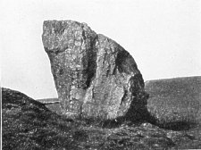
PIG. 21. The Carnane Standing Stone and cup-marked rock at Michael.
From a photograph by Mr. J. R. Quayle.
Within an earthwork enclosure, on the rocky peninsula of Burrow Ned (Burrow yn Edd) near the Calf Sound, are three basin-like hollows and some smaller cup-masks cut in the face of the out-cropping rocks. Large stones at the Braddan Camp, and at Oatlands Circle, Ballaglonney and Grainvick Bay, Santon, are marked with cup-like hollows. All such marks, with the concentric rings and wavy lines with which they are sometimes associated, are generally regarded as belonging to the Bronze Age. In some instances such cup-marks appear to have been intended to hold offerings to the dead.3
Comparatively few loose articles of bronze have been recorded, and of these most have been lost. So far as is known, those found consist of colts plain and socketed, palstaves, swords, dagger and spear heads, and sickles (see fig. 22, showing a group of characteristic forms now in the Museum at Castle Rushen, and fig. 20 showing two socketed bronze colts).
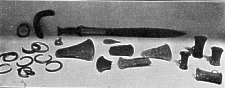
Fig. 22.-Bronze weapons from the Isle of Man.
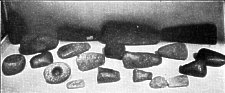
Many of the polished stone implements, all of which appear to be of foreign material, must have been introduced during this period (see fig. 23, which shows some of those now collected at Castle R,ushen ; fib. 24, showing a perforated stone hammer ; and fig. 25 some of the larger polished stone axe-heads that have been found-all probably of this same period).
Fig. 23.-Manks polished stone implements of Bronze Age.
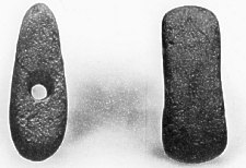
Fig. 24. Perforated Stone Hammer of Bronze Age, from Foxdale, 5¼ in. long.
A considerable amount of pottery belonging to this period has come to light, generally, however, in fragmentary condition.
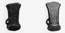
This consists of cinerary urns and food vessels, not turned on a wheel, frequently ornamented and generally of superior manufacture to that of Neolithic times. Types of various patterns found are shown in fig. 26. Several smaller urns, much more hiffhly decorated, have been met with and probably belong to this time. The beautiful little vessel shown in fig. 27 with a five-angled star inscribed on the base was found at Cronk Aust, near Ramsey, and contained burnt bones and earth. Another somewhat similar in type was discovered, empty, in a stone cist near Laxey.
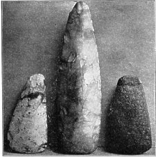
Fig. 25. Polished Stone Axe-heads from Bride and Jurby ; largest 8¾ in. long.
With the Bronze civilisation, the practice of inhumation in cists formed of heavy slabs of stone gave way to that of cremation, although both were probably for some time carried on simultaneously. Our few implements have been generally found scattered on or near the surface, seldom in association with other remains, but our knowledge of the pottery is derived solely from the burial mounds of this period, such as those above referred to, which appear to have continued in use for a long time, as well as others of later date. The small round tumuli or cronks, still so numerous, for the most part appear from their contents to belong to this age.
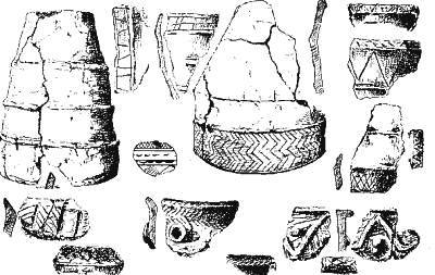
Fig. 26.-Bronze Age pottery, from the Isle of Man.
Reduced from sketches by P.M.C.K. (not all drawn to the same scale).
We shall now describe one or two typical examples of these. A mound at Ballaseyr, Andreas, examined in 1884, when it was being cut through in. order to form a new fence, was found to measure 4 to 5 ft. high by about 24 ft. diameter at the base; it was composed entirely of heavy red sand. Near the centre, placed mouth downwards on the original surface, was an urn (one of those shown on fig. 26) half full of calcined bones, measuring 16½ in. high by 15½ in. in diameter across the mouth. The material is a stiff clay with the usual mixture of crushed stones, in this case slate, quartz, granite and trap, from the size of a mustard seed to that of a French bean. The surface is smooth, the colour reddish-brown. An ornamental border 4 in. deep consists of two lines round the urn, between which four rows of diagonal lines form a sort of herring-bone pattern. Within, the bevelled lip is ornamented by two lines, between which are short diagonal strokes. All the lines are formed as if by a bluntly-pointed stick, or possibly by pressing a twisted cord on the plastic clay.
Another mound at the White House, Michael, examined in 1888, when it was removed for building purposes, stood about 7 ft. high, and when perfect the diameter was about 40 ft. It consisted of a bed of red sand, 2½ ft. at its greatest thickness, upon which was heaped a cairn of broken quartz, 2½ ft. deep at the centre. Above was another 12 in. of red sand, and some 6 in. of surface soil. It was in this upper sand, resting directly on the quartz, that the urns were met with, together with some charcoal and flint flakes. Six urns, all broken by down-growing roots of gorse, bramble and grass, measuring from 8 to 12 in. high, were found, one of which was ornamented by lines of short strokes without definite design ; one also had a sort of chevron pattern inside the lip. These contained incinerated bones and earth. The largest was 28 in. in diameter. Another, 9½ in. high, was 9 in. in diameter. When subsequently the rest of the mound was removed, no more pottery was met with, nor was there any trace of a cist.
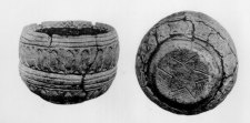
Fig 27 Two views of a small urn from Cronk Aust
Another mound at Cronk Aust, Lezayre, now levelled,* measured 30 ft. in diameter and 6 ft. high, and was composed of soft red sand and gravel. Near the centre was the small urn referred to above (fig. 27), filled with calcined bones, and placed mouth upwards, just above the original level of the soil, upon a thin layer of dark burnt earth and charcoal. It measured 4½ in. high by 6½ in. in greatest diameter, and was of unusual shape, decorated with simple but effective design. In this mound, about 6 ft. from the last urn, was a larger one (shown on fig. 26), 12 in. high, with diameter across the mouth 9½ in., and across the bottom 3¼ in. This also was filled with calcined bones, and set, mouth downwards, about 4 ft. below the surface of the mound. A flint, possibly a rude arrow-head, 1¼ in. by ¾ in., was found with some ashes about eight yards away, and about six feet below what appeared to have been the original surface.
Many of the mounds in the north and west of the Island have been found to contain from one to twelve, and even fourteen urns, measuring from 12 to 14 in. high (some were even larger), and sometimes highly ornamented. They are generally placed mouth downwards, sometimes on a flat stone, and are filled with burnt bones. Unfortunately, only a few broken fragments have in most cases been preserved (fig. 26).
Very rarely have bronze articles been met with in these burial mounds. Only two instances of bone implements are recorded. Of the very few silver ornaments found in the Island some may possibly belong to this period, but in the absence of any direct evidence it would not be safe to speak with certainty. Beads have occasionally been found apparently in connection with Bronze Age burials, but have been lost again without any description or proper record being made. A solitary article of gold is fortunately preserved in the British Museum. This is a thin disc, 2 in. in diameter, ornamented by three concentric circles of small punched holes. From comparison with finds in Ireland, Scotland, and on the Continent, it seems likely to have been a votive offering connected with the worship of the sun.
It is, in the present stage of our knowledge, difficult to say whether there was a distinct Age of Iron in the Isle of Man, and, if there were, when it merged into the Historic Period. No undoubted Iron Age pottery has been recorded, nor have the typical burial grounds been brought to light, and nothing has been made known showing the peculiar decorative art of that Age. A few of the pre-Christian burials may, however, belong to this division. Although cremation was still carried on in Britain, a change began in the burials, and the dead were frequently interred laid at full length in a stone chamber, or shallow pit, along with articles used in the daily life.
In a field at Bishopscourt a mound previously reduced almost to the level of the field was examined in 1888 and found to contain a cist about 5 ft. long by 2 ft. 2 in. wide, formed by two side-stones set on edge; in it were remains of burial by inhumation, the body having been laid on its side, head northwards, the knees apparently doubled up. A large stone pillar, 8 ft. 6 in. long by 16 in. wide, found lying across the N. end, might originally have been set upright at the head of the grave. Some charcoal was met with outside the S.E. corner of the cist. Another close by had a capstone 3 ft. 8 in. long by 2 ft. 8 in. It was filled with loose sand, but fragments of a skull were met with; also a small urn (full of sand) the shape of a flower-pot, 3¾ in. high by 4½ in. diameter at the mouth, and 17/8 in. at the bottom. Both cists contained broken red quartz, and rounded white pebbles. These burials may perhaps be of late Bronze Age or of a transition period between Bronze and Iron.
A tumulus at Lhergy-rhenny, on the S.W. shoulder of Snaefell, levelled in 1883 in order to obtain material for fencing, may have belonged to this same period. The mound was between 4 and 5 ft. high, and over 16 ft. diameter. On its N.W. side was a small cist of flat stones set on edge, with some minute fragments of pottery on a layer of ashes. Near the centre was a chamber built of stones carefully laid flat, with sods between them, covered by a capstone a few inches below the top of the mound. The chamber measured 5 ft. long by 2½ ft. wide, and 2½ ft. deep, but nothing was found in it. Just below, and at a different angle, was a similar wall of another chamber on a layer of wood ashes, resting on flat stones, which appeared to have been laid on the original surface. Here and there in the mound were pockets of broken red quartz and small fragments of baked pottery.
The Rev. S. N. Harrison, in 1884, opened a mound on the Barony, Maughold, in the centre of which was a long grave, lying E. and W., lined on the sides with flags, and having a flag-stone at the W. end, but with the E. built up. To the north was a second stone-lined grave ; above were traces of ashes.
In 1909, Mr. Harrison opened a barrow on Ballaterson, Maughold, differing in structure from any previously recorded. It was on the slope of a hill and, when excavated, revealed a circle about 24 ft. inner diameter, with an opening to the north-west. Several stones on edge outside may have been the remains of the outer boundary of the ring of rubble. The entrance was formed by a slab on edge at either side, from 3 to 4 ft. long, and about 2 ft. 6 in. high, followed for about 3 ft. by rough walling continued to the inner stones of the circle. These were flat and set on end, about 18 in. high, but the south-east part of the circle for about one-third of its circumference was formed by the edge of the rock which had been scarped to a depth of 12 in. The floor was partly of rock, partly rubble; ashes of charcoal and bone were found adhering to it, whilst the fire had reddened the rock on the north-east side. Other layers of burnt bone and charcoal were met with, some beneath thin slabs of stone. Quartz pebbles were scattered throughout the soil, but the only implements found were stone pestles, 6 in. to 8 in. long, rounded at both ends, together with a smoothly-worn fine-grained piece of granite, 2¾ in. diameter by 7/8in. thick, pierced by a hole about an inch in diameter, counter-sunk.4
Some of the mounds still existing may belong to a much later date, that, namely, of the Scandinavian settlers, who arrived as pagans about the end of the 9th century, and became Christian in the 11th. Though this Scandinavian nature of some of the burial mounds is certainly likely, we are not aware of any evidence as yet recorded on which to determine the question.
Tynwald Hill itself may possibly have been in its origin a burial mound of peculiar sanctity, afterwards converted into a place of assembly. Though there is no record to that effect there can be little doubt that it was a hill of assembly and of inauguration before the Scandinavian occupation, but the present name at all events dates from that period. It resembles the " Moot-places," of which remains are still found in Iceland and Norway, and a few in England and Scotland. In these there was always a plain; a hillock or mound; a court due east of the hill, and a temple. 5 Tynwald Hill in its present form is an artificial mound, consisting of four circular platforms, the first having a circumference at the bottom of 256 ft., and at the top of 240 ft. ; the second platform has a circumference at the bottom of 162 ft. ; the third of 102 ft., and the fourth of 60 ft. It is situated at St. John's, 2½ miles from Peel, and is the scene of the formal assemblies held once a year on July 5th (Midsummer Day, old style), when the new laws are read to the people in the open air.
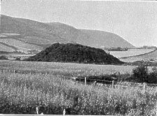
Fig. 28.-Distant view of the Cronk-Howe-Mooar, from the South-East.
In the " Chronicon Manniae," under the year 1249, it is recorded that Reginald, Olaf's son, King of Man, was slain on May 30th by the Knight Ivar, " in a meadow near the Church of the Holy Trinity at Rushen."6 It is also stated that his body was taken for burial to Rushen Abbey-a very natural and probable event, as Reginald was a Christian King, and Rushen Abbey was the chief ecclesiastical establish- ment in the Island and the burial place of several previous Kings of Man.
But local tradition in the south of the Island has it that Reginald was buried in his armour in a great tumulus-like mound near Port Erin. This is the mound known to English visitors as " the Fairy Hill " (fig. 28). It is marked as " Cronk Mooar " on the Ordnance Maps, but most of the natives living around call it " Cronk-y-mur," which is nearer to what there is reason to believe is the ancient Manks name meaning Hill of the Fort. The second word, which is the Manks article " of the," would seem to have become confused by a Norse-speaking people with their own word " Howe," after which the third word " Mur," a fort, was taken to represent the Manks adjective " mooar," big. And in this corrupted form the name " Cronk- Howe-Mooar " has come down to us from the period of the Norse occupation of Man. Cronk and Howe being the Celtic and Norse respectively for " hill," the name has suggested that the successive early invaders had each called the mound " hill " in their own tongue and the later Manks, adopting both these, have added the final term, making the whole the " large-hill-hill " or, according to another interpretation, the " hill-hill-in-the-marsh." The surrounding meadows are still marshy, and were, no doubt, more so in earlier times.
The great mound lying thus on the low ground behind Port Erin and in a line between Fleshwick and Port St. Mary liays-and about one mile from each-is a conspicuous object Prom all directions. The suddenness with which it rises from the level field (fig. 29) and its regularity of shape, with circular I base and conical form, suggest that the whole mound is artificial, and this, along with or apart from the tradition of Reginald's burial has caused many archaeologists visiting the place to regard it as being probably a tumulus, and to compare it with the celebrated Maes-Howe in the Orkneys. For example, Mr. Arthur Moore, the late speaker of the House of Keys,author of the " History of the Isle of Man," refers to this similarity to Maes-Howe, and urges that the Cronk-Howe-Mooar should be investigated. The Geological Survey Memoir p 415) mentions it as a ridge of late-glacial gravel that liras been artificially shaped. The view has also been pretty generally held by visiting Antiquaries that the top of the mound, whether natural or artificial, had been subsequently used as a fort and shaped for that purpose; and, finally, an obvious trench or moat encircles the base.
There were thus various possibilities, and two or three rival theories, in connection with the mound, and for nearly thirty years we have been anxious to dig into the top and the base of the hill and set these doubts at rest. It has, however, been impossible, on account of the strong feeling locally against examining or interfering in any way with any prehistoric monuments, to obtain the necessary permission from both owner and tenant until in the winter.of 1912, when fortunately 6 we were enabled, partially at least, to carry out our intentions- with the following results :-
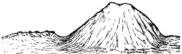
Fig. 29. Sketch of the Cronk-Howe-Mooar, from the Moat, at the North side.
The mound is approximately 30 ft. in height and about 420 ft. in circumference ; and the distance from the edge of the base to the centre is therefore about 70 ft. The shallow moat encircling the mound is on the average 20 ft. across. The irregular top of the hill measures about 40 ft. by 30 ft. (S.S.W. to N.N.E.), and has a depressed central area of 30 ft. by 25 ft., surrounded by raised edges, or earthen ramparts, 7 ft. or 8 ft. in height.
The trench that we cut into the outside of the hill from the base started at the S.S.W. point (which we chose because of the uniform steepness of the slope and the apparently undisturbed base), and led inwards towards the centre. About 2 yds. in we came upon a well-marked bed of sand 2 ft. from the floor and 6 in. in thickness. The rest of the section was ordinary brown earth, containing many fragments of stones- Manx slate and others, mostly angular. We then took a step upwards and continued the excavation on the top of this layer of sand for another couple of yards, when we came upon a well-marked layer of clay about 3 ft. from the floor crossing in fact the middle of our section. The rest of the section was as before. Both the sand and the clay thinned off and died away towards the outside of the hill, and seemed to be getting thicker as they ran inwards. We then raised our level again to the top of the clay and continued in for another 2 yds., and by this time we had got well into a bed of loose gravel, occupying the end of our tunnel about 18 in. from the floor. The stones in this gravel were rounded pebbles of various sizes up to an inch and a half in diameter, but many smaller, all obviously water-worn. We again raised the level of our excavation to a couple of feet above the layer of gravel, and continued in for another 3 yds., and during the greater part of this distance we had two well-marked bands of clay, which approached each other and thinned out, joined, and then disappeared towards the surface of the hill as seen on the sides of our trench, and seemed to be thickening and diverging still further as they ran inwards to the centre of the mound. We had now worked about 27 ft. horizontally inwards, and the floor of our trench had gone up about 6 ft. from the base of the hill; so we may conclude that we had sampled the structure of the hill for certainly more than one-third and probably nearly one-half of the distance horizontally to the centre, and from its base up to about half its height-and throughout, as far as we had seen, the sections showed a natural stratified surface of sand, gravel, clay, and layers of earth and stones (known to geologists as " Late-Glacial Flood Gravels "*), some slightly curved and lenticular, but all evidently bedded and having every appearance of having been naturally deposited by floods. There seemed no reason to believe that any other part of the major portion of the hill would show any different structure, so we next turned our attention to the artificial-looking earth- works on the summit, and first cut a trench 24 ft. long from east to west, and 6 ft. deep, through the raised edge or rampart on the western side. The section showed a well-marked core of grey clay under the surface soil and over the undisturbed bed of stony earth forming the top of the hill, and it seems probable that this wall of clay has been brought up from the moat, or from some other part of the surrounding marsh to steepen and stiffen the top edge of the hill. Another smaller trench through the opposite rampart, on the eastern side, showed much the same structure.
The depression in the centre of the top now engaged our attention. One small conical knob of stone was seen sticking up for a few inches from the grass (see fig. 30), and on digging down along its inner edge it was found, as we had expected, that this knob was the top of a large stone, about 4 ft. high, standing on end and forming part of a wall, which we then traced east and west for 18 ft. This southern wall, or rather revetment, for it was merely a stone facing on the inner side of the earthen ramparts, was rudely built of unshaped stones, some of which were long slabs of the local metamorphic rock, and others were water-worn boulders of glacial origin. The largest stones were placed upright and the smaller ones filled in between in rough courses. The photograph (fig. 30) gives such a distinct representation of this wall that any further description is unnecessary. The eastern wall, at right angles to this, measured 10 ft. 3 in. in length, and consisted of about seven larger stones along the base with about six courses of stones making a height of 3 to 4 ft. We then traced and exposed a similar wall on the north side and one on the west broken down in its central part-where there may possibly have been a gap, or step, forming an entrance. In short, we excavated a rectangular area of about 18 ft. by 10 ft., surrounded by the revetment wall and extending to about 4 ft. below the present surface of the ground-evidently the inside of a small fort or primitive defensive work on the summit of this strongly-placed mound in the marsh.
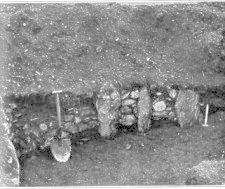
FiG. 30.-Southern Wall of small Fort on top of the Cronk-Howe-Mooar.
From the floor-level inside the wall it is impossible to see over the surrounding earthen ramparts, so the defence of the hill-top was no doubt carried on from the shelf of level ground outside and above the wall, with the rampart rising still for a few feet in front, and giving good protection. The walled area in the centre may have been roofed over with branches and turf as a shelter and store ; and it is not difficult to imagine that in the days of bows and arrows, javelins and swords, a party of about twenty or thirty fighting men might hold the little hill-fort indefinitely while raiding the surrounding country for their supplies. It is not large enough to be regarded as a place of refuge for the country side in time of invasion, but might well be a position seized and fortified by a small party of Norse raiders who were cut off, had lost their ship, or were otherwise prevented from returning north for the winter. It is of course possible that the fort may originally have been formed at a still earlier period, in Neolithic or Bronze times, and had then been re-occupied by the Norsemen, but we have no direct evidence of such earlier occupation.
The only object we found in the digging that could give any clue to the period and the people of the little fort was a small implement (fig. 31) or weapon of iron and wood which was found on the floor about 3 ft. below the present surface close to the base of the eastern wall.
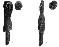
Fig. 31.-Iron and wood object from floor of Fort. A, broader face, andB, narrower edge; with both surfaces of detached boss. From photographs.
The entire length of the implement is 91 mm. (of which the iron part is 60 mm. and the wooden handle 31 mm.) and its greatest breadth 20 mm. The thickness of the iron part close to the handle is 15 mm., and its average thickness in the narrower blade-like part is 8 mm. The wooden handle varies in diameter from 8 to 9 mm. A "tang" of metal projects for something less than 20 mm. into the handle, and is about 5 mm. in diameter at its base, leaving only a thin shell of wood (a little over 1 mm. in thickness) at that point. The wood is stained with iron rust, and probably a good deal of its thick- ness has decayed away. The surface exposed is marked by very fine, closely-placed, and beautifully parallel lines giving it a silky appearance. It seems to be from a conifer, and is possibly yew.
The metal portion of the implement had, close to its free end, a small rounded boss, or separate scale-like piece of metal, which became detached in cleaning. This is of rudely circular form and measures 18 mm. in the longest diameter and 16 mm. in the shortest; possibly, as there are several well-marked angles in the periphery, it was originally octagonal in form. There are traces of a cavity between this detached'Piece and the rest of the metal.. and of one or possibly two rivets or pegs in the centre. On the outside of the scale- like detached piece there is, near one edge and therefore not over where the rivets were attached, a depressed pentagonal area about 4 mm. across. On the other side of the implement at this free end, just opposite where the detached scale has come off, there is a crack or fissure running for about 10 mm., and 1 mm. across at its widest, which may indicate the place of junction of a second boss.
At the opposite end of the iron, close to where the handle is attached, there is on one edge a well-marked flattened area, 15 mm. in greatest length and 11 mm. across at the widest, slightly depressed in the centre to the extent of about 1 mm. at most, which may indicate where another piece of metal has been attached. The rest of the surface is irregularly worn and rusty. Its general shape one might describe as cylindrical or slightly conical in its lower half next to the handle, and flattened or blade-like in the upper half. It might be taken for a broken head of a javelin or small spear, were it not for the detached boss, which had apparently been fastened to one side of the blade-like part.
The shape and appearance of the object and of the detached boss are well seen in fig. 31, reproduced from photographs of the wider and the narrower faces. The photographs were submitted to Prof. Oscar Montelius, of Stockholm, who writes that although the object is so corroded with rust that it is difficult to be certain, he thinks it is probably a broken iron arrow-head, and adds:-" We have such arrow-heads with a tang to be inserted in the wooden shaft ; they date from the Viking period."
We have made, then, in all, a complete excavation of the artificial works on the top of the " Cronk-y-Mur," a deep trench for 30 ft. up the south side of the hill, two sections east and west through the earthen ramparts, and two trial pits in the moat. The digging occupied the first week of 1912, and at the conclusion of the work, in accordance with the agreement made with the owner, the earth and stones were filled in again, and the turf restored. But there need be no doubts in future as to the natural origin and the human use of the mound, and we may give the following as a brief statement of what our investigation showed:-
1. The greater part of the hill is a natural mound of stratified sand and gravel with thin layers of grey clay. It is probably to be regarded as part of a small " esker " or kame of fluvio-glacial origin, piled up by the torrential floods which must have swept over the Isle of Man during the final melting of the confluent glaciers in late glacial or early post-glacial times.
2. We found no evidence of any burials or internal chambers in that part of the mound which we were able to examine in the limited opportunity afforded us.
3. The base of the mound may have been shaped to some extent by those who used it as a fort, and it has certainly been surrounded by a moat which on the east side separates the hill from an elongated ridge of sand and gravel, of which the mound was originally a partly-detached prolongation.
4. The top of the hill has also been shaped artificially and converted into a small fort,9 surrounded by earthen ramparts strengthened by a rudely-built stone revetment, enclosing a sunken quadrangular area about 18 ft. by 10 ft. This may originally have been roofed in as a shelter, and as it is too small to have served as a place of refuge for many people, the suggestion is made that it may have been a position with natural advantages seized and fortified by a small body of Norsemen wrecked, storm-stayed, or otherwise isolated on the Isle of Man at the time of the Viking raids in the ninth and tenth centuries.10
1 Evans, "Ancient Bronze Implements " (p. 487 of First Edition).
2 The blocks from which Figs. 20, 24, 25, 64, 65, 67, 68 are printed have been kindly lent to us from the Reports of the Trustees of the Manx Museum.
3 Yn Lioar Manninagh, Vol. I., p. 89. Manx Book, Vol. III., p. 91.
4 See Proc. I.O.M. Nat, Hist. and Ant. Sec. (new series), Vol. L, No. 8 (1913).
5, The Temple is here represented by the Church of St. John, and the Court is now held within it ; the Laws are proclaimed from the hill.
6 Chronic. regum Manniae et insularum-Munch's and Goss's translation (Manx Society, 1874), Vol. 1., p. 103 The next sentence reads:-" He was buried in the Chureh of St, Mary of Rushen,"
7 The mound is now (1914) incorporated in the Port Erin golf links, and the top has been levelled to form a " teeing " ground.
8 See Lamplugh, The Geology of the Isle of Man-Memoirs of the Geological Survey, 1903, pp. 371, 472.
9 In Allcroft's " Earthworks of England " (Macmillan, 1908) a number of small early Norman fortresses are described from different parts of England -all built on mounds and surrounded by a ditch. Mrs. Armitage in " The Early Norman Castles of the British Isles " (Murray, 1912) shows that it was the Norsemen or Normans who introduced little forts on moated hillocks into France, and later into England after the Conquest. (See also the description of the small moated " Castle-mound' at Tomen in Montgomeryshire, 30 ft. high, with a diameter at the top of 40 ft., and superficially very similar to our Port Erin fort, given in Report of Royal Commission on Ancient Monuments in Wales, 1911.
10 Dudo of St. Quentin speaks of the Vikings " fortifying themselves, after the manner of a castrum by heaping up earth-banks drawn round themselves." (Armitage loc. cit., p. 56).
|
|
||
|
|
|
|
|
|
||
|
Any comments, errors or omissions gratefully received
The Editor |
||