[From Manks Antiquities, 1914]
[note still under construction ]
The earliest traces of man met with in our district show him to have been then in the Neolithic stage of culture. Structural remains of the period are difficult to identify at first sight, and can only be determined with certainty by careful excavation and examination. They consist of habitations, camps or forts, and burial places. We have also examples of " Neolithic floors or platforms," that is to say, areas of the ancient surface where flint implements of many kinds have been actually manufactured. At the West Craig and the Lagagh in Andreas, at Cass-ny-havvin, near Ronaldsway, at Ballakaighan, German, and at Port St. Mary, have been found great accumulations of cores, chips, and worked flints of very primitive type.
On the brooghs overlooking Ramsey Mooragh, building operations about 1884 disclosed an area, at a depth of from four to six feet below the surface, which was strewn with flint cores from which implements had been made, chips struck off in their fabrication, flakes, knives, scrapers 1 of at least three forms, drills or awls, arrow-heads, and a few stone hammers, with great numbers of broken fragments. 2 All the implements were small, for the most part very rudely formed, though some were rather more finely finished. A few are here reproduced from drawings by Mr. H. Walkey of examples found by him at Ramsey (fig. 4), and by Mr. F. Swynnerton of others which he found at Port St. Mary (fig. 5).
Fig 4. Types of Neolithic flint implements from Ramsey.
Fig 5. Types of Neolithic flint implements from Port St Mary.
Three burial places were met with in this area at Ramsey, with fragments of decomposed bones in rude cists; also broken pottery and ashes with traces of calcined and decomposed bone. Some of these remains may possibly have been of Bronze Age, the platform having been apparently occupied for a lengthy period. 3 No token of village life was discovered, and the place may have served only as a temporary camping ground from time to time.
A somewhat similar floor was discovered in 1899 by the Rev. J. Quine on the left bank of Glen Wyllin, Michael. Great numbers of flint implements have been found here-flakes, scrapers, awls, arrow-tips; also hammer-stones showing signs of use, and differing somewhat in type from those at Ramsey. Though no hearth-stones nor but foundations have been met with, the presence of " fire-holes " would seem to show signs of habitation.
At Rhenwyllin, Port St. Mary, Mr. F. Swynnerton discovered another Neolithic floor in 1900, with abundance of shells, decayed human bones, broken hammers, implements of quartz, flint and slate ; arrows, flakes, chips and scrapers.4 At the base of the Alfred Pier, Port St. Mary, Mr. Swynnerton had previously found similar remains of a camping ground during the excavations made in forming the roadway. Here he met with decomposed human bones and teeth, bones of rabbit or hare; limpet, periwinkle and dog-whelk shells; a flint arrow-head, scrapers, flakes and awls, besides some fragments of pottery which he took to be remains of cooking vessels. On this floor were several cists formed of large slabs set on edge, capped originally by a covering stone (fig. 6).
Fig. 6.-Neolithic cists, Port St. Mary. Sketch by F. Swinnerton.
Though the " floors " referred to show no traces of habitations, we have in places examples of " Hut-circles," or the foundations of primitive dwellings, similar to those met with elsewhere and identified as belonging to this period. A single example was for years clearly traceable in the middle of the high road at Ballaquane, near Dalby. The largest and most interesting collection of such remains is that around the Mull Hill, near Port Erin, where there are three or four clusters all on a level round the hill with the old village of Cregnei sh, which it is possible may have been another such dwelling place kept in continuous existence ever since Neolithic or Bronze times. These huts from their contents are evidently in association with. the Mull burial place, a curious circle of cists placed higher up on the same hill, to be described further on. It must be noted, however, that the huts were apparently occupied up to a much later date than that of the stone circle, and, if Neolithic in origin, must belong to the close of that period, which, as we have said, perhaps persisted later in the Isle of Man than in Britain generally.
Not far away, on the opposite mountain, at a hollow known as the Sloc, between the Carnanes and Cronk-ny-Irree-Laa, is another collection of hut-circles, among which a few worked flints have been found. Other traces of rude huts are to be seen on the slopes of the Carnanes overlooking Fleshwick, and at Burrow Ned by the Sound.
In one or two places, as at the foot of Snaefell and at Ballakaighan, German, indications have been met with of pile-structures, reminding one of Boyd Dawkins' description of a log house in Ireland, surrounded by a staked enclosure.5 At Ballakaighan these remains were found in association with a bog-oak canoe (fig. 9), hollowed out of a tree trunk ; the space around being thickly strewn with rude flint implements, burnt stones and ashes.
The earth and rubble foundations of numerous camps and small forts are met around the coast, on craggy rocks in glens, and on hillsides, some of which date from this early period, though no doubt they may have been occupied also much more recently. For example, a small peninsular earth- work at Gob-y-Garvane at the southern end of Port Mooar, on the rocky Maughold coast ; one on the broogh at Cass-ny- hawin, Santon ; Hango Broogh, on a rocky projection between St. Michael's Isle and Langness, Malew ; and one at the Sound in the south. of the Island are instances of coast defences which may have originated in Neolithic times. The earthwork within Peel Castle also, round about which have been found many worked flints and a small stone axe, is likely to have been in use from the earliest times, but, neither in this nor the others is there any real indication of period, beyond the small size, the simple plan, and the presence in their immediate neighbourhood of worked flints. Inland, a good example may be seen on an isolated rock at Cashtal Ward, Tromode, and at Ballanicholas, Marown ; and possibly also on the top of the Cronk-Howe-Mooar, near Rushen Parish Church, a striking natural hillock of gravel left probably at the end of the Glacial period. On hillsides are remains at Ballakilpheric, Rushen, and one on the summit of the curious isolated hill at the entrance to Sulby Glen known as Knock-Sumark.
Finally, we have burials of Neolithic Age. In that at Port St. Mary already referred to (fig. 6) were several cists formed of large slabs set on edge, capped originally by a covering stone. On the floors were found crumbling human bones and teeth, flint flakes and implements. Opposite Tynwald Hill, on the Follagh-y-Vannin road, a mound has been cut through, exposing the side and end of a fine stone cist (fig. 7). The hill, or cronk, about 5 ft. high and 45 by 60 in diameter, shows in section a layer of rather large, water-worn, white quartz stones over the cist, of which the inside dimensions were 5 ft. by 2 ft. 7 in., and 2 ft. 10 in. high. It had been paved with smaller rounded white pebbles, from 2 in. to 3 in. in diameter. The bones had crumbled almost to dust. A flint core was met with in the cist, and a rude scraper in the mound above it.6
Fit. 7.-Cist at St. John's showing west end open.
-From a photo by D. W. Kee.
There are many small tumuli scattered all over the Island. Whether these are Neolithic, Bronze, or even later, cannot be determined from their exterior; and, while some possibly belong to this earlier period, the greater number of them which have been examined are shown by their contents to be of the succeeding or -Bronze Age. The main distinction lies in the fact that Neolithic burials were by inhumation, the body being seated or doubled up in a cist formed of large slabs of local stono. while in the late Bronze period cremation became usual and the incinerated bones were gathered into urns of baked clay, often decorated with characteristic patterns, or, in some cases, were placed in small chambers of slaty stone, different in size and character from the cist of the earlier period. A stone circle on Ballakelly, Santon, may be Neolithic. It consisted of a double circle of large stones of the local Santon granite, set on edge, of which enough remains to show the original plan ; in the centre is a cist also of heavy stones on edge-one of the stones of the inner ring is ornamented in one corner by rows of small cup-hollows.7 A somewhat similar stone circle with central cist is to be seen on Kerroogarrow, German.
In connection with these burials may be mentioned the Menhirs or Standing Stones, some of which appear to be sepulchral monuments of Neolithic Age. In one case, where two such stones may still be seen, at Ballakilpheric, Rushen, two others are known to have been near them in such a position as to suggest that they formed the remains of a large circle. Worked flints and some rude pottery have been found near by. At Port St. Mary, the " Giant's Casting Stones," close to which worked flints have been found, may perhaps have stood singly.
Loose objects belonging to the Neolithic period have been found in all parts of the Island, and frequently in or near the monuments already described. Implements of flint (fig. 8) are in especial abundance; besides cores and chips, we meet with flakes, knives and scrapers of three or four different types, drills or awls, arrow-, javelin-, spear and axe-heads. A characteristic of the flints is their rudeness and simplicity of make, combined with their small size. The latter is no doubt due to the fact that flint is only found in the Isle of Man in the form of small nodules washed out of the boulder-clay; and it is noticeable that all the Neolithic floors known here are on actual deposits of boulder-clay, so as to be close to where the flints naturally occur.
A very few implements of similar character to those mentioned above have been found formed of quartzite, and even of slate. Of other materials are some almost unworked pounders, crushers, or hammer-stones, whetstones for grinding and polishing implements, and perhaps some of the spindle- whorls occasionally met with. The polished stone weapons, hammers and axes, other than flint, are most, if not all, of foreign make, as shown by the material, such as ophic-calcite, of which they are composed, which is not found here in situ, nor as boulders. It is moreover impossible to say with certainty whether such implements reached these parts in the Stone Age or later, for bronze being at all times much more costly and rare, stone no doubt continued long in use, so as to cause considerable overlapping of the periods.
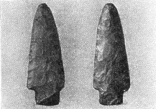
FiG. 8. Flint Javelin Head from Ballacross, Arbory ; 3½ in. long.
Although some of the more primitive coarse, heavy, and unornamented examples of pottery, not turned by wheel, which have been exposed by agricultural operations, may have belonged to food vessels of this period, it is difficult to discriminate them from those of a later date, and our opinion must be guided by their surroundings and associations. When, however, any remains of ornamentation are to be seen, its character enables us to date the period with some degree of certainty.
A few small and very rudely formed dug-out canoes which have been found seem to belong to the Neolithic period. One now in Castle Rushen is from Seafield, Santon. Another from Tosaby, St. Marks, appears to be now lost. The most perfect example met with is that found in 1884, at Ballakaighan, German (fig. 9). It measured just over 14 ft., having at one end 2 ft. 3 in., and at the other I ft. 11 in. of solid timber; the inside width is about 2 ft. tapering to 16 in. ; the highest part is just 14 in., and, inside, 10 in. In the thick end a hole is pierced, perhaps for passing a thong or rope of hide through. Many such canoes have been found along the margin of the Clyde about Glasgow, some from " a single oak stem, hollowed out by blunt tools, probably stone axes, aided by the action of fire; a few cut beautifully smooth, evidently with metallic tools. . . . Those most roughly hewn may be relics of the Stone period; those more smoothly cut of the Bronze Age."8

FIG. 9.-The Ballakaighan dug-out canoe.
The Ballakaighan canoe, which, since our first Edition was published, has been purchased by the Manx Museum, and is now temporarily in Castle Rushen, rested by the south side of a considerable area-about 60 ft. by 9 ft., and 5 ft. in deepest part-of burnt soil, stones and charcoal. Alongside, south of the canoe, at a lower level, was a row of flat stones resting on the soil and forming the edge of two cists, the smaller of which was uncovered, but the other capped by a slab of hard trap rock, 5 ft. 6 in. by 2 ft. 6 in. Beneath this, for a depth of 2 ft., was loose soil with twigs and nuts of hazel ; at the bottom, blue clay with broken quartz on the 8 surface. The smaller cist, also filled with loose soil, was divided from the other by a large flat stone set on edge ; its more southern wall, however, was built of flat stones in four courses, and this was continued in a curve westward and southward. Two large pieces of oak lay horizontally about 2 ft. 6 in. below the surface; one, which crossed close by the W.S.W. end of the canoe, lay diagonally with it about S.E. to N.W., and measured 82 ft. by 10 in. diameter at its widest. The other, almost at right angles to this, its S.W. end about 4 ft. off, passed diagonally beneath the smaller cist. Thirteen piles of oak were disclosed, the broken tops of which were about level with the bottom of the canoe. The largest measured 3 ft. in length, of which about 18 in, was formed into a point, very clean and smooth to have been done by an axe of stone ; its diameter was 10 in. This was about 50 ft. from the edge of the brooghs, and about 200 ft. above sea-level. Inland, to the S. W., further traces of burning have been found, and more oak piles, while throughout the field great numbers of flint flakes and cores have been picked up.9
The transition from the Neolithic to the Bronze stage of culture must have been gradual in the Isle of Man. That the earlier people were not exterminated by these first Aryan immigrants is evident from the fact that the small Iberian type may still be recognised in the Manks folk of to-day ; as also may the taller round-headed type of the Bronze Age man.
Evidences of the transitional stage are to be seen in some sepulchral monuments of intermediate type, such as " King Orry's Grave," Laxey ; a cairn on Ballachrink, Dhoon, Maughold ; a passage grave at Kew, German; perhaps the circle on the Braid, near Slieau Chiarn, Marown ; and one or two more. One of the most curious and interesting of these is the circle of cists on the Mull Hill, above Port Erin, and as we made a careful examination of this some years ago 10 and as it is the demand for copies of our paper now long out of print that has caused us to write out the present notes, we shall re-print here with some slight alterations and corrections that former account published in 1893.
At the south end of the Isle of Man, next to the Calf Island, is a group of low rounded hills which stand out rather prominently from being nearly completely separated off from the remainder of the land by the narrow neck of low-lying country which runs from Port Erin on the west to Port St. Mary on the east. This is the Mull or " Meayll " (pronounced " Mule," derived possibly from the Scandinavian " Muli," a muzzle or snout, or perhaps more likely from the Celtic" Meall," = a hill or rising ground of rounded shape ; so " Meaull " in Galloway, and " Moyle " in Ireland), a district very well suited to be a stronghold in savage times as it is surrounded on three sides by lofty and precipitous sea cliffs extending from the formidable Spanish Head and the Chasms round by the Calf Sound to Port Erin, while on the fourth side is the low neck of land which, before the arrival of man in the district, had been submerged and after that for a long time was no doubt a swamp or morass. This commanding situation probably rendered it a favourable habitation in early times- possibly it was a last refuge in the south part of the Isle of Man of the pre-Celtic race-and on the higher parts of the hills, still uncultivated, we can trace the lines of ancient boundary fences dividing the moorland into areas, we can find the remain, of at least three prehistoric villages or clusters of huts, and near the highest summit, now known as the Mull Hill, is the remarkable stone circle we are about to describe, an ancient burial place probably common to the neighbouring villages (see fig. 10).
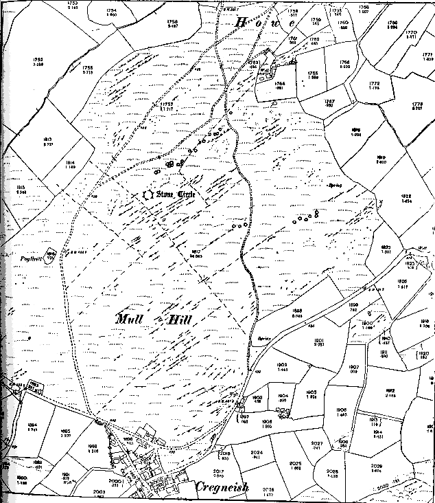
FIG. 10. Reduced, with additions, from the 25-inch Ordnance Survey- to show the position of the Stone Circle and the Group of Huts on the Mull Hill.
In form and arrangement this circle is we believe unique, and although it has long been known to local antiquaries, it has never, we consider, been adequately described or systematically explored. The late Mr. Jeffcott of Castletown gave an account of it to the Cambrian Association in 1865, and this is quoted, and an imperfect figure given, by Fergusson in his " Rude Stone Monuments," p. 158.
To this account, which is not quite accurate, he adds that from simple inspection it is evident that these cists must at one time have been covered with earth, and if so, thinks that so far as one example can go they would tend to prove that the circular vallum at Avebury and many other localities was a place for the deposit of bodies. He remarks upon the two gaps or openings in the circle opposite one another, as at Arbor Low and Penrith, but suggests that they may have arisen from the removal of cists. As the result of our examination we can state definitely that that is not the case - the openings were certainly left intentionally.
Further, the Manks Archaeological Commissioners in their report to Sir Henry Loch in 1878 catalogued this circle and recommended that a careful excavation should be made. This recommendation we endeavoured to carry out during August and September, 1893, having first duly obtained permission from the proprietor ; and although we found that some parts at least had evidently been formerly disturbed by irresponsible persons who have left no record-probably early diggers for treasure without any archaeological knowledge or interest-still we unearthed a very perfect series of eighteen cists, and some remains of pottery and implements, and are now enabled to put on record a detailed description of this, one of the most interesting of ancient Manks monuments, and to draw more certain deductions as to its age and purpose.
Our general plan of the Mull Hill (fig. 10), on the scale of about 8 in. to the mile, shows the position of the stone circle, the sites of the hut villages and the lines of the ancient boundaries.
Of the little hamlets, or clusters of hut-dwellings referred to we have discovered the sites of three, containing each the foundations of 4 to 16 huts. The largest and most interesting of these groups (See fig. 10 just above " Stone Circle ") still retains amongst the country people its name " Lag-ny-Boirey," hollow of trouble, or lamentations, or strife, or, as the people put it, of " botheration." 11 When or why this name was given one can now only conjecture, but as it is good Manks, it seems to imply that the place was still known as an inhabited village within historic times, and that the ill reputation of an earlier and despised race (? Neolithic) still clung to it. 12
The first of these groups of huts lies about 330 yds. north of the cairn at the summit of the hill, and is immediately at the foot of the ridge on which the stone circle stands, in a sheltered hollow looking towards the north. The hut foundations of earthen banks and large unhewn stones are overgrown with heather and gorse, and lie in a straggling row along the eastern side of one of the ancient boundary fences; they extend over an area of about 130 yds., and are placed at distances apart of from 3 to 24 yds. In at least three instances there are groups of 2 or 3 huts adjoining, so that one wall would serve for two. One of these which we excavated measured inside 8 by 3 yds., and appeared to consist of two dwellings. The foundation stones were still in position and marked out a roughly rectangular building, with a division across the middle, having at the S.W. end what was probably an entrance passage 4 ft. long by 3 ft. wide, but partly built up like a step at the outer end. At a depth of about 18 in. we came on what was clearly the ancient floor with some charcoal on it and fragments of pottery from 1/8. to ¾in. thick. The pottery evidently belonged to a crock-like vessel with a lip, and a reconstruction showed the mouth to have been about 4½ in. across. In January, 1905, we excavated another at the N.E. end of the same line. It was circular, about 8 ft. in diameter, formed of large stones set on end. In this we found a well-formed flint flake and a small flint chip.
Another part of this village which we excavated proved to be a group of 4 huts varying in inside diameter from 6 ft. to 12 ft. 6 in. The largest, of which the foundation stones all appeared to be in position, was rectangular and had an entrance about 3 ft. square at the N.E. end ; it was separated from the others by a wall 3 ft. thick. A few small flat stones were found on part of the ancient floor, but nothing that was an undoubted hearth. In one of these huts was found a flint scraper, in another a small flint flake with two cutting edges. Perhaps a more remarkable find was a stone 5½, in. by 1¾ in. by ¾ in., of which one face was polished, having probably been used as a whetstone for polishing flint implements, or as a rubbing or polishing stone in curing and preparing skins. There were also found some small flints and quartz pebbles which may have been used for striking a light. Possibly the white quartz pebbles, a great number of which were also met with in the cists of the circle, had been used as " pot-boilers." If the rudely baked clay vessels were not able to stand much fire the contents may have been cooked by dropping in these stones previously heated on the hearth, or, perhaps they were used to line the " fire-holes " or rude ovens in which the object to be cooked would be placed, wrapped in clay, and then covered over. This explanation may account for the small pebbles in the huts, but scarcely for the great numbers found in the graves (see below).
Somewhat further east than " Lag-ny-Boirey " we found the circular foundations of 3 or 4 more huts measuring from 8 to 12 ft. in diameter, and like the others these are on the line of one of the ancient fences (see fig. 10). Lower down the hill and still further to the east are half a dozen more such but foundations. Their outside diameters are from 4 to 5 yds., and the stones forming them-about 12 in a circle-measure about 4 ft. by 2 ft. and project about 2 ft. above the surface ; they are unhewn blocks of the same Manks slate of which the fences and the circle and the rock of the hill are composed. Like the other huts these are also on the line of one of the ancient fences and (also like the rest) occupy a sheltered situation looking to the north, i.e., with an uninterrupted view across the lower ground towards the rest of the Isle of Man. This site has the further advantage of being just above the spring which is known as " Chibbyrt-ny-Garval," Horse-well.
We have found indications of the foundations of still other huts around the hill, and no doubt some are completely overgrown and lost.
One is tempted to suggest that we may have yet another of these ancient villages existing to this day in Cregneish, on the other slope of the hill, about 250 yds. to the south of the cairn, and usually regarded as one of the very few typical old Manks villages left (fig. 11). Possibly some indication of this may yet be found by a careful examination of the gardens and bases of the cottages at Cregneish, but in the meantime it is interesting to note that Sir George Head writing in 1837 in his " Home Tour " (Vol. II., p. 23), speaks of a small hamlet near Spanish Head and between " Port-le- Murray " and " Port Irons " which must be Cregneish as "composed of edifices so rude, that it is really hard to predicate of the houses at a little distance, whether they are masses of rock or human dwellings."
Fig. 11.-View of Cregneish from the south.-From a photo.
The most interesting relic on the Mull Hill is the stone circle which is situated a little way down from the summit at a distance from the cairn of 250 yds. in a direction 10° west of north, and at a height of about 500 ft. above the sea. Mr. Jeffcott gives this burial place the name of " Rhuillick-y- lagg-shliggagh," graveyard of broken slates. The word " Rhuillic " or " Relic " however is always applied to a Christian cemetery, and this name we ascertained belongs without doubt to the site of a Keeill and burial ground down at the Calf Sound a mile or so to the south-west, and we had no difficulty in discovering the true name of the Mull Circle, for it is still in actual use among the fishermen, who take its prominent stones in a line with the Calf as a mark for one of their fishing grounds, and apply to it the name of the ancient village in the hollow immediately below (which of course is not visible from the sea), Lag-ny-Boirey, or hollow of botheration.
The circle (see fig. 12) is formed of six symmetrically arranged sets of cists or stone chambers, each set-for which we propose the term "tritaph"-being composed of one radial cist and two tangentially placed. Three tritaphs form the eastern half of the circle and three form the western, leaving considerable gaps or entrances at north and south. The south entrance measures 16 ft. in a line with the external circumference, while the corresponding opening at the north is 77 ft. across. The north to south diameter measures 50 ft., and the east to west 56 ft. A circular mound of loose stones and earth packed on to the external circumference of the cists slopes to 3 or 4 yds. beyond the above measurements, and the whole may have formed a " disc-shaped Barrow," such as there appear to be traces of elsewhere in the Island. The Museum Trustees in 1911 had a trench cut across from north to south which revealed rock at a depth of 3 ft. below the surface at a point immediately outside the northern opening, and, at a point about 10 ft. outside the southern opening, rock was met with at a depth of 18 in. The artificial filling in of rubble was found to be now about 2 ft. deep throughout rising, however, gradually to 2 ft. 9 in. at the centre.
There is some indication of a cist or chamber of some kind having formerly been in the centre, but it has evidently been previously disturbed and is no longer recognisable. Although there are slight differences in size and proportion between the different tritaphs they are all built on the same plan, viz., two large cists placed end to end running along the circumference of the circle, and one rather longer narrower one directed radially outwards from the place of junction of the two former. The arrangement then is a triradiate one ; we shall call the end of each cist which is nearest the common centre of the tritaph " proximal," the remoter end " distal." The tangential cists are composed each at the distal end of an outer end stone about 3 ft. wide, of two side stones or monoliths placed on edge and measuring up to 8 ft. in length, and of an entrance at the proximal end. This entrance consists of a pair of upright pillar stones one at each side, measuring 1.8 to 24 in. across, and standing within and partly overlapped by the large side stones. Sometimes at the base of the pillar stones and stretching between them is a flat slab, sill or step, and sometimes traces of a low wall built of smaller stones. In no case is this end closed by a single large end stone.
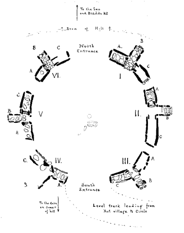
Fig 12 - Plan of Circle of Tritaphs
Between the proximal ends of these tangential cists and running out at right angles to them is the third or radial cist of the tritaph. It is formed of two pairs of small side stones each 1 to 2 ft. across, and in all cases is open at its distal end where in some cases there are a few steps, formed of rough slabs, leading down from the surface of the ground to the floor. No gateway is present in the radial cists, which thus differ constantly in several points of structure-of sides, and of both ends-from the tangential cists. The average size of the tangential cist is 5 ft. 9 in. by 2 ft. 8 in., and of the radial cists 7 ft. by 2 ft. 3 in. The floor, at a depth of 18 to 24 in. below the present surface, showed in all cases indications of a pavement of flat stones, on the average about 1 ft. across and 1 to 2 in. thick ; that these had been laid as a pavement and were not stones fallen in was evident from their general appearance and arrangement, and from the fact that some passed partly under the large side stones. All these stones, from the large monoliths to the small gate posts and floor stones, are of the grey clay slate of which the mountain is formed, some of which crops out close at hand with highly inclined cleavage planes, so that probably large slabs could be readily split off with wedges and then dragged or rolled to their present positions. No lintel, impost, or covering to the cists now remains, these having doubtless been long since removed for building and repairing fences. This removal and the fall of rubbish consequent thereon would in part account for so much broken pottery in the cists. Above the flooring of flat slabs and the buried urns, ashes and flints, the cist appears simply to have been filled in with loose stones and earth up to nearly the top of the side stones (see fig. 1 on fig. 13). The burials were evidently all by cremation, 2 to 5 or more urns being deposited in each tangential cist or in the proximal end of the radials-we met with no such remains in the distal part of any radial cist.
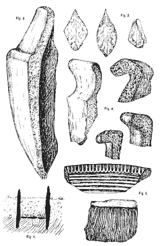
Fig 13 - From the Mull Hill Stone Circle (From sketch by W.A.H.)
Altogether we have been able to distinguish the remains of at least 26 distinct urns, all however in a fragmentary condition. With this pottery were some fragments of calcined bones, ashes and loose charcoal, also compacted lumps of bone, ash and charcoal, with a certain amount of greasy black matter. A few flint instruments were met with, including three arrow heads (fig. 2 on fig. 13), at least five knives, a scraper, and some broken pieces. In each cist also were found a number of rounded white quartz pebbles, from the beach, measuring 1 to 6 in. in diameter. These were found scattered through the grave without obvious arrangement, although they may originally have been carefully deposited on the floor around the urns or in some definite manner; several shore pebbles of larger size were found in the surrounding bank. In some other ancient burial places in the Island similar white quartz pebbles, evidently brought from the sea-shore, have been used. Can this be the origin of the superstitious dislike the natives still have to the use of the " clagh-bane " or " white stone " ? Fishermen, for instance, will refuse to go to sea in a boat which has a white stone in the ballast.
In one cist-VI.A of our plan (fig. 12)-we found immediately beneath the pavement or floor a hole measuring 12 in. in diameter at the mouth and 12 in. in depth, filled with a fine dark soil like that above the floor of the cist, while with this exception all the floor stones rested on the undisturbed surface of the harder and more yellow mountain soil. This suggested that in this case an urn had been buried in the soil under the floor, and in fact nearly all the pieces of pottery and the flints were found beneath the floor stones. How far this position is due to the cists having been disturbed before, the contents turned over, and the urns broken it is impossible to say.
Now we shall note briefly any special characters of the tritaphs, commencing at the north-east corner (see fig. 12). We label the tritaphs I. to VI., and the cists in each A, B and C-in each ease B is the radial one.
In I.A we found an old worn shell of Littorina littorea. also fragments of pottery which proved on examination to belong to at least 5 different vessels measuring from 9 to 12 in. in height and about the same in widest diameter. Other fragments, some evidently belonging to the same urns, lay in the central space between A and C.
In II.A in its north-west corner were loose pieces of charcoal and some burnt bone fragments, also traces of a black oily substance possibly the result of charred animal matter mixed with earth. We were told that 20 years before a man named Fargher had dug a perfect urn out of cist C. No description or record of it was however kept, and the urn itself has disappeared. We think that it was in or beside this tritaph that in 1882 Mr. F. Swynnerton picked up a small beautifully finished flint arrow head.
In III.B a small flint scraper was met with, and in C some pieces of pottery belonging to 5 urns and 2 broken knives. The space between this and the next tritaph, an interval of 16 ft., was tried in various places with spade and pick, but was found to be undisturbed mountain soil. It evidently formed the southern and main entrance to the circle (see fig. 14). A level track, like a road way, leads from here in a curve down the slope of the hill to the hut village (see figs. 10 and 12).
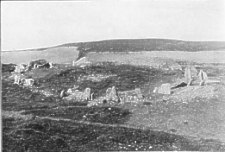
Fig. 14,-View of stone circle from the south-east.
The southern and northern gaps, and the groups of stones forming tritaphs, are
easily seen.-From a photograph. by Prof. G. S. Brady.
Tritaph IV., the first on the west side going from south to north, had evidently been disturbed before, and some of the stones had been displaced and removed, but still on clearing them out the shapes and sizes of the cists were readily distinguishable.
The next, V., was nearly perfect. In A some fragments of pottery belonging to 3 urns, calcined bones, 2 flint knives and 2 arrow heads were found, and in the central space between A and C some pottery. In C were some fragments of pottery (at least 2 vessels) at the S.W. and N.E. corners, also a flint knife and another arrow head.
Tritaph VI. was also a perfect one, and cist A particularly so. In it some flints and pottery were met with in the N.W. corner, and in the centre was the hole excavated under the floor which had evidently once contained an urn and which is referred to above (fig. 13). In C some flints and fragments of pottery were found between the entrance pillars. This completes the circle. Between tritaphs VI. and 1. is a space of 18 ft. which we tried carefully with pick and spade and found nothing but soil and small stones. It had evidently been left intentionally as the northern opening of the circle, facing down the hill towards Port Erin Bay and Bradda Head.
With respect to the pottery, we found in all remains of at least 26 vessels the appearance of which showed that they had been used as cinerary urns, and along with them the remains of ashes, charcoal and calcined bones. With the exception of tritaph IV., which had been more disturbed before our examination than any of the others, and of II., from which, however, a perfect urn had been formerly taken, we found some pottery in every tritaph, but with two exceptions it was always in the tangential cists. The urns numbered from 2 to 5 in a cist, but there may have been more. From the fragmentary remains the vessels seem to have been all between 9 and 12 in. high and the outside diameter at the mouth varies from 8 to 11 in. They show some diversity of shape, colour, lip and surface (Figs. 3-5 on fig. 13). About seven vessels show traces of patterns. These are of the simplest kind, consisting of lines impressed diagonally or perpendicularly across the lips (Fig. 5 on fig. 13) and of lines diagonal, horizontal and perpendicular either drawn with a pointed stick or formed by punctured holes on the walls, such as are usually regarded as of Bronze, Age. There is no colouring save that given by firing and stains. The paste appears in all to contain a mixture of the local slate and quartz, with a good deal of mica, probably from disintegrated granite which would be found in the boulder clay in the neighbourhood. With respect to shape the most notable thing about the vessels is that several of them appear to have had broad overlapping rims or lips (Fig. 4 on fig. 13), not a common type in the Isle of Man, and some also median bands and grooves. On the floor of one of the huts we found remains of a couple of small earthen vessels similar in colour, material and style to those met with in the cists.
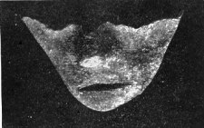
FIG. 14.-Clay model of human face, from Lag-ny-Boirey Mull Hill- slightly enlarged.
It may be added that since our exploration in 1893, we have found further examples of flints and pottery in a couple of other huts in Lag-ny-Boirey excavated in 1896 with a view to the visit of the British Association that autumn. These pieces included the greater part of a small mask of the human face (fig. 14) measuring 5 cm. across, from cheek to cheek, 3 cm. in length, from broken bridge of nose to point of chin, and 1.-5 cm. in thickness of clay at the widest part which is below the left eye with the exception of the nose which projects 1.-2 cm. beyond the cheek. The clay of which this pottery face is made is very different in character from that of the coarse pottery previously found in these huts, and this may therefore be of a different period or it may possibly be a fragment of some Roman vessel brought over from the mainland or from the Mediterranean.
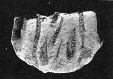
FIG. 15.-Fragment of (?) Mediaeval Pottery, from Lag-ny-Boirey, Mull Hill-slightly enlarged.
We also found in these huts three fragments of mediaeval glazed pottery, forming part of a flattened handle of some large vessel. The piece figured (fig. 15) measures 5 cin. in greatest length by 4 cm. in the width of the band-like handle, the thickness of the wall of the pot being 5 mm., and the photo- graph shows the type of ornamentation. The colour is yellowish brown. These fragments were found at a higher level than the ancient floor, and may be taken as an indication that some of the huts were occupied on into historic times.
The flints obtained have already been enumerated. The arrow heads were all of the same type, leaf-shaped, showing secondary working and careful finish (Fig. 2 on fig. 13). Two are worked on both faces, the third, which has lost its point, is worked only on one face. The knives are all of the same type, the flat face left intact, the convex trimmed by secondary working on one edge only. The largest measures 2 11/16 long by 1 1/16broad and 3/4 thick.
The scrapers are small and rudely made-. One of yellow flint measuring 11/8 in. by 1 in. and 5/16 thick has the bulb of percussion at the broad end, the edges which are sharp and narrow are rounded to a point, and only the edges show secondary working. A scraper of about the same size from one of the huts shows almost no trace of secondary working. An awl, or perhaps a knife, from the huts resembles one figured in Evans' " Ancient Stone Implements," figs. 235 and 239, but is smaller and broader in proportion. The point and the butt are rounded and both edges sharpened, but it shows very little trace of secondary working.
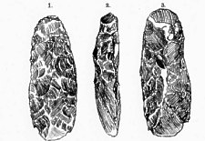
Fig 16.-Three views of adze, from the Mull Hill. From a sketch by Beatrice S. Herdman.
1. Face, carefully chipped to shape.
2. Side view, showing shape of cutting-edge,
3. Back, with ridge 13/4 in. from cutting edge ; at butt end, a piece of the
crust of the flint core remains ; side edges show secondary working.
A much larger flint implement than any of those we found in the stone circle or the hut village, and which might be called an adze (fig. 16), was picked up a few years ago by Mr. Nixon on the Mull Hill in a field adjoining his house, and presented by him to the Manx Museum together with a flint arrow head found in the same field.
On the whole, these remains seem to show that the people who inhabited the ancient villages on the Mull and erected and used the stone circle, were probably in a transition period, or at the beginning of the Bronze Age, living in small communi- ties of 4 to 16 families, that they occupied the locality over a lengthened period, and were there when the later Celtic population settled in Man. They used pottery of a rude kind, made by hand, of materials obtained from the spot, for domestic purposes and as urns in which they deposited the ashes of their dead. The stone circle on the hill above the villages was used by them as a place of sepulture, and the only modeof burial there was by means of cremation. They hunted and fought with flint-tipped arrows, used flint scrapers to clean and prepare the skins of animals for their clothing, and the flint knives no doubt for various other purposes. In regard to the ceremonies of burning their dead and the burying of the ashes we can only conjecture, but the size and nature of the cists, the presence of the numerous quartz pebbles, the buried weapons and implements deposited with the ashes, all would seem to indicate the funeral rites of a people imbued with some religious ideas however primitive. The discovery of several urns in some of the cists proves that these had been opened and. used for as many separate burials, and this is a characteristic of late Neolithic Age, graves of the succeeding period being formed of cists which, upon receiving the body or burnt bones were completely covered in and not opened for subsequent burials. On the other hand, cremation though not unknown in the earlier period was characteristic of the later, and the decoration of the pottery on such fragments as have been recovered is distinctively of Bronze Age. The fact that the radial cists or "Passages" to the graves could not have been for actual use, that each tritaph is in fact the model of a passage-grave, points to a late period if in Neolithic times. Indeed the whole appearance of the monument suggests a transition between the Neolithic and the Bronze periods. We have done our best to make the examination of the huts and stone circle of the Mull Hill as thorough as possible, and what is perhaps of nearly equal importance we have lost no time in placing the results on record for future reference. We trust the proprietor may now be induced to make over the guardianship of this unique relic to the Trustees of the Manx Museum, in order that it may be thus preserved as a National Monument of interest not only to Manksmen but also to Archaeologists in general.13
Returning now to other parts of the Island, we may mention here, as of still undetermined age: (1) A large circle of small and comparatively inconspicuous stones high up on the lonely shoulder of Bradda Mountain which overlooks Fleshwick, and (2) a very neat little circle, known as Cronk- Carran, formed of regular, for the most part, upright stones, and only a few yards in diameter, which is placed on a grassy patch part way down the cliff near the Chasms at Spanish Head. These have not been excavated, but will probably prove to be of Bronze Age.
The group of monuments commonly known as "King Orry's Grave " (fig. 17), in Laxey, appears to have consisted of a large cairn of stones, 30 ft. in diameter, out of which arises a tall thin conical slab about 10 ft. high ; from this extends eastward a line of cists, formed of two rows of flat boulders, set edgeways, 4 ft. apart. About 40 yds. eastward across the high road are the remains of another large tumulus. Mr. Barnwell, Secretary to the Cambrian Archaeological Association, which visited the Island in 1865, says that human bones, the skeleton of a horse, an iron sword and horseshoe were found in opening this cairn, 30 years previously, but Dr. Oswald, a local antiquary who was in a position to know, mentions only a " tooth and remains of a horse."
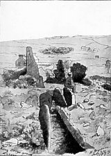
Fig 17. "King Orry's Grave." From a sketch by Sir Henry Dryden.
The Ballachrink Cairn, Maughold, consisted of a circle of massive stones, 10 yds. in diameter, on the north-east side of which was an oblong platform about 4 ft. high. On its south-east side was a line about 38 ft. long of three or more cists, in which were found remains of a skull and other human bones, and a good deal of broken pottery ; at either side was a line of larger stones set on end. The largest piece of pottery must have been part of an urn (food-vessel), about 7 in. diameter at the mouth. About 1825, when a sketch was taken by Dr. Oswald for the " Vestigia antiquiora " (Manx Soc., Vol. V., p. 66), the monument was surrounded by a rough wall of large stones. The covering consisted chiefly of quarried stones laid flat over each other, about 4 ft. high, and an incomplete circle stood at the western end. The length from east to west of the remains is 105 ft., breadth at west end 50 ft., at east end 40 ft. The western part, including the circle, is 70 ft. long, the east portion 35 ft., and lower than the other. There are also traces of a cross wall. The arc of the semi-circle is 70 ft., and the distance between the outer stones 32 ft. Oswald, 1860, had seen the platforms, the stones of which were used in building a new house. The circle remained untouched, its diameter being 10 yds.-the circumference of the whole ruin is 90 yds. The largest stones are 10 ft. high, and between the two central ones is an opening into the first cist 20 in. wide. In this cist, 10 ft. long and 5 ft. 6 in. wide, with side stones leaning towards each other at the top, we found black carbonaceous and grey unctuous earth, with fragments of charcoal. Under the side stones were pieces of human bone-portions of a skull with the suture open, upper jaw bone, with teeth regular and sound, evidently of a young person, and other fragments ; also pieces of at least two urns. The eastern cist also contained bones and fragments of a smaller urn. The other chamber contained similar black carbonaceous and grey unctuous clay with charcoal and a few pieces of flint.14 In form this remarkable monument shows some resemblance to the Neolithic long Barrows found elsewhere in the British Islands. We are glad to say that this has now (since 1913) been placed under the guardianship of the Museum Trustees.
The remains marked on the Ordnance maps, at Kew, German, consist of an avenue of upright stones leading to a tumulus which has not been opened.
The monument on the Braid, Marown 15 is a large circular mound of earth and rubble about 3 ft. high, with slabs on end set around (fig. 18). The diameter, inside, is about 12 yds. An entrance on the south is distinguished by two upright stones facing each other, about a yard apart. Alongside on the N.E., and apparently associated with it, is a remarkable avenue about 36 yds. low, by 10 yds. wide, formed by two substantial embankments of earth and large stones. Between this and the circle are two rings of stones on end, evidently remains of a tumulus from which the soil has been removed.
These are not marked on the plan (fig. 18), having been disclosed since it was made. In the northern bank, where it is broken and set at an angle, the late Mr. Rigby in 1907 found dry walling about 3 ft. high along the lower side, in which were two carefully built vaulted chambers about 24 in. by 18 in. by 30 in. deep, which may have been deposit places for urns, but nothin r was found lit them.
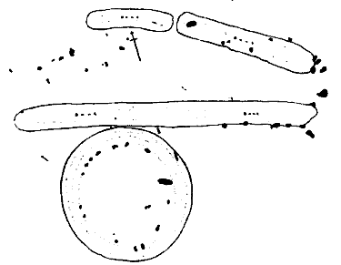
Fig. 18.-" Mount Murray " Circle : Plan of the, remains on the Braid, Marown-after Sir H. Dryden.
The remains of a circle which may have been of similar character are to be seen on the side of the hill above Cxlion l'eeill Vale which opens into Glen Aldyn, Lezayre, hear Ramsey. There is a ring tumulus about 40 ft. in diameter consisting of a circle of white quartz boulders. The boulders average about 3 ft. by 2 ft. and 24 in. high, and originally would have been covered with soil and rubble. On the south a portion of the rubble mound remains, exposing a cist (see fig. 1.9) 3 ft. by 1 ft., and 2 ft. high (inside measurements). There were other similar cists, containing urns and ashes, which were exposed when the greater part of the surrounding circular mound was removed in making the mountain road about 300 yds. above. It is possible that the circular mound on the Marown Braid, if excavated, would show similar chambers.
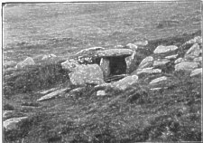
Fig. 19.-Stone Cist at Glen Aldyn.-Photograph by M. McWhannell.
It is impossible in the total absence of human remains to say whether Neolithic man here was of one race, but it seems likely that both the Mediterranean and the Alpine stock were represented and occupied the Island for a lengthy period before the arrival of another race. Unfortuneately our knowledge of the Bronze Age people is similarly limited,and whether their implements and stage of culture were first introduced to the earlier inhabitants by means of commerce and intercourse with the people of the surrounding lands, or by means of an incursion and settlement of the new race, and at what period this occurred, can only be determined by a more systematic examination. We may expect further light to be thrown on this and kindred questions by the researches of the local Committee, appointed to make a detailed Archaeological Survey of the whole Island, whose work has already taught us much with respect to the more recent period which they are now investigating.
1 In regard to the separation of stone implements into axes,
colts, lances, knives, scrapers, awls, &c., it is important to note that
Dr. W. E. Roth, writing on the Ethnography of Queensland, says that the modern
savage certainly does not recognise these fine distinctions.
In the case of the earlier and ruder forms at least it may well have been that
the shape of the detached or chosen fragment was more or less accidental, and
it was probably used indifferently for various purposes as was found convenient.
2 Yn Lioar Manninagh, I., 2, 90, 131, 212.
3 Yn Lioar Manninagh, I., 2, 262.
4 Yn Lioar Manninagh, III., 635.
5 See " Early Man in Britain," p. 288
6 Yn Lioar Manninagh, III., 373.
7 Manx Society, Vol. XV. p. 98, and plates.
8 Glasgow Archæological Society, Vol. II, p. 46.
9 Yn Lioar Manninagh, I, 36 ; part 2, 78.
10 Trans. Liverpool Biological Society, Vol. VIII, p. 159, Pl. X.-XII. Yn Lioar Manninagh, II, p. 117.
11 When we laid an account of these excavations before the meeting of the British Association at Nottingham in September, 1893, Dr. Munro, President of Section H, suggested " scolding " as a better rendering of the word.
12 Compare the views of Neolithic Man in Ireland held by a later race, as shown m the traditions of the physical characteristics of these early colonists of Ireland (the Firbolgs, identical with the Iberian population of the Scilly Isles, Cornwall, and South Wales, and of the whole of Britain and Ireland in the Neolithic Age) quoted in the preface to McFirbis's Book of Genealogies :-" . . . Everyone who is black-haired, who is a tattler, guileful, tale-telling, noisy, contemptible . . the disturbers of every council and every assembly, and the promoters of discord among the people, these are the descendants of the Firbolg." Celtic Scotland, Skene, Vol. I., p. 178.
13 The above was written in 1893. We are happily now able to record that the owners have placed this circle under the guardianship of the Manx Museum and Ancient Monuments Trustees, by whom it was, in 1911, railed in so as to preserve it from injury. The Trustees re-excavated the tritaphs I. and IV., and have left there exposed to view in order to show their nature and character.
14 Reliquary, Vol. XXV., Pl. XIX., 1884. Trans. Soc. Antiq Scot., Vol. II., Part 2.
15 Sometimes called Mount Murray Circle.
|
|
||
|
|
||
|
|
||
|
Any comments, errors or omissions gratefully received
The Editor |
||