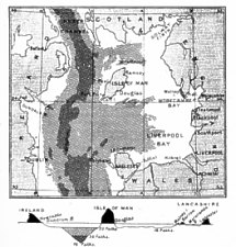
Fig. 2.-Sketch Map and Section of the Irish Sea-Basin
(Prof. W. A. Herdman, Report Brit. Assoc., 1896).
[From Illustrated Notes on Manks Antiquities, 1904]
THE Isle of Man is interesting from various points of view, and many of the more or less scientific summer visitors to its shores must often have found intellectual delights in its marine biology and its botany, in its rocks and fossils and in tracing the survival of ancient customs and the still earlier remains of prehistoric Man. The past history of the land and the people is so constantly and so prominently brought before the eye and the imagination by Tynwald Hill and Rushen Castle, by early Celtic and Scandinavian carvings, by ruined " keeils '' and holy wells, by tumulus and standing stone, by cup-markings, archaic pottery and fields of chipped flint, leading back to the remains of extinct animals and the work of the great ice-age, that the observer naturally desires some guide which will enable him to place and classify, however imperfectly, these ancient records from the soil and the rocks. Although these unwritten records may not enable us to form anything approaching a complete and satis fying history, they yield welcome glimpses into the past state of our land, and show us something of the habits of races that have contributed to our ancestry.
Archaeology traced back to its beginnings merges into Geology; and we find on examination that the Isle of Man has been a. land-mass since very early geological times. The precise age of the oldest stratified rocks forming the foundation of the island is very difficult to determine owing to the absence of undoubted fossil remains and the alterations due to heat, pressure and earth movements. The " Manx slates " which build up its back bone from Bradda Head to North Barrule (fig. 1, Map) are however certainly not later than Lower Silurian, and are placed by Mr. Lamplugh in his recent Memoir 1 as Upper Cambrian, with a query; and this central ridge which constitutes the mountain ranges seems to have been an insulated mass even as early as the beginning of the Carboniferous period. " This prototype of the present island appears afterwards to have been enfolded and obliterated by the sediments of later times ; but with the process of denudation the old ridge has once more emerged from beneath this mantle." The physical features of the district, such as are necessary for an understanding of the past history, can best be given by quoting a few paragraphs from Chapter I. of Mr. Lamplugh's authoritative Memoir, as follows:
" Its insular character is as well maintained in its physical as in its geological features. The erosive agency of the simple drainage system descending radially to the sea from the central hill-range, together with that of the waves which surround it, is adequate to explain all the contours of its present surface. It must indeed frequently during its history have been re-united to the mainland by a continuous land surface; but at such times it probably still retained in some degree its characteristic individuality, and arose above the surrounding plain as a hilly tract with a self-contained drainage, although its streams may then have been tributary to a larger river system lying beyond its limits."
Fig. 2.-Sketch Map and Section of the Irish Sea-Basin
(Prof. W. A. Herdman, Report Brit. Assoc., 1896).
"The sketch map, fig. 2, will serve to recall the position of the Island as regards the neighbouring shores. Its northernmost point is 16 miles distant from the nearest headland of the Scottish coast, while its closest approach to the Cumberland shore is 31 miles, to that of Ireland in Co. Down 31 miles, and to the Welsh coast near Holyhead 45 miles. The same map shows roughly the contours of the surrounding sea-bottom. To the eastward of the Island the depth is nowhere more than 20 fathoms, to the north ward it rarely reaches 30 fathoms, to the southward it usually ranges between 30 and 50 fathoms, while to the westward midway to the Irish coast there is a long narrow trough descending to over 70 fathoms."
" As at present constituted, the Island, with the detached islet of The Calf off its south-western extremity, contains 227 square miles (140,325 acres), of which 170 square miles, or three-fourths of the whole, are occupied by the slate and greywacke rocks, probably of Upper Cambrian age, composing the hilly massif. Strata. of the Lower Carboniferous age occur in a small basin of 7 or 8 square miles at a low elevation in the South of the Island, and a narrow strip of red sandstone, probably belonging to the same period, borders the coast for two miles about midway upon the western side. The northern extremity consists of a low-lying tract of about 45 square miles, which is an addition made to the Island in glacial times by the deposition of great masses of glacial drift upon the pre-glacial sea-floor. Deep borings through this drift have recently revealed a rock-floor of Triassic, Permian, and Lower Carboniferous strata at a considerable depth below sea-level."
" The Island is irregularly oblong in shape, with its longer axis running N.N.E. to S.S.W., which is the direc tion of strike of the slate rocks. In this direction, from the Point of Ayre to Spanish Head, (the land has a length of 30 miles, while the breadth of its wider central portion varies from 8 to 12 miles. Excepting in the well cultivated northern plain there is little flat ground. In the interior the physical features bear much resemblance to the southern uplands of Scotland. The hills are steep, but not generally craggy, and are arranged in long, grassy or heather-covered ridges running with the longer axis of the Island, with broad intervening valleys. The highest of these ridges commences in the vicinity of the eastern coast near Ramsey, and is practically continuous to the south-western coast north of Port Erin, but is broken across in one place by a deep transverse valley, which intersects the Island between Peel and Douglas. North Barrule, with an altitude of 1,840 feet, forms the north eastern extremity of this ridge, which culminates 3½ miles farther south-westward in Snaefell, the highest point of the Island, with an elevation of 2,034 feet, while Cronk ny-Arrey-Lhaa overhanging the south-western coast, is 1,449 feet in height."
" Most of the larger streams of the Island rise in the vicinity of Snaefell and fall outward in different directions to the sea, the Sulby river and Glen Aldyn water draining northward, the Corna and the Laxey rivers east ward, the Glass and the Baldwin south-eastward, and the Neb south-westward. The drainage of the smaller tract south of the transverse valley is radial from a separate centre in the souith-western portion of the hill-chain, whence flow the Glen Rushen waters north and north westward, the Foxdale river northward, and the Santon, the Silverburn, and the Colby southward."
During the Great Ice Age which terminated geological as distinguished from recent times the Island was buried under the mass of conjoined glaciers which filled up the basin of the Irish Sea. In post-glacial times, as the ice sheet retreated from North-western Europe it left the configuration of the Island much as we see it at the present day. 2 Its main valleys were in existence long before that period; its hills were doubtless somewhat higher, the volume of water in the streams was greater, and there were lakes of some size, especially in the North, where .the broken remains of a large body of water, formed as the ice retreated from the high hills to the coast, continued on into historic times in a reduced state so as to be mapped in 1595 by Thomas Durham, and by Chaloner in 1656. A former lakelet is shown also near Castletown draining into the sea at Poyll-vaaish.
In later post-glacial times this land was covered in great part with forests, particularly of oak, fir, and hazel, the remains of which, off Strandhall and Mount Gawne in the South, may be traced below the present tide mark, and are of very special interest to us as having possibly been still in existence when Man first made his appearance in our island. For Cumming states 3 that he had " a celt of the simplest kind, found under the peat on the edge of the curragh near East Nappin. In a meadow adjoining Close Mooar, the property of Professor E. Forbes, were found a short time ago a stone axe and sharpening or edge stone, a few feet asunder. They lay upon a bed of fine sand, covered with a stratum about four feet thick of peat-trunks of oak trees, &c., and over the peat was a bed of blue alluvial clay to the depth of three or four feet." In the same work (p. 139), he mentions it as " singular that an oak tree removed from this sub merged forest exhibited upon its upper surface the marks of a hatchet "; and further adds, at second hand, that " the foundations of a primitive hut were laid bare, and that therein were some antique uncouth-looking instruments, once the property it may be of the primitive wood cutters." Again Mr. Jeffcott, High Bailiff of Castletown, recorded 4 his discovery at Strandlhall, where pieces of the antlers of the Irish elk had shortly before been found, of " fragments of human skulls and other human bones " in the debris of a deep excavatian in the sea-beach made by floods. These were associated with a jaw-bone believed by Professor Bush to have been that of a red deer.
Measured in years, the formation of these forests and peat beds must have spread over a very long period-a time of gradual upheaval by no means confined to this small area, but part of a general movement, to be after wards followed by a depression of the land throughout Great Britain and Ireland, which carried the ancient forests down in some places to below the present sea-level.
The 10-fathom line around our coast has been considered to be roughly the boundary of the land at the time of greatest elevation. This forest growth has been shown to belong to the Neolithic, or later stone age, by the presence of animals first domesticated, and introduced to our country by Neolithic man, as well as by the absence of the extinct mammalia characteristic of the previous periods. The climate would be necessarily affected by the enlarged area of land, the extended water-system and the growth of forests, and must have been generally more damp, with greater extremes between summer heat and winter cold. It was probably a good deal more favourable to the formation of peat-beds than the conditions seen at the present day. 5 Associated with the silt at the bottom of these peat-beds we have records of the Great Deer usually known as the " Irish Elk," Cervus giganteus (formerly called Megaceros hibernicus), a noble animal (see fig. 3) with a spread of antlers extending to over 9 feet. There is reason to believe that during historic times, since the disappearance of the ancient Neolithic forests, trees have been few and of scanty growth over the greater part of the island. Thus, Chaloner (1656) referring to the former plenty as seen in the bog-oak, &c ., speaks of the Island as "now destitute of Wood, and of the Plantations which some few have made about their houses " (Manx Soc., Vol. X., p. 8). In this connection Dr. Harold Bailey, of Port Erin, has pointed out that there are remarkably few wood-feeding beetles in the island, and that even these may have been introduced of recent years with timber from the main land.
The coming of this huge land animal to our island takes us back to still earlier times, but does not necessarily imply any land connection with neighbouring countries.
The glacial conditions which during the Ice Age overwhelmed the Isle of Man. doubtless exterminated all previous forms of life-both plant and animal. Consequently after the emergence of the higher part of the island from the waning ice-sheet both fauna and flora must have been re-introduced from the adjoining lands and ultimately from the Continent of Europe. It was about this time that it is supposed that the Irish Elk may have crossed the retreating and melting ice-fields to reach the possibly verdant hills of Man, just as its near relation the Reindeer is known to traverse the frozen sea. north of Siberia, crossing from island to island by ice. 6
Remains of the Irish Elk have now been dug up at several different localities in the Island, as at Balla Lheaney, Andreas ; Ballaterson, Ballaugh ; Close-y-garey, near St. John's; and Strandhall and Kentraugh in the South. Besides Mr. Jeffcott's instance quoted above, Cumming mentions 7 the finding of an axe " with the remains of this animal." Further search may produce still more satisfactory evidence that the elk survived to the period of these peats and forests, and so became a contemporary of our earliest inhabitants of Man.
If so, not only would it form a connecting link between man and the glacial period in this area, but it is of special interest in that " it is the sole survivor from the Pleistocene into the Prehistoric age, which has since become extinct. 8 A fine example from Close-y-garey, a boggy depression by the north side of the railroad, just half-way between St. John's and Poortown, recovered in 1897 with the co-operation of a Committee appointed by the British Association, 9 may be seen in the Insular Museum now temporarily located in Castle Rushen (see fig. 3).
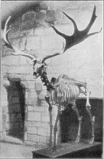
FIG. 3.-Skeleton of Irish Elk from Close-y-garey, St. John's.
From a photograph by Mr. G. B. Cowen.
These elk remains, where exact details of the sections or layers shown in the excavation are known, have always been obtained " from the lowermost portion of the alluvial deposits, and from beds which contain the first indications of organic life after the emergence of the land from under the ice-sheet," and Lamplugh suggests (Memoir, p. 388) that the elk was an early post-glacial inhabitant and may have reached this island, and even Ireland, across ice-fields when a remnant of the great glacier still occupied the basin of the Irish Sea; and may possibly never have been a permanent resident but only a migratory visitor. " The animal," he adds, " may have lingered on into the age of forests, when the principal peat-bogs of the Island were accumulated, but for this there is at present no positive evidence."
The depression of the land referred to above was followed again by a gradual elevation which Cumming supposes to have continued to the present day, but Lamplugh argues on the contrary that it has in its turn been followed by yet another slight depression. Traces of the last upheaval are marked all round the Island by a well-worn notch on the cliffs and by raised beaches at a height of 10 or 12 feet above present high-water mark. That these beaches, which are later than the forest period, were already formed, or being formed, while the Island was inhabited by Neolithic man, Lamplugh considers proved by his discovery of worked flints on their surfaces, " some struck into flakes on the spot." Dr. Munro has stated 10 that the upheaval which caused the similar 25 foot raised beaches in Scotland was completed about the beginning of the bronze age.
It was shown during the second quarter of the nineteenth century, mainly as a result of the labours of the Scandinavian archaeologists Thomsen, Nilssen and Worsaae, that a scientific division of prehistoric times in Northern Europe could be made into the three ages of " Stone," " Bronze " and " Iron." Further study of the earliest prehistoric remains, especially in France and England, has led to the recognition by archaeologists generally of an older and ruder as distinct from a later stone period, giving its in all the four divisions: - Palaeolithic, Neolithic, Bronze and Iron. These successive periods of advancing civilisation bridge the interval between geological and historic times, and a few sentences about the general characteristics of each age may be given before we pass to our notes on the Manks antiquities.
We may recall that at the close of the Tertiary Geological period, in Pleistocene times, Europe as far South as 50° north latitude was covered with a great ice-sheet largely consisting of glaciers which descended the valleys, crept down upon the plains, and even ground their way along the floor of the ocean. Scattered boulders, bed& of boulder clay and heaps and ridges of stone, gravel and sand (moraines) are found deposited in various parts of our country as remains of this " ice-age." Man was certainly in Europe and possibly even in Britain, which was then united to the Continent by continuous dry land, before the ice-age ; but no remains of that earliest inhabitant have yet been found in the Isle of Man. The so-called " River-drift " man has only left his remains in the South and South-east of England up to about a line drawn from the mouth of the Severn to the Wash, while the rather later " Cave " men extended further up to the North of Yorkshire. These were the men of the Palveo lithic Age, when the use of metals was not known and the stone implements were rude and unpolished. These primitive weapons, tools and other remains are found in association with the bones of long extinct animals charac teristic of the Pleistocene period, such as the mammoth, the cave bear and cave lion, the bison, a hyaena, and the woolly-haired rhinoceros. No traces of the presence of man at this early period or of any of such extinct mammals have, however, been found in our district.
As Great Britain became severed from the Continent before the next race of men, those of the Neolithic Age, spread over the country these must have arrived by sea; and as Man has been an island since even earlier times the successive waves of immigration which swept across from East to West must all have reached our shores by boat — unless, as Lomas has suggested, the sandy coast of North Lancashire may possibly have extended in prehistoric times by way of the Bahama banks to the Point of Ayre.
The Neolithic or later Stone Age man was of that non-Aryan pre-Celtic race which is usually called Ivernian or Iberian, and is supposed to be related to the Basques of the South of France and Spain. It is doubtful whether Palaeolithic man has left any descendants in our islands, but there is probably a considerable amount of Neolithic blood in the western parts of Britain. Man of the later Stone Age, when the next wave of immigration arrived, was no doubt driven back, but was probably assimilated rather than exterminated by the Celtic invaders from the East, who brought with them a knowledge of working in copper and inaugurated the age of bronze. The characteristic weapons and implements of the Neolithic Age are made of flint and other hard stone, usually finely chipped and ground at the edges, and some times polished with a beautiful finish. Most of the imple ments, however, were not polished, and the axe-heads are rarely perforated. The art of making pottery was known, spinning and weaving were practised, and all our common farm animals were domesticated.
Neolithic man in this country was small, averaging, it is calculated from the bones, about 5 feet in height, and had a long narrow (dolichocephalic) skull. The type is thought to be still recognisable amongst the smaller, dark Manks people; and the worship of "holy" wells, and the reverence for the tumulus and the standing stones may be regarded as a survival from these far back pre Aryan times.
There seems reason to believe that the use of copper spread in late Neolithic times from Cyprus along the shores of the Mediterranean to Western Europe; but the coming of copper and bronze to Britain is usually asso ciated with invasion of the country by an Aryan race, the Celts, who were taller than the Neolithic inhabitants, and had rounded (brachycephalic) skulls. The finest types of polished stone implements were made in this age along with the bronze weapons and tools that characterised it.
The Celtic tribes that invaded the West of Europe at the end of the later Stone Age have been divided into an earlier " Goidelic " (the Gaedhils of Ireland, Scotland and the Isle of Man) and a later " Brythonic " wave, separated possibly by centuries. The Goidels probably absorbed more of the blood of their non-Aryan predecessors and gave rise to those northerly and western Celtic nations that speak a Gaelic tongue; while the later Brythons became the more southerly peoples of Wales, Cornwall and Brittany. The Celtic element in the Isle of Man is Goidelic, and that with its Neolithic strain forms the basis of the Manks people, reinforced later on by a strong Scandinavian influence.
For the bearing of the local folklore upon prehistoric questions, the reader should refer to Mr. A. W. Moore's book, " Folklore of the Isle of Man " ; but we may briefly state here that the many stories of encounters between mortals and fairies or gnomes inhabiting the eaves or the earth between men with swords and demons with magic spells are supposed to be the relies of traditions handed down as to the real struggles between the invading Celts with bronze weapons and the pre-Aryan Neolithic inhabitants. There is some evidence, given by Moore and others, that the conquering Goidelic Celts were "impressed by the nature worship of their predecessors, and feared them as being gifted with magic powers." So, we are told, Mannanan Mac Lir, the rnon Aryan magician, " kept by necromancy the Land of Mann under mists"; and, when routed by St.Patrick, according to the Manks legends, he and his people being of small stature " became fairies and lived in the ancient tumuli, using flint arrow heads as the weapons with which they avenged their wrongs on human beings." 10
The fourth or Iron Age was a late Celtic period which extends into historic times. Just as stone weapons were still in common use during the Bronze Age, so we find the iron and bronze periods overlapping in their turn. These are facts of importance which must be borne in mind when discussing loose implements not associated with surroundings which clearly determine their period.
The majority of the prehistoric remains in the Isle of Man belong to the Neolithic and the Bronze periods, and it may well have been that in this remote and limited area these stages of civilisation may have each persisted on to later times than in other parts of Europe. It is impossible to assign dates for such " ages " in our district, but it may be of interest to note that the Neolithic period is said by Reinach to have extended at Crete from 4500 to 2800 B.C. It probably continued much later in our Western Isles. The knowledge of copper and bronze is supposed to have reached Crete about 2800 B.c., and in France Montelius estimates that the Bronze Age commenced in 2000 and ended about 850 B.C.
The earliest traces of man met with in our district show him to have been then in the Neolithic stage of civilisation.
Structural remains of the period are difficult to identify at first sight, and can only be determined with certainty- by careful excavation and examination. They consist of habitations, camps or forts, and burial places. We have also examples of " Neolithic floors or platforms," that is to say, areas of the ancient surface where flint implements of many kinds have been actually manufac tured. At the West Craig and the Lagagh in Andreas, at Case-ny-Hawin, near Ronaldsway, at Ballakaighan, German, and at Port St. Mary, have been found great accumulations of cores, chips, and worked flints of very primitive type.
On the brooghs overlooking Ramsey llooragh, building operations about 20 years ago disclosed an area, at a depth of from four to six feet below the surface, which was strewn with flint cores from which implements had been made, chips struck off in their fabrication, flakes, knives, scrapers 11 of at least three forms, drills or awls, arrow heads, and a few stone hammers, with great numbers of broken fragments 12 All the implements were small, for the most part very rudely formed, though some were rather more finely finished (see fig. 4).
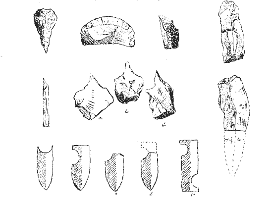
FIG. 4.-Types of Neolithic flint implements.
Three burial places were met with in this area, with fragments of decomposed bones in rude cists ; also broken pottery, ashes with traces of calcined and decomposed bone. Some of these remains may possibly have been of Bronze Age, the platform having been apparently occupied for a lengthy period. 13 No token of village life was discovered, and the place may have served only as a temporary camping ground from time to time.
A somewhat similar floor was discovered in 1899 by the Rev. J. Quine on the left bank of Glen Wyllin, Michael. Great numbers of flint implements have been found here-flakes, scrapers, awls, arrow tips; also hammer-stones showing signs of use, and differing some what in type from those at Ramsey. Though no hearth stones nor but foundations have been met with, the presence of " fire-holes " would- seem to show signs of habitation.
At Rhewyllin, Port St. Mary, Mr. F. Swinnerton discovered another Neolithic floor in 1900, with abundance of shells, decayed human bones, broken hammers, implements of quartz, flint, and slate; arrows, flakes, chips and scrapers. 14 At the base of the Alfred Pier, Port St. Mary, Mr. Swinnerton had previously found similar remains of a camping ground during the excavations made in forming the roadway. Here he met with decomposed human bones and teeth, bones of rabbit or hare; limpet, periwinkle and dog-whelk shells; a flint arrow-head, scrapers, flakes, and awls, besides some fragments of pottery which he took to be remains of cooking vessels. On this floor were several cists formed of large slabs set on edge, capped 'originally by a covering stone, typical examples of Neolithic burials (fig. 5).
Though the " floors " referred to show no traces of habitations, we have in places examples of " Hut-circles," or the foundations of primitive dwellings, similar to those met with elsewhere and identified as belonging to this period. A single one of them is clearly traceable in the middle of the high road at Ballaquane, near Dalby. The largest and most interesting collection of such remains is that around the Meayll Hill, near Port Erin, where there are three or four clusters all on a. level round the hill with the old village of Cregneash, which it is possible may have been another kept in continuous existence ever since Neolithic or Bronze times. These huts from their contents are evidently in association with the Meayll burial place, a curious circle of. cists placed higher up on the same hill, to be described further on. It must be noted, however, that the huts were apparently occupied up to a much later date than that of the stone circle, and, if Neolithic in origin, must belong to the close of that period, which doubtless persisted much later in the .Isle of Man than in Britain generally.
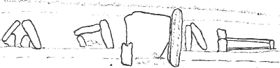
FIG. 5.-Neolithic cists, Port St. Mary. Sketch by F. Swinnerton.
Not far away, on the opposite mountain, at a hollow (known as the Sloc) in the Carnanes on the slope of Cronk-ny-Irree-Laa, is another collection of hut-circles, among which a few worked flints have been found.
In one or two places, as at the foot of Snaefell and at Ballakaighan, German, indications have been met with of pile-structures, reminding one of Boyd Dawkins' description of a log house in Ireland, surrounded by a staked enclosure. 15 At Ballakaighan these remains were found in association with a bog-oak canoe, hollowed out of a tree trunk; the space around being thickly strewn with rude flint implements, burnt stones, and ashes. (See figs. 7 and 8).
The earth and rubble foundations of numerous camps and small forts are met with around the coast, on craggy rocks in glens, and on hillsides, some of which date from this early period, though no doubt they inay have been occupied also much more recently. For example, a small peninsular earthwork at Gob-y-Garvane on the rocky Maughold coast; one on the broogh at Cass-ny-hawin, Santon ; Hango Broogh, on a rocky projection between St. Michael's isle and Langness, Malew ; and the two Boirranes near Dalby, are instances of coast defences which may have originated in Neolithic times. The earthwork within Peel Castle also, about which have been found many worked flints and a small stone axe, is likely to have been in use from the earliest times, but, neither in this nor the others is there any real indication of date, beyond the small size, the simple plan, and the presence in their immediate neighbourhood of worked flints. Inland, a good example may be seen on an isolated rock at Cashtal Ward, Tromode, and at Ballanicholas, Marown. On hill sides are remains at Ballakilpheric, Rushen, and one on the summit of the curious isolated hill at the entrance to Sulby Glen known as Knock-Sumark.
1 The Geology of the Isle of Man, by G. W. Lamplugh : Memoirs of the Geological Survey, 1903.
2 See Map, fig. 1, on back of title-page.
3 The Isle of Man, by J. G. Cumming (1848), p. 216, footnote.
4 Yn Lioar Manninagh, Vol. I., p. 56.
5 On the other hand, Lomas (Proc. Liverpool Geol. Soc., 1903-4) believes that on the melting of the Irish Sea glacier a low undulating land connection existed between the Island and Lancashire ; and that following the advance of vegetation the Irish Elk may have crossed by means of this lost land.
6 Arch. Camb. XL, 3rd Series, p. 429.
7 See Boyd Dawkins' Early Man in Britain, p. 247, and 257.
8 British Assoc. Report for 1898 (Bristol) pp. 548-551.
9 Proc. Roy. Soc. Edinb., Vol. XXV., p. 272.
10 Moore, History of the Isle of Man, p. 43,
11 In regard to the separation of stone implements into axes, celts, lances, knives, scrapers, awls, &c., it is important to note that Dr. W. E. Roth, writing on the Ethnography of Queensland, says that the modern savage certainly does not recognise these fine distinctions.
In the case of the earlier and ruder forms at least it may well have been that the shape of the detached or chosen fragment was more or less accidental, and it was probably used indifferently for various purposes as was found convenient.
12 Yn Lioar Manninagh, 1., 2, 90, 131, 212.
13 Yn Lioar Manninagh, I., 2, 262.
14 Yn Lioar Manninagh, III., 635.
15 See Early Man in Britain, p. 288.
|
|
|
|
|
|
||
|
Any comments, errors or omissions
gratefully received The
Editor |
||