[From Land of Britain, part 44, 1941]
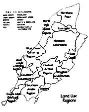
V. LAND USE REGIONS
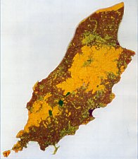
Dark Green - Woodland
Light Green - Permanent Grass
Brown - Arable
Yellow -Heath + Moorland
Purple - Gardens
Red - Agriculturally Unproductive |
Note this was an overlay to the map
The colour printing of the Map was not of today's high standard |
Region 1. The Northern Plain
This region lies to the east of the Lhen and to the north of the Curraghs and includes the parishes of Andreas, Bride and
part of Lezayre. The statistics published by the Manx Board of Agriculture show that Andreas is by far the most important
parish for sheep and at the same time is one of the important beef poducing areas. Bride is the first parish in the island
for beef cattle and Lezayre is well up the list of both sheep and cattle producers. Andreas and Lezayre both have important
herds of dairy cattle to supply milk for the villages of the plain and in particular for Ramsey. Bride on the other hand
has the least number of dairy cattle of any parish and is pre-eminently concerned with the fattening of cattle for beef.
The northern plain is the cattle feeding area of the island par excellence and is the most important producer of fat lamb.
Ramsey is the agricultural centre of the island and here every week is held the biggest livestock market. It is a significant
reflection of the physical environment that such wheat as is grown in the island is confined to this northern area of drier
climatic conditions and sandy soils ; moreover the warmer sandy soils together with the shelter from the south-westerly
winds afforded the northern plain by the Manx mountains result in harvests being a fortnight earlier here than elsewhere
in the island.
Region 2. The Curraghs
The Curraghs are areas of recent drainage and settlement but the settlement is thin and
markedly concentrated on higher, drier patches. Farms on the northern plain have traditional
right of pasture in the Curraghs which by long usage goes with the farm but they are damp
pastures and provide grazing usually in the summer only. While representing a distinct unit
the Curraghs are a negative area so far as land use is concerned.
Region 3. The North-west Mixed Farming Region
The region extends from the Lhen in the north to the limit of the glacial soils and gravels in the south near Glen Mooar.
The parishes included are Jurby, Ballaugh and Michael ; these have not specialised to the same extent as the northern plain
and dairy cattle, beef cattle and sheep are all well represented but with dairy cattle rather more numerous than beef cattle
and both less important than sheep.
Region 4. West Coast Dairying Region
From Glen Mooar south to Peel and inland into the middle of the central valley, including
the parishes of Patrick and German, is a region in which dairying is of prime importance in
farm management and this is largely a reflection of the nearness of the Peel market for milk.
Sheep are also very important.
Region 5. West and South-west Coast Crofting Region
In the south-west of the island the uplands diminish and become broken up. Here fishing has played a considerable part
in the economy especially in the parishes of Patrick, Rushen and to some extent Arbory where it centred on Port St. Mary,
Port Erin and Peel. The men employed in the fishing were often also small farmers doing the farm work from September to
July but leaving the women to look after the farm during their absence on the summer fishing. These fisher-farmers often
took small crofts on the high land which they manured with seaweed for the year's crop of potatoes. In such cases no rent
was paid, the owners considering the manuring for the succeeding year's crop as an equivalent for the use of the ground.
Although fishing was often the necessary complement of agriculture others supplemented agriculture on their poorer lands
by working in the silver mines of Foxdale. Towards the end of the nineteenth century the supplementary occupations of fishing
and mining fell into decay. This carried grave results for the crofters especially because the crofts and farms were situated
on the edge of the waste and they then ceased to be an economic proposition. Rural depopulation followed and the land abandoned
by the crofters was absorbed into larger farms. As a result of this process of consolidation, holdings today tend to be
larger than was the case a century ago. Little agriculture is possible away from the small stretches of coastal plateau
included within the region and this region is of less significance in the life of the island than any other.
Region 6. East Coast Region
This area in the parishes of Maughold and Lonan is generally poorer than the other parts of the arable fringe of the island.
Of all the regions it is the least specialised, having its interests fairly evenly divided between beef cattle, dairy cattle
and sheep. The poorer quality of the farming here is to be attributed directly to the poorness of the topography and soil
cover, but within this region one area of good arable land is to be noted-that round Maughold Head which takes advantage
of a fairly level extent of low land. There are some similarities between the east coast region and the crofting area of
the south-west. Mining in the Laxey Valley was at its height in 1894 but by 1912 the mines had ceased to be a paying proposition.
The decline of mining here was followed by consequences similar to those which came to the west coast with the decline of
fishing for many of the miners were also crofters and small farmers. Their settlement was of the squatter type on the edge
of the waste and with the decay of mining these also ceased to be a paying proposition and many of the small-holdings were
absorbed into larger farms and derelict cottages are widespread around Laxey valley.
Region 7. The Central Arable Region
Occupying the eastern half of the central valley and the slopes leading to it from the north and south, this is the most
important dairying district in the island; beef cattle are less important and sheep are found in any number only in Braddan
parish, a fact which reflects the extension of Braddan on to the mountains. The parishes of Marown and Santon are primarily
interested in dairy cattle rearing and the supplying of milk and market produce to Douglas.
Region 8. Douglas and Onchan
This region is the tourist centre of the island. The outskirts have some dairy farming and a relatively large number of
sheep. Market gardening is carried on for the local markets, especially behind Douglas.
Region 9. Santon Pasture Region
The permanent pasture of the parish of Santon is devoted mostly to dairy cattle but as is generally the case beef cattle
and sheep are not of negligible, although of secondary, importance
Region 10. The Southern Arable Region
Centring on the plain of Malew this region leads the island in livestock ; it is the most
important dairying region and although many cattle are sent to the north of the island for fattening
it is still the second district of the island for beef cattle and for sheep. Moreover it is the richest
agricultural region and barley and wheat are to be found here but nowhere else in the island
apart from some wheat on the northern plain. It is the historical arable area and features not
to be found elsewhere are the well-built stone walls, the large well-drained fields and the existence
of the manor and the farm house near by, a feature which had its origin in the large estates
that formerly existed here.
Market gardening is carried on to supply local markets but although the Manx market gardener has a great opportunity in
the half-million holiday visitors to the island and fruits and vegetables are consumed in large quantities from May to September,
this side of catering for the tourist industry has not developed because the climate of the island is such that a number
of fruit and salad crops (such as tomatoes and cucumber) must be grown under glass. Some soft fruits such as black currants,
red currants, gooseberries and raspberries find the outdoor climate most suitable ; excellent strawberries are grown under
the protection of high garden walls and may be said to be the main garden crop of the island. For market gardening the island
has the advantages of a high average number of hours of bright sunshine and the light factor is of vital importance ; moreover
only 40 to 50 days on the average record frost and there is little hail or snow. Strong winds of gale force, however, are
frequent and wet days are numerous and these can have serious effect on the crops.
Region 11. Northern Mountains and Southern Mountains
The rough grazing is utilised for the rearing of wool sheep and conditions and utilisation are essentially the same on
both areas.