Figure 110 - Diagrammic plan and section of Foxdale Lode
[from Lamplugh, Geology of IoM, 1903]
From both the geological and economic points of view the Foxdale Mines stand pre-eminent in the Isle of Man ; during the latter half of the past Century they have indeed attained to the first rank among the lead-mines of the United Kingdom for productiveness, as well as for good management, Which has enabled them to survive successfully the vicissitudes in the market value of their product that have extinguished the industry in many mining districts. They are situated in the interior of the southern part of the Island, close to the head-waters of the Foxdale River. The east-and-west lode which they explore traverses the northern slopes of South Barrule and Granite Mountain (formerly known as Slieau ny Clough), the present workings being confined to the portion intersecting the village of Foxdale, at an elevation of from 400 to 450 feet above sea-level.
The date of the first discovery of ore in this locality is not known, but was at any rate before the early part of the 18th century, as in a report made to Lord Derby in 1721 the governor of the Island mentions that " Foxdayle hath from the first been worked with the least success . . . . I shall be forced to give it up, for the longer we work it the worser it grows." 1
Since the surrounding ground is more or less drift-covered, we may presume that the lode was first recognised in the bed of the Foxdale River, which crosses its richest portion. Old workings may still be traced in the vicinity of the stream ; and it was probably these to which Feltham referred in 1798 as having produced rich and abundant ore,2 and which Woods noticed early in the next century, in a deserted condition, "the rubbish from the shafts consisting almost wholly of fragments of slate, mixed with pieces of brown blende, a little lead glance and some sparry iron ore." (" Account of . . . the Isle of Man," 1811, p. 12.) Berger also found the mines inactive (in 1811 ?) ; he mentions that a " small-grained granite" had been found in one of the shafts, and that a productive north and south cross-vein (see p. 510) had been discovered, with richer ore at its junction with the main vein. He was informed that the granite was found in a shaft 40 yards deep, where it "formed the north side of the vein, the galena adhering to it, while the south side was a stratified rock." Macculloch, a few years later, likewise found the workings deserted and inaccessible.4
Some information regarding these old workings has been obtained from documents preserved in the Office of Woods and Forests. In a schedule of the property purchased by the Crown from the Duke of Athol in 1827-1828, we find under the heading of Lead-mines "New Foxdale," " Old Foxdale," and " Flappy Vein " (the cross-course mentioned by Berger), given as three distinct mines; and it is mentioned that these are subject to a lease granted by the Duke to Michael Knott for a term of 31 years from November, 1823. There is also in the same office an old plan and section prepared by J. A. Twigg in 1826, the former lettered, "Section of the vein of lead-ore at the New Foxdale Mine, wrought by M. Knott, Esq., in the Isle of Man, showing the course of the levels (driven near the vein) and a view of the shafts at present sunk, and also some trials made upon the Head of the vein at the Surface." This plan shows the Engine Shaft to be 38 fathoms deep, with two levels west and five levels east from it; the longest level was that at 15 fathoms,which went 160 fathoms east and was reached by three air-shafts E. of Engine Shaft and by one W. of it ; and still farther E. were two more sinkings, to a depth of 15 fathoms, with short drivings. The ground-plan indicates the main lode, with a " south string" and " north string " [? Magee’s Lode, see p. 510], just east of Engine Shaft : and a " strong vein " [? = Flappy Vein] going off nearly N.—S. on the west of Engine Shaft ; and also an E.—W. vein joining the " main vein " 33 fathoms west of that shaft, on which is the note " This vein contains manganese and other minerals not congenial to lead." It shows, moreover, the position of " shaft sunk by the old men," and " old workings wrought,+ 40 years ago."
Soon after Mr. Knott obtained his lease he appears to have sold his interest to a company, who took up the working ; and thenceforward, on one part or another of the vein, mining has gone on continuously up to the present day. The following account of the progress of the mine up to 1848 is given by Cumming
"The chief workings at that time [i.e., circa 1823] were upon what is generally termed the Foxdale vein, to the northward of the great granitic boss, crossed by veins striking out from the nucleus of the granite. Very little except horse and water power had been employed, though there were at that time two small steam-engines also at work, and the depth reached was never more than 40 fathoms. The great workings are now carried on [circa 1848] at the eastern and western extremities of the district, at Cornelly or Jones vein [see p. 516] in the neighbourhood of Kenna, and at the Beckwith vein in Glen Rushen. The Cronck Vane 1 mine, more in the centre of the district, on the brow of the hill betwixt Sleauwhallin and South Barrule, a few years ago was worked with very great results. The miners appear to have fallen in with one of those great sops or masses of ore which I have noticed in the body of this work as generally characteristic of limestone districts, but which appears as a peculiar feature of this seliistose country also."
"At the time of my visit, in company with Professor Aimsted, three years ago, the depth attained into the body of ore was 88 fathoms, the width of the vein or mass at its centre being 24 feet, thinning off to the E. and W. to about 4 feet. The length of this body of productive ore was 14 fathoms. The vein had generally a southerly dip, the walls being very clean, and presenting in several places extensive appearances of slickenside. There is very little gossan upon these veins, and not in general any indication of their presence till the workman comes directly upon the body of lead. The prediction of Professor Ansted at that time, respecting the duration of the working at the Cronck Vane Mine, seems to have been fully verified, as I found on my last visit to the place the works abandoned."
"The number of men and boys employed at the mines of this company in different parts of the district is generally about 350, and the average raising of ore for the last ten years has been about 2,400 tons per annum. The product gives about 70 per cent. for lead and 9 ozs. silver per ton." 2
Since the above was written, the operations on the eastern and western extremities of the Foxdale lode and on the Cornelly (afterwards known as Townsend) vein have gradually been suspended; and for many years past, work has been confined to deep mining on the site of the earliest workings close to Foxdale village. An admirable record of the later history of the mines of the district is contained in the series of reports made annually between the years 1857 and 1888 by Mr. (Sir) W. W. Smyth, as the result of his personal examination; these are preserved in manuscript at the London Office of Woods and Forests, and in the context will be largely drawn upon for information respecting workings which are now inaccessible.
In 1867, D. Forbes in describing3 the occurrence of Polytelite (Silber fahlerz) from the Foxdale mines, gave a short account of the character of the lode. He stated, on the authority of Mr. J. L. Thomas, that the polytelite occurred in the most easterly workings of the mine where the lode ran out of slate into granite, the minerals associated with it being galena, chalcopyrite, iron-pyrites, zinc-blende, quartz, dolomite, chalybite and calcite. Mr. Forbes gave an analysis of the polytelite, showing it to contain 1.357 per cent. of silver. His remarks on the granite and on the reported occurrence of gold in the locality will be alluded to on a subsequent page (p. 549).
In 1880 Mr. (Sir) W. W. Smyth gave an account of the general features of the lode in a paper " On the occurrence of Feather Ore (Plumosite) in Foxdale". The following passages are quoted from this paper as supplying an excellent and authoritative description of the vein and its rare mineral, plumosite
"The masterly lode of Foxdale has been worked for some four miles, not quite continuously, from its east and west course, and to an extreme depth nearly approaching 200 fathoms" [since carried to 290 fathoms, see seq.]. "It varies in character, and often within short distances, to as great aim extent as perhaps any lode that could be cited; sometimes, as at Beckwiths, a body of more or less orey material of 5 or 6 fathoms in width, in other parts exhibiting powerful ribs of solid galena with several tons of ore to the running fathom, again parting into parallel branches of an ordinary lead ore on the south wall and others of a highly argentiferous variety affecting the north side, and often with from 2 to 6 fathoms of lode material between them. Between the courses and shoots of ore is encountered (and sometimes unfortunately for very long distances) a quantity of unproductive ground in which detrital killas, or granite, and ribs of chalybite (carbonate of iron), and singular veins and seams of aim indurated black clay, form the chief constituents. This latter material, cutting sharply against some of the other lighter coloured substances, gives rise to appearances very instructive as regards successive openings and fillings of parts of the lode, and reminds one of the so-called glauch, which plays a similar part in the small but rich veins of tellurium and gold at Nagyag in Transylvania."
"Furthermore, the variation in appearance is added to by the fact that whilst the country rock has mostly been killas, the Old Foxdale Mine encountered granite at a medium depth—In some places only on one wall, and is now opening in many successive levels in a solid mass of that rock. No sudden alteration has been produced by the change of ‘country’; but fluor spar is abundant in some of the western drivings, and in the deeper levels the main or south part of the lode appears to be more frequently than elsewhere a matrix of grey quartz. In these deeper levels a new and unusual feature has been the emanation of a gas, probably carbonic acid, from the crevices of the south wall of the lode, which has the effect of instantly quenching the flame of the candle, and at times had interfered with the work for days together."
"The chief engine shaft is Bawdens, and to the west of this, 10 to 20 fathoms, about the 100-fathom level, in a series of ‘pitches’ extending up to the 86, soon above which the killas comes in as ‘country,’ is the part of the mine in which the Plumosite has been found. Its habitat appears to be on the north side of the south part of the great lode. In other portions of the mine, about the ‘old shaft’ further east than the above, the well known antimonial ore of copper, called fahlerz or tetrahedrite, has been met with in spots and branches, notably at the 100 and 115-fathom levels; and the frequent tendency of this mineral to contain a large percentage of silver has no doubt had something to do with the unusual value for silver of the galena of some of the northern parts of the lode. These have in fact assayed at times from 100 to above 200 oz. of silver to the ton of lead, and have thus in many places admitted of being worked in thin strings, and in hard ground, where common lead-ore would not have paid to work. It might have been expected that the two antimonial minerals, the fahlerz and the plumosite, would stand in some relation to each other. It is true they both occur at nearly the same level ; but where the latter has been found there is no trace of the former."
" The plumosite is associated with a fine-grained galena, and a vuggy or cellular quartz, with many transparent crystals ; it occupies these vugs, seldom filling them up entirely, but usually attached by one portion, whilst the remainder floats loosely. Its appearance is much like that of a piece of dark cotton wool, sometimes like a little wreath of smoke A closer examination will reveal multitudes of the finest spiculae, bright grey metallic-lustred hairs confusedly flung together, and sometimes so felted into one plane, the prisms crossing in different directions, as to look like a bit of rag or woven cloth. The colour, however, is always grey, and hence differs at once from the Zundererz or Tinder ore of the German mines, in which a notable proportion of silver, about 2.56 per cent., is revealed by the reddish colour due to an admixture of the mineral, Ruby silver ore. One or two of the specimens had a slight touch of that dull red colour which characterises the Zundererz; but in view of the minute quantity of the mineral it is difficult to decide whether the redness may be due to one of the ‘ruby silvers’ or to kermesite."
"Under the microscope the prisms come out distinctly; but it is difficult to be satisfied about their terminal faces. Other very curious features are now discernible; the hairlike prisms often affect curvilinear forms ; arcs of circles and parabolas are not infrequent, and in some cases a coil of the microscopic hairs forms a perfect ring of very uniform thickness. The long crystals are flexible and elastic, and those which are anchored at one end will be seen to wave to and fro in a current of air. Some of these are adorned with minute bright crystals set at intervals upon them like beads upon a string. These latter appear to be cubical, and may probably be pyrites I cannot but regard it as a singular circumstance, under the data which we at present possess, that this new occurrence of plumosite should be connected exclusively with galena, quartz, and their usual associates The plumosite is, in point of date of deposition, the last mineral which has been formed in the little caverns of the lode, and its delicate fibres and webs seem to indicate, whatever process we may, call in to explain their origin, a period of quiet and undisturbed action.’
The emanation of carbonic acid gas from the lode, referred to by Smyth in the above account, was more fully described by Dr. C. Le Neve Foster in 1883,2 who noticed the phenomenon in a cross-cut in granite, 14 fathoms south, from the 185 fathom level of the mine. Dr. Foster mentions in this paper that there had been a similar issue for a fortnight from a vug in the sole of the 80 fathom level of the Townshend (Cornelly) Mine three years previously, and that small escapes of the same gas had been reported from ‘lochs’in the Great Laxey Mine.
The further literature relating to the Foxdale mines includes a short general description of the lode in 1890 by Prof. W. Boyd Dawkins 3; and the brief accounts to be found in most of the larger British text-books on Ore-deposits; e.g., J. A. Phillips’ "Treatise on Ore Deposits," pp. 304-6 (2nd ed., London, 1896); C. Le Neve Foster’s "Text-book of Ore and Stone Mining," pp. 335-8 (Lond., 1894).
While this memoir was in the press a short note on the mines by Capt. W. H. Kitto of Foxdale, read in 1892 before the Isle of Man Nat. Hist. and Antiq. Society, has been published (Yn Lioar Manninagh, vol. ii., 1901, p. 32). The following is Capt. Kitto’s description of the lodes:—" There are several lodes in Old Foxdale, but the two principal bearing ones called the North and South, are very dissimilar—the former hard, with all its ore highly charged with silver, ranging from 50 to 400 ounces per ton, and at times having small quantities of Tetrahedrite or Fahlerz, an ore of copper and antimony averaging from 3,000 to 4,000 ounces of silver, whilst the South, or soft doukey lode, by its side yields comparatively little silver, but a greater quantity of lead ore."
With regard to the occurrence of Plumosite in the mine, Capt. Kitto gives the, following additional information:—" Plumosite was first discovered in the western part of these mines at the 86 fathom level. It is associated with fine-grained galena, and a vuggy quartz, with transparent crystals; Recently we have discovered it in the eastern part of the mine, about 60 fathoms deeper, in grey quartz and killas, with both sides of the lode composed of granite. We have not found it in large quantities, and never entirely in granite, but always in the locality of lead rich in silver." (Op. cit. p. 33.)
The annual output of ore from the mines since 1845 has been published in "Mineral Statistics" and other official records, and from these sources the Table given on p. 512 has been compiled. The periodical reports of the managers of the mines, giving full details of the progress of the workings, have for some years past been reproduced in extenso in the local weekly newspapers published in Douglas. Files of these newspapers may be consulted in the Douglas Free Library.
1 Knowsley (Loose) Papers quoted by A. WT.
Moore in "History of the Isle of Man," vol. ii. p. 964.
2 "Tour through the Isle of Man," p. 213.
3 Trans. Geol. Soc., vol. ii. (1814), p. 37 and p. 52.
4 "Western Isles," vol. ii., p. 577 (1819).
1 This refers to Cross’s Mine (Cross Vein of 6-inch Ordnance
Map, Bk. 12), ½ mile west of Doarlish Head.
2 "Isle of Man " p. 309.
~ "Researches in British Mineralogy," Phil. Mag., 4th ser., vol.
xxxiv pp. 350-4.
1 Trans. Roy. Geol. Soc. of Cornwall, vol. x., pp. 82-89.
1 Italics not in the original.
2 Trans. Roy. Geol. Soc. of Cornwall, vol. x., pp. 175-6.
2 On the clay slates and phyllites of the South of the Isle of Man, and a section of the Foxdale Mine." Trans. Manch. Geol. Soc., vol. xx., pp. 53-56.
The main Foxdale lode has been worked almost continuously, by a string of shafts extending from Glen Rushen on the west to a little to the eastward of Foxdale village on the east, a distance of about 2½ miles, with outworkings, on a supposed prolongation of one of its branches at Eairy ½ mile still farther eastward. Its leading characteristics have been given in he preceding general description and in the passages quoted from Sir W. W. Smyth’s account of the mines. It has a persistent southerly underlie, and in the central portion of its course, where best defined, strikes in an average direction of E. 3°-5° N. to W. a~—5° S. Both eastward and westward it splits into branches, and is lost in confused and broken ground. in spite of repeated searches (some account of which is given on pp. 546 and 548) it has not been traced west of the stream in Glen Rushen, and the most westerly working to yield a profitable quantity of ore is the Beckwith Mine, 400 yards east of that stream, at an altitude of about 650 feet above ordnance datum.
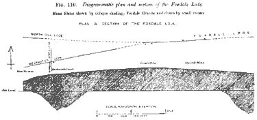
The diagram overleaf based on the plans in the possession of the Isle of Man (Foxdale) Mining company, will serve to show the position and depth of the shafts on the main lode, and the lie of its principal branches and cross-courses
Figure 110 - Diagrammic plan and section of Foxdale Lode
![Figure 110[a] - click for larger image](zfig110a.gif)
Figure 110[a] - continuation of figure 110
The following account of the discovery of the riches of this temporarily productive porlion of the vein was given by the late Mr. W. Beckwith under the date April 9th, 1881, and printed in the prospectus of the "New Foxdale Mining Syndicate" (Garth Trial, see p. 515) :— "The Beckwith vein was discovered by the driver of a hay-cart crossing the west side of South Barrule, who found a solid lump of lead-ore in the wheel-track; this induced me to make a search in the neighbourhood, when I discovered ore among the roots of the heather, and immediately put two men to work who, on the following day opened up the ore, and about 650 tons were raised before sinking was commenced. The ultimate result of this discovery was about 50,000 tons of lead-ore which realised about three quarters of a million sterling." . . . . "Like all veins in the Isle of Man this enormous yield was irregular in its deposit, from the surface down to the 70-fathom level the vein averaging from 10 to 15 feet wide and producing fully 15 tons of lead-ore to the fathom. in the next 20 fathoms the vein grew poor, but on persevering with the sinking the ore was again cut into at the 90-fathom level, this new deposit being more productive than before, in places fully 26 feet wide and yielding 30 tons ore to the fathom. This great productiveness continued for another 50 fathoms down when the mine again became poor, evidently from the same causes that existed in the levels above."
In spite of its magnificent commencement, the deeper part of the mine and the lateral workings proved entirely unprofitable and it was abandoned about 1866, though an attempt was made 15 or 20 years later to form a company to restart it. The main or ‘ Beckwith’s ‘ shaft attained a depth of about 185 fathoms from the surface, intercepting the ‘ old day-level’ at 15 fathoms and the ‘ new day-level ‘ at about 35 fathoms, with levels at 15, 30, 45, 60, 75, 90, 102, 117, 132, and 147 fathoms below the new day-level. The ore-body seems to have been very limited in lateral extent throughout, lying chiefly to the eastward of the main shaft, having a general trend westward, and disappearing in depth below the 102 fathom level. The vein appears to be a southerly branch of the Foxdale Lode, and strikes S. 10° W., with a southerly underlie. A supposed north branch, 200 to 300 yards north of Beckwith’s, striking approximately E.—W., has been recognised by the miners as the ‘North Gill Lode,’ and tested in several places, but without profitable result. These converging branches are supposed to fall together in the vicinity of Cross’s Mine (see below) Besides these E.—W. veins, a productive cross-course striking nearly north and south (N. 3° W.), named ‘Wardell’s North Lode,’ occurs at the Beckwith Mine, and was worked by N.—S. levels from that shaft, yielding ore chiefly between the 60 and 90 fathom levels, in view of the importance of determining the relative ages of these veins, I made special inquiry as to their intersection, and was informed by Captain J. Kitto that the N.—S. (Wardell’s) lode was found to he shifted about 3 fathoms eastward on the south side by the E.—W. (Beckwith’s) lode. Their relations are thus the same here as in the Laxey, Snaefell, and Ballacorkish mines where the N.—S. veins are displaced by later E.—W. ‘slides’ or faults ; with this difference, however, that whereas the ‘slides’ of those mines are almost invariably barren, in this case the E.—W. vein constitutes the most productive part of the mine.
The ‘country’ rock of the mimic is a highly sheared sericitic striped slate, which merges westward into the dark blue homogeneous ‘Barrule Slate’ (p. 53) of Dalby Mountain, and eastward into a belt of alternately slaty and gritty flags. The prevalent dip of these rocks is at a high angle towards N.N.W., but in the vicinity of the lode and between its two branches north-north-easterly dips occur in several Places. In the spoil-heap were noticed fragments of one of the common basic (‘older green-stone’) dykes crushed into a schist, but no trace of the Foxdale granite or its elvans exists in this locality. The ground around the mine is more or less drift-covered (p. 458), and it is only in the glens that the rocks are well exposed.
During the later stages of its activity the Beckwith mine was annually examined by Sir W. W. Smyth, and as it has now fallen to ruin and its workings are quite inaccessible, a few notes drawn from the MSS. reports of this authority may prove useful.
In the report for 1857 it is mentioned that down to below 90 fathoms the mine had been marvelously rich, but that the lower levels, at 117, 132, and 147 fathoms, had been driven on a lode showing hardly any trace of ore; and that a great drawback was found in the enormous amount of timber required and its rapid destruction by dry rot as well as by the heavy pressure of the strata. The N. and S. cross-vein had been opened to 160 fathoms S. of the shaft in the 75 fathom level, and a course of ore got in the same vein in the 60 fathom level N. In 1858 reference is made to a trial known as WEST BECKWITH’S at the western part of the Foxdale sett, where a shaft had been sunk 13 fathoms on a large lode filled with black clay-slate, but without ore. In 1859 it is noted that in the principal mine the total poverty of the lower levels had been a little relieved by some small sprigs of galena at the 132 level in the west cross-cut, and that the 117 level had some very good ore on the N. part of the lode. On the " Wardell’s " cross-course the 75 level was out 200 fathoms S., while the 60 and 75 N., both poor at the end, had passed through " a long run of tolerably good ground which will yield material for stoping." At WEST BECKWITHs a level had been driven E. for 50 fathoms " in black shale with a little quartz," and doubt was expressed whether it was in the lode at all. In 1862 it is stated that "great lengths of gallery have been opened beneath the formerly rich parts of the lode without finding any noticeable ore" ; and detailed accounts of the 117, 132 and 145 fathom levels are given, showing a total length of unproductive driving of "about 317 fathoms." The reports for the ensuing years record the gradual cessation of all work except that of driving the adit eastward, according to covenant, to connect with Cross’s Mine, 1,200 yards E. of Beckwith’s. In 1877 the inspection of this adit is described ; it was reached by descending the main shaft to 40 fathoms. and followed for 345 fathoms, to the end, which was in very confused ground "where the two lodes, the main one and the North Gill are closing together" ; it was now within 50 fathoms of the old workings at Cross’s Mine, and was barren of ore, nor was any seen in the numerous cross-cuts. This level is also referred to in the two following years, after which the mine is not again mentioned.
This mine, the position of which has just been indicated, lies at aim elevation of above 830 feet above O.D. This is evidently the ‘Cronck Vamie mine’ described by Cumming in the passage above quoted (p. 501). Its history appears to have been a repetition of that of Beckwith’s Mine on a smaller scale— a good but limited ore-body having been met with iii the upper workings ; and poverty below. It does not seem to have been worked since its abandonment at the date noted by Cumming. The mine consisted of two shafts 80 yards apart, viz., ‘Engine Shaft’ on the west and ‘Whim Shaft’ on the east; with levels at 20, 30, 40, 50, (15 and 80 fathoms. The ore-body described by Cumming lay mainly between the two shafts, and was lost below the 65 fathom level, and also in the drivings east and west of the mine. The longest or pioneer levels were the 80 fathoms, which went 79 fathoms west from ‘Engine Shaft, and the 50 fathoms, which was driven 95 fathoms east of ‘Whim Shaft’ and ended in barren ground about 50 fathoms short of the most westerly driving from Dixon’s Mine.’
This mine, lying to the east of Cross’s at a distance of only 400 or 500 yards, was worked by two shafts 280 yards apart, with levels at 17, 32, and 47 fathoms in the ‘Engine (western) Shaft,’ and at 17 fathoms in the ‘East Shaft.’2 The daylevel was reached by a cross-cut from the little valley north of the mine. As in the mine last described, the workings were wholly in slate; very little ore appears to have been found. Smyth mentions it in his report for 1857 as having been sunk to the 47 fathom level, but with nothing of promise in sight; and in the following year describes it as a "great disappointment," some productive ribs at the 17 fathom level having gone out in the 32, and on the south side there was similar deterioration below the adit level. In 1865 we learn on the same authority that after being for many years abandoned a shaft and adit were reopened. In 1867 the adit had been cleared for no less than 200 fathoms, and the 17 fathom level opened, with a little lead westward, but on the east for scores of fathoms without showing a speck of ore; from the 34 fathom level a cross-cut had been driven out in which it was difficult to recognise the limits of the lode ; and only a few toms of ore in all had been raised from this new undertaking. In 1868 it is noted that only a cross-cut at the 44 level was driving ; and this is the last mention of the mine in the reports.
1 Information from mining plans in the office of
the Foxdale Company.
2 Ibid.
In following the lode eastward from Dixon’s we descend into the Foxdale valley by a steep slope on which there have been a few shallow unproductive trials in the slates. The Foxdale Mines, from which by far the greater proportion of the mineral produce of the lode has been obtained, lie at the foot of this slope at altitudes of between 400 and 450 feet above sea-level. The principal shafts now in operation are—Bawden’s the most westerly, with the bottom level at 260 fathoms ; Beckwith’s, with the bottom at 290 fathoms’; and Potts, the most easterly, with the bottom at 200 fathoms. The distance in a straight line between the first and last mentioned is 750 yards, and the extreme length of the underground workings from end to end in 1897, was 1,510 yards; the pioneer level westward being the 170 fathoms, which went 320 fathoms west of Bawden’s and approached within about 175 fathoms of the overhead position of the east shaft at Dixon’s Mine; and the pioneer east, the 127 level, going 435 fathoms east of Bawden’s. The above-mentioned shafts are sunk vertically on the southern side of the outcrop of the lode, and intercept it on the underlie. They commence in slate, but pass, at varying depths, into granite, as shown in the section (Fig. 110, p. 507), their lower workings being entirely in the igneous rock.
In the higher part of the mine the slate is traversed by elvans springing from the granite, which render the shelving upper surface of the intrusion ragged and uneven, just as it is seen to be at its outcrop on the hill-top south of the mines. Unfortunately the old upper levels which traversed the junction of the intrusive rock with the slate are now mostly inaccessible, and it is only at a few points that the contact can be studied. A few details respecting them may be gleaned, however, from Smyth’s reports, quoted in the context. The junction was seen by the writer in 1896, in a cross-cut in the 115 fathom level, at the eastern end of the mine, and there showed distinct evidence of faulting, the granite being separated from the slate by a ‘dowky’ slightly shickemisided vein aim inch or two wide; but the vertical displacement did not appear to be great. As previously mentioned the lode, of which this vein seemed to form one of the ‘branches,’ is rarely a simple fissure but a belt of disturbed ‘country,’ with more or less parallel fractures showing nearly horizontal shickensides and containing brecciated rock, with vein-stuff and ore generally in ribs but occasionally also brecciated. The granite included in and adjacent to the lode has undergone partial decomposition, and it softens and ‘bursts’ on exposure to air in the workings; while the same rock exposed in cross-cuts outside the lode remains solid and very little altered. The rock thus affected is rendered somewhat ‘platy’ by numerous joints parallel to the vein, some of which exhibit traces of movement; and the miners appear to regard all material of this character as part of the ‘lode,’ ribs of ore being likely to occur anywhere within it. The ‘bursting’ of the rock-faces in the workings is probably due to the felspars having been decomposed while under restraint, rapid expansion taking place as soon as relief is obtained.
The ore-bodies have a general trend downward towards the west. The chief minerals associated with the galena in the vein-stuff have been enumerated in the passages already quoted. The western portion of the mines is on the whole characterised by the presence of large bodies of coarsely crystalline galena poor in silver; and the eastern, by smaller quantities of fine-grained ore rich in silver. With regard to the occasional presence of the rarer minerals, silberfahlerz and plumosite, we learn from Sir W. W. Smyth’s and Capt. Kitto’s notes that these minerals are limited to that part of the vein which lies in the vicinity of the junction of the slate with the granite.
The seam of "indurated black clay" mentioned by Sir W. W. Smyth as a peculiar feature of the lode is rarely absent, serving the miners as an indicator where the vein is pinched or unproductive. It varies from a mere film to a thickness of 2 or 3 inches, and widens out into a ‘dowky’ mass in the vicinity of the ore-bodies ; and in such places is reported sometimes itself to contain ‘stones’ of ore. It has probably been brought down by percolating waters from the overlying slate during one of the later expansion-movements along the fissure, perhaps at the same time as the detritus observed by Smyth in the 170-fathom level east, which exhibited "the peculiarity of fragments of killas or clay-slate in the breccia [of the lode], unexpected so deep in the granite." (MSS. Report for 1894. See also description of the 155-fathom level quoted in the context.)
Between Beckwith’s and Pott’s shafts the lode in going eastward splits into two branches, and to the eastward of the Pott’s shaft becomes obscure and difficult to follow. The abandoned workings farther eastward will subsequently be described.
Regarding the cross-veins known as MAGEE’S VEIN and FLAPPY VEIN, which, as shown in Fig. 110, are about 140 yards apart and strike across the main Foxdale lode in the neighbourhood of Beckwith’s shaft, little information is now procurable, as the places where they intersect the main vein in the upper levels are inaccessible, while in the lower levels they are not definitely recognisable. We may suppose that, like Wardell’s North Lode at Beckwith’s Mine (p. 505), they were formed at an earlier date than the E.-W. main vein, as otherwise some indication of displacement of the latter at the intersection would probably have been noticed. Both have yielded lead-ore in limited quantities. FLAPPY, the more easterly of the two and the one referred to by Berger (p 500), is shown on the mining plans as having a course of S. 22 deg. E., with a westerly dip. It was followed for 150 fathoms southward in a driving from the 20-fathom level E. of Old Engine Shaft of Foxdale Mines, and had also three levels, viz., adit, 20 and 30 fathoms, from a shaft on the lode; and was further tested by workings
650 yards north of Foxdale. MAGEE’S strikes S. 30 deg. E., with a westerly dip, and therefore converges towards Flappy, with which it is supposed by the miners to unite on the hillside south of Foxdale. It is no doubt the "strong vein" west of "Engine Shaft" shown on Twigg’s plan of 1826 (p.500). It was worked on a small scale as recently as 1878, by a shaft 300 yards S. of Foxdale, as described by Smyth in the reports quoted below. The vein is supposed to be visible at the surface, in the slate-quarry at the margin of the granite mentioned in a previous chapter (p.165).
The following information illustrating the geology of the main lode in the older parts of the Foxdale Mines is abstracted from the annual N SS. reports of Sir W. W. Smyth, whose interest in this mine was always keen. In his report for 1857, we learn respecting "Old Foxdale" that in the 50 fathom level a part of the lode adjoining a dyke of granite was unusually rich in silver (up to 300 oz. per ton of lead) and that to the west of the [Old Engine] shaft large quantities of sparry iron-ore formed the bulk of the lode. In 1860, the Engine Shaft is stated to be about 4 fathoms below the 86 fathoms, in a very hard close-grained granite, and the lode brecciated on a large scale, but exhibiting no lead ore; while in the 72 level west there was an excellent lode, "the orey parts yielding silver in very variable proportions, but averaging 70 oz. to the ton of lead." In 1861, the last-mentioned level is described, in which "a cross-cut south near the end has entered a white granitic porphyry, and found a small south vein separating the latter from clay-slate;" and in the shaft, now at 96 fathoms, "all except the south side is in very hard granite; on that side a large amount of sparry carbonate of iron is visible, which I hope promises for the continued strength of the lode in descending." In the 72 fathom level east, some of the galena ran to the extent of 180 ounces per ton in silver. In 1862, the east and west driving of three le gels—the 86, 72, and 60 fathoms----is described, "now against granite, and presently against slate" — "varying much in richness, but on the whole offering to view a noble lode of highly argentiferous lead ore." In 1865, the deepest level was the 100 fathom, which was 105 fathoms west from Engine Shaft in a fine lode 5 feet wide, between soft granite walls, and rich for lead ore, but was impoverished east of the shaft. In 1866, when the deepest level was still the 100 fathom, the report contains the following passage [regarding which we may note that the later workings have fully justified Smyth’s judgment and confidence] :—" It becomes now an interesting question whether the vein will be as productive when entirely in the granite as when passing between alternations of that rock and slate. I myself see no a priori reason to doubt that it will be as good, and hence look forward with im patience to the driving of a deeper level." In 1867 we learn that the bottom or 115 fathom level west, all in granite, had a rib 2 to 8 inches wide of good lead ore, but not rich in silver; while specks and lumps of fahl-ore or tetrahedrite very rich in silver had been found in stopes on the 100 fathom east. [This concentration of the ores rich in silver in the northern side of the vein near the junction of the granite and slate deserves especial attention.] In 1868, it is noted that "this is the second year during which considerable quantities, amounting to 8 or 10 cwt. (in the rough) of highly argentiferous fahlerz have been raised from the mine." In 1872, the 72 fathom level west under the mountain [the pioneer level at that time] is described, in which a cross-cut north for 20 fathoms near the end was in hard white granite. The 115 fathom west showed in one place an "ore of a gossany character with spicula of cerussite or white lead ore, rather a rare feature at such a depth." Bawden’s Shaft, now 10 fathoms below the 127 fathom level, was sinking in hard granite, "the rock exceedingly obdurate, but showing a small vein of hard breccia with some steel-grained lead-ore." The 00 fathom level east was out 205 fathoms from "Old Shaft," and the lode in the end "full of clay slate." In 1873, it is mentioned in regard to the end of the 86 fathom level east that "here, too, the walls change again to soft clay slate." In 1880 "the 140 fathom has for a very long way been entirely sterile—large and conglomeratic in the end, with embedded stones of dark granite"; and the west ends of the 170, 155, and 140, all somewhat alike, show "a great lode of disintegrated white granite seamed by small veins of black indurated clay, and showing only specks of lead and zinc ore with a little quartz and traces of fluor." In 1881, the 84 fathom level east is described as containing "the finest regular rib of orey ground which I have seen in the mine, the lode very uniform and averaging 20 to 24 inches wide of very compact galena of medium richness and silver." In 1882, Beckwith’s Shaft had been sunk 40 fathoms "in rather hard schist." In 1883, the 127 E. at 190 fathoms from Old Shaft had a lode 3 feet wide, "with a copper-bearimg branch [unusual in this mine], and strings of dark quartz containing steel grained ore, and a little of the silvery fahl-ore." The adit driven westward to prove the ground under the mountain was over 150 fathoms long, in ‘douk’ or argillaceous vein-stuff but uniformly poor. In 1885, it is noted that all the workings at less than 100 fathoms were stopped; the 140 E. showed a good deal of white harytes and chalybite, with several strings 6 to 10 inches apart of good silvery ore; the 200 W. had laid open "a magnificent lode of ordinary galena," "reminding the observer of the richest of the Spanish mines" ; and surprise is expressed that the new shaft though in solid granite had required timber for half its length. In 1886, when some of the eastward deep drivings were getting out of the granite, we learn that the 127 level showed bunches and strings of dark ore, richer than the average in silver, and "very much like Mexican and Hungarian ores"; in the 140, E. end, there was "schistose rock on both sides, taking the place. of granite"; the 170, cross-cut S. close to end, "again revealed a wide body of schistose rock of white hue, which towards the end lay almost flat upon granite" [possibly a highly sheared aplite dyke, see p. 165] ; while the 185 level had granite for the ‘country’ on both sides. In 1887, the 155 level E. "presented the curious feature of contorted blue shiny slate, forming the body of the lode against a granite foot-wall, but without ore" ; the 215 E. of Bawden’s Shaft had "a marvellous lode" 6 to 9 feet wide, capable in places of yielding 8 to 10 tons ore per fathom. The last of these reports is for the year 1888. It states that the deepest level was the 230 fathom ; that the 170 E., in soft killas or slate rock, had a cross-cut a little way back from the end, driven N. for 4 fathoms in granite, sometimes very pink and that in the 127 E. on the N. branch of the vein, here a curious jumble of pyrites, lead ore and chalybite, a parallel vein with highly argentiferous fine-grained steel ore had been found by cutting 4 fathoms still further N. through slaty rock.
1 Our thanks are due to Capt. W: H. Kitto and Capt. Lean for their courtesy in affording us facilities for studying the plans and underground workings of these mines and the plans of several abandoned mines in the neighbourhood; and to Capt. J. Kitto, sen., for information in respect to many of the older workings in this and other parts of the Island.
2 Beckwith’s Shaft has now a level at 305 fathoms, and is being sunk for a 320-fathom level. (August, 1902.)
TABLE SHOWING ANNUAL OUTPUT OF SILVER-LEAD ORE FROM THE FOXDALE MINES BETWEEN 1845 AND 1900.
From Mineral Statistics in Man. geol. Survey, vol. ii. (for 1845 and 1847) ; Records of the School of Mines, vol. i., pt. 4 (for 1848 to 1852); Home Office, Mineral Statistics (1853 to 1900).
Respecting MAGEE’S MINE, Smyth notes in 1859 that it was "on a fort and south lode, in which a winze is sinking below the 40 fathom level. The veins are here in the midst of solid granite—mere strings, and but little or
|
Year. |
Lead- |
Silver contained |
Estimated Value. £ |
Year. |
Lead- |
Silver contained |
Estimated |
|
1845 |
1,902 071 ,, 2,040 , ,, 1,527 ,, 1,340 ,, |
No data. 2, |
£ |
1873 |
1,433 |
57,727 |
— |
is raisins from them." The mine is not mentioned again until 1808, when had three ends advancing, and was yielding some 10 to 13 tons of ore per month. In 1871, we learn that the 60 fathom level was driving south, and the 72 both north and south, and the shaft was being deepened the lode, generally only a few inches wide and encased in very hard granite had opened to 5 feet wide in one part below the 60, and also proved continuous beyond a dislocating cross-course. [The last-mentioned fact apparently furnishes another example of the displacement of N.—S. lodes by E.—W. faults, and lends strength to the supposition advanced above as to the relations of this vein to the main Foxdale lode.] In 1873 the mine had been deepened to 84 fathoms, but the vein was still the same small string, and work was soon afterwards abandoned.
This mine, the latest working of which took place over twenty-five years ago, lies immediately to the eastward of the present Foxdale Mines. The principal (Louisa) shaft is 260 yards east of Pott’s Shaft, and one or two of the higher levels are connected with the corresponding levels of that mine, the two shafts having at one time been worked together, under the name of Faragher’s Mine, on the south branch of the Foxdale Lode. The Louisa shaft was sunk to a depth of 82 fathoms, with levels at 10, 20, 38, 53, 77, and 82 fathoms, the pioneer eastward being the 20 fathom which was carried 110 fathoms east of the shaft. Two small pits, respectively 50 and 90 yards east of this shaft, descended only into the upper level of the mine.1 None of these workings reached the granite, slate being the country-rock throughout the mine. A fair quantity of ore was obtained at an early period in its history, but the subsequent operations were unprofitable.
Sir W. W. Smyth’s reports contain a few references to the latest working, from which the following details are taken. It was in operation in 1860 and 1861, but yielded no return. In 1863 Smyth notes that the 52 fathom level was driving east and west on a greatly improved lode, with an excellent rib of lead-ore. In 1865, the 67 fathom level had been opened east and west, with only an unsatisfactory quantity of ore. In 1870, the 67 and 82 fathom levels were equally poor at ends, but there were "stopes with a little good ore in the midst of soft killas rock." The ]latest reference to the mine is in 1874, when the 30 fathom east, having been cleared, showed a little ore here and there, but nothing regular; and in the 72 and 84 levels the vein was "too small."
To the eastward of this mine there is a belt of crushed sericitic slate, occupying the ground up to the depression half a mile distant in which the Santon River has its source. Numerous shallow trials have been made without success in this tract to find the prolongation of the lode. As suggested in a previous chapter (p. 166), there may possibly be extensive transverse faulting in this hollow, perhaps the continuation of the eastern boundary fault of the Peel Sandstone; and this may explain the isolation of the small outlier of granite ½ mile south of Eairy (p. 166) and the shattered condition of the slates between this outlier and the main granite mass, a condition likely to render the ground unfavourable for the production of lode-fissures. At the hamlet of Eairy, immediately to the eastward of the hollow, however, some extensive mining work, known as the East Foxdale or Central Foxdale Mines, has been done on a vein supposed to represent the continuation of the south branch of the Foxdale lode. The identification is scarcely convincing, since the Eairy vein differs in many of its mineral characters, and in its more southerly strike, from any pottion of the Foxdale lode above-described.
1Details front plans in Foxdale Co.’s Office.
The East Foxdale workings comprise the Amy Shaft a few yards east of the bridge at Eairy the Elizabeth, afterwards renamed Engine, Shaft, 350 yards farther eastward and Taylor’s Shaft, 200 yards east of the last. The first-mentioned appears to have been only once in operation since the early (lays of the mine (see Smyth’s report for 1876 quoted below), and according to plans preserved in the Woods and Forests Office had only a depth of a little over 40 fathoms, with short drivings at 10, 30, and 40 fathoms. The other shafts have been reworked two or three times, after longer or shorter intervals of inactivity, the last working continuing up to 1889; by which time Engine Shaft had attained a depth of 145 fathoms, and Taylor’s Shaft 74 fathoms, with levels at about every 10 fathoms down to 40 fathoms, and every 15 fathoms below. Although in the aggregate a considerable quantity of lead-ore averaging well in silver (about 35 oz. per ton) was obtained from the mine (see Table p. 515) it was insufficient to pay working expenses. The chief ore-bodies were found to the east of Engine Shaft. The ground was complicated and difficult, two or three separate lodes or branches of the same lode being recognised. Geologically the most interesting feature of the mine is the occurrence of an intrusive dyke of olivine-dolerite (supposed to be of Tertiary age, see p. 327) in association with the lode. Similar dykes occur in connection with north and south metalliferous veins at Ballacorkish, Bradda, Glen Auldyn and other places in the Island, as elsewhere described, but this is the only known instance in the Foxdale district, or in any other lode with an approximately east and west course. The significant bearing of this matter on the origin and age of the metalliferous infillng of the veins has been discussed in the introductory part of the present chapter. The mine-workings are now inaccessible, and the information which I was able to collect on the spot regarding the mode of the occurrence of the dyke was meagre and unsatisfactory ; but fortunately Sir W. W. Smyth’s reports, quoted below, contain many valuable details on this point and prove that the lode in this portion of its course is newer than time intrusion. There is a doubtful exposure of the dyke at surface on the steep slope immediately E. of the bridge at Eairy (see p. 169); in the spoil-heaps of the old mine 400 yards farther east the rock is present in abundance.
The mine was reopened, under the name of "East Foxdale," between 1860 and 1863, but beyond the statement that £11,000 were then expended without result, Smyth’s reports contain no details of this working. In 1871 a new company commenced operations, and in Smyth's report for 1872 we read— "The old workings of the 30-fathom level and the newer ones of the 60 and 75 fathom levels show a great deviation from the regular course of the Foxdale Lode, and the presence of dykes and masses of a trap rock" rendered the mine a costly problem. In the following year a 15-fathom cross-cut from the 90 level showed" more or less confused appearance of vein-stuff," and in Taylor’s shaft driving was going on in the middle lode of three which had been tested. In 1875 the name of the mine had been changed to" Central Foxdale," and the report states that the Engine Shaft was sinking below 90 fathoms ‘in killas, and the 90 level had been driven "east about 40 fathoms from the shaft and, from the place where the lode was cut, is and the black trap rock, in which mere strings of spar without any ore are seen. Where the grey killas or slate comes in again the lode improves, and a few stones of ore have been met with"; the 90 west was out 15 fathoms, in ground much disordered and not promising; "the 60 east has been driven east beyond the confusion caused by the trap, and looks for the last fathom or two as if in a wide body-mass with small occasional spots of lead ore, exhibiting as its most promising feature ribs of chalybite or spathose iron-ore." In 1876 Smyth notes that he descended to the 40 fathom level iii Amy’s Shaft "to see the driving west which has the black trap rock alongside the vein on the north, and altogether a very unpromising appearance." In 1877 the various drivings are described, including the 90 east, in which an exceptional body of rich orey ground had been found; and the difficulty of becoming acquainted with "the ramifications of these disordered lodes" is commented on In 1878 the "hard black stone" is mentioned as making its appearance in the 105 level west.
Up to this time Smyth seems to have entertained the miners’ opinion that the dyke cut out the lode, and his report for 1880 is therefore especially important in showing that he found this opinion no longer tenable The passage in question reads :—" At the 120, the deepest level, a careful examination shows that the ‘black stone’ or dolerite which it was feared might cut off the lode, is really intersected by it, and in the eastern drivings the lode, divided into two parts, exhibits a considerable improvement." [Italics not in original.] Similarly, in his report for 1882 he mentions that in the deeper level then driving, at 135 fathoms, where the lode was in places very wide, between walls of clay-slate, there had been "a somewhat alarming appearance" of dolerite, but that it "seems really not to have injured the lode." In the previous year he noticed that in the 105 level east, where the lode had split into two branches, the north branch had got into "the volcanic rock of a rather pale tint."
In 1883 the mine was again standing, but was resumed by a new company in the following year. In 1886 the report states that 25 to 30 tons of ore per month were being raised, and that the 145-fathom level (the deepest point attained in the mine), driving east on time south lode, had met with some ‘greenstone’ on the north wall. In 1888, in the last of his reports, Smyth mentions that he did not go below, but gives the information that "spots of copper, with lead and zinc" had been found in a driving at 135 fathoms on the south lode; and adds that "some stones of granite which have appeared in the bottom level form a reminder of the bottom levels of Old Foxdale and give encouragement to further sinking." Under the circumstances it may be doubted whether the "granite" referred to was anything more than one of the granitic elvans by which the slates in the vicinity of the mine are traversed (p. 167); at any rate no confirmatory evidence has been obtained for the presence of massive granite in the mine.
Output of Lead-ore from East or Central Foxdale Mine (from "Mineral Statistics ").
From the above descriptions it is evident that even if the Foxdale Lode he prolonged in these mines it has lost its definiteness of character and direction; and it is therefore not surprising to find that all efforts to follow it still farther to the eastward have, up to the present, proved ineffectual. Traces of these old trials break the surface in several places on the Lreem Lang ridge east of Eairy, while in the valley near GARTH, one mile east of the EAST FOXDALE mines, a more extensive trial known as the NEW FOXDALE MINE was made in 1884—7 with no success.
|
Year. |
Lead-ore. |
Silver. |
Year. |
Lead-ore. |
Silver. |
|
|
|
|
|
Tons. |
Ounces. |
|
1872 |
50 |
819 |
1881 |
400 |
5,362 |
|
1873 |
135 |
2,200 |
1882 |
450 |
10,440 |
|
1874 |
58 |
968 |
1883 |
530 |
15,900 |
|
1875 |
20 |
280 |
1884 |
330 |
9,839 |
|
1876 |
70 |
591 |
1885 |
325 |
6,447 |
|
1877 |
198 |
1,184 |
1886 |
319 |
10,149 |
|
1878 |
360 |
6,074 |
1887 |
418 |
11,625 |
|
1879 |
360 |
4,337 |
1888 |
250 |
6,953 |
|
1880 |
250 |
5,03-2 |
1889 |
92 |
2,559 |
The prospectus of this trial stated that the vein to be tested was 18 ft. wide and contained carbonate of iron, barytes, quartz, pyrites, galena and blende. The principal working consisted of a cross-cut adit on the right bank of the stream, driven about 30 fathoms to the lode; with a level from it for 30 fathoms westward on the lode; and three short cross-cuts south from the level; only "indications" of ore were obtained. The sericitic slate which forms the ‘country’ in this locality is traversed by an elvan of microgranite, which was cut in one of the workings (see p. 168).
This old mine is situated on the Bishops Barony on the south-western side of the central valley of the Island, ½ mile S. of Crosby, at the mouth of a little glen of the stream draining from Garth. It has been worked on an E. and W. vein supposed to be connected with the Foxdale lode. The mine has been reopened at various times, but always without commercial success, and is now in ruins. From Mr. A. W. Moore’s researches it appears that the mine was commenced about 1825 by the orders of Bishop Murray, the site being fixed "by following the direction of that rich vein which had been wrought to such great advantage at Little Foxdale" (quoted from the "Manx Advertiser" newspaper). Cumming, in 1848, gave the following account 1 :-—" It appears to have been commenced on a very thin even vein, consisting of a narrow thread of ore in veinstone, the outcrop being visible at the surface in a small burn . . . . The vein which has been pursued from its outcrop upwards of 300 fathoms, at a depth of 6 to 10 fathoms presents such a striking uniformity as greatly to discourage further working. At one or two points cross courses have been met with, but they do not affect the value of the vein."
By the later workings a shaft was carried down to 75 fathoms, and a small quantity of lead obtained. In 1875 the mine, then recently reopened, was examined and reported on by Smyth, who described the principal level as 75 fathoms deep, "and in this a lode varying generally from 1½ to 3 feet in width opened occasionally, as in the present end E., to 5 feet, yielding promising ribs of ore." 2 In this report Smyth inclined to the opinion that the lode, from its "line of bearing and the character of the ores," might represent the prolongation of that of Foxdale; but in a later report (for 1885) he concluded that the mine was tolerably certain to be on a different lode from Foxdale. In 1878 he noted that some fine quality of ore was being obtained from pitches in the back of the 70 fathom level.
In "Mineral Statistics," returns of lead-ore are given from "Great East Foxdale Mine" in 1875 and the three succeeding years, amounting in the aggregate to 301 tons, and 8 tons in 1883 from "Glen Darragh Mine."
"Isle of Man," p. 310.
- MSS. in Woods and Forests Office.
This mine, abandoned since 1884, was worked on an east and west lode parallel with that of Foxdale, about a mile farther north, on the northern slope of Archallagan, at the head of a short deep glen—" Glion Darragh" of the 6-inch Ordnance map (Sheet 9), hut now known to the country folk as Ballacurry Glen. The lode was of a curiously irregular character, and not easy to follow. Cumming mentions the mine as in operation in 1845-6; but respecting these early workings, when it was known as the "Cornelly Mine," no detailed information has been obtained; the later operations under the title of the "Townsend Mine," between 1874 and 1884, are described in Sir W. W. Smyth’s reports (see below); and plans are also preserved in the Woods and Forests Office and in the office of the Isle of Man Mining Company at Foxdale. From these plans it appears that at the cessation of the last workings, the mine consisted of two shafts 12 fathoms apart, with levels from the Engine Shaft (the deepest) at 20, 40, 50, 65, 80, 95, 110, 125, and 140 fathoms. The pioneer level was the 95 fathom, which was carried 360 yards east and 195 yards west of the shaft, with a cross-cut going 70 yards southward from it. The chief ore-bodies were found in the neighbourhood of the shafts. The lode was very steep, with a slight underlie southward in time upper 80 fathoms and in time opposite direction below that depth. It contained much chalcedony, and had been affected to even a greater degree than the Foxdale lode by recurring movements by which the vein-material as well as time counmtry rock had imi places been fractured, rounded and afterwards re-cemented. Among the minerals noted by Sir W. W. Smyth 2 from this vein besides galena, chalybite, etc., are semi-opal or cacholong, hornblende (" mountainleather "), a beautiful iridescent variety of galena, and a curious variety of zinc-blende in balls with a radiated structure. A considerable output of lead-ore was made from the mine, but not in quantity to pay the expense of working. As the returns were included with those of the Foxdale Mines, no statistics are available.
The chief geological interest of the mine lies in the fact that, as mentioned on p. 165, though nearly 1½ miles N. of the nearest outcrop of the granite, the shaft penetrated that rock beneath the slate at 300 to 400 feet below the surface. Judging from the material on the spoil-heaps, some part of time igneous rock reached in the mine possessed the massive boldly-crystalline character of the Foxdale intrusion, and was not like the micro-granite dykes which strike out from that mass. It is therefore probable that the granite represents a local protuberance on a deep-seated mass, and not merely a dyke. The rock seems to have occurred very irregularly in the workings, at first in detached strings and afterwards in a massive body; and the deeper levels both east and west were again in slate, though the cross-cut south was in granite. The evidence given below suggests that the intrusion formed a pipe-like mass inclining westward the fine-grained material mentioned in the reports probably occurred around the margin, with the more coarsely crystalline rock described on p. 315 in the interior. The high degree of schistose and garnetiferous alteration in the slate-rock of this vicinity has been discussed in a previous chapter (pp. 111—2).
It is fortunate that Sir W. W. Smyth’s reports contain descriptions of this interesting mine, as the workings are now inaccessible. The following passages have been selected from these reports as showing the general character of the lode and of the granitic intrusion.3 In his report for 1875 Smyth states :—" The shaft is again sinking [below the 60-fathom level] and a peculiar phenomenon which somewhat links this mine with Old Foxdale is that veins or tongues of granite intersect the schistose rock, whilst a - great difference is in the hardness of the rock, which scarcely requires any timbering." In 1877 we learn that in the 80-fathom E. level (then the deepest) "the lode is generally 2 or 3 feet wide, but carrying narrow vugs or caverns of great length lined with beautiful crystals of galena, but not enough to make a rich lode." In 1878, "the last 6 fathoms of the shaft [above 95 fathoms?] were in hard grey granite; the 95-fathom level had been driven about 30 fathoms, and was productive nearly all the way through; the lode a very singular one, vuggy, sometimes fragmentary with sharp angular country stone; the ore attached very generally in single or groups of cubical crystals to thin plates of quartzy veinstone with brown spar; and the better parts giving about a ton to the fathom About the place where the east end [of the 80-fathom level east] was in 1877, granite had come in on the country and continues to the present end [i.e. for about 45 fathoms] where the lode is pinched to dimensions of ‘2 to 5 inches." It is also mentioned that a quantity of gas, probably carbon anhydride, had been given off for weeks together in this part of this mine, a feature likewise observed in the Foxdale lode in granite (see p. 503). In 1879 it is noted :— "the Townsend mine is proving to be a remarkable place, as having a distinct character from either of the other mines in time neighbourhood [i.e., Foxdale and Central Foxdale], and as yielding a large amount of lead ore very little intermingled with vein-stuff or foreign substances. . . The 95-fathom level west shows a small but orey rib of 3 or 4 inches in mica-schist. A pitch above this level is in a wonderful group of parallel ribs and cavernous hollows studded with crystals of galena of all sizes up to 6 inches across; the whole occupying 3 fathoms in width, and having to be heavily timbered." The 65-fathom level east was driving— " the country intersected being micaceous schist, which in a large part of the deeper exploration is replaced by a granitello or unusually fine-grained granite." In 1881 the 95-fathom level east (which had commenced in granite) was visited, and "at 150 fathoms from shaft I found that for a long distance the level had been in a dark hard scirist with an utterly sterile lode. . . . The 110-fathom level west was in a granitoid rock, very hard with scarcely a vestige of a lode." In 1883 it is noted that the shaft was down below 140 fathoms, and that the 125-fathom level east had a poor quartzose lode of 3 feet, and a good rib, 4 to 6 inches wide, of beautifully iridescent lead-ore, while in the same level west the lode was a mere string an inch wide set in hard granite rock. The latest mention of the mine is in the report for 1884, where we learn, respecting the deepest level,—" the 140-fathom level which is again in the slate-rock, exhibited at first, on the east, the old ‘Townsend’ type of a hollow broken lode and with bold crystallisation of lead ore," but afterwards changed for the worse. The deepest level appears from this account to have been altogether in slate, but we are informed by Captain Kitto that the shaft itself was in granite to the bottom, though the ends of all the pioneer levels were in slate.
Traces of old trials are seen on the north side of Cooillingill near Crosby, 1 mile to the east of the above mine; and others, 1½ miles to the west of it, on the western slope of the lower part of Foxdale (see List, pp 552-53.) These are said to have been on supposed prolongations of the Cornelly lode ; no further information has been obtained in regard to them.
1 For access to the later plans and much
other information my thanks are due to Capt. W. H. Kitto, of
Foxdale
2 In "List of Manx Minerals," op. cit., pp. 143-147. -
3 From MSS. in the Woods and Forests Office.
On the southern side of the watershed, south of Foxdale and South Barrule, traces of old mining trials are to be found in most of the little glens wherever any appearance of a vein is visible, and indeed sometimes where there seems to be nothing to have encouraged the search. Those in respect to which no special information is forthcoming are included in the List of Small Workings given On p. 553. In his report for 1858, Smyth mentions that the researches in progress on the south side of South Barrule were" very precarious," and that a small shaft had been sunk near Ballamoda farm-house where some surface-stones of ore had been found. Another of these trials was made between 1870 and 1874 on the left bank of the Santon River, 60 yards above Campbell Bridge near Ballanicholas (Sh. 13), rather over a mile south of the East Foxdale Mines. This was known as the BALLANICHOLAS MINE it returned 3¾ tons lead-ore in 1872. It appears to have been worked at the junction of a granitic elvan with slate (see p. 167) the lode was supposed to have a N.N.W. strike, but seems to have been ill-defined. Smyth refers to the working in his report for 1871, stating that a discovery of ore of remarkably fine quality had enabled a large pile to be raised from .1 fins, of driving at the bottom of a 12 fm. shaft but that it did not look like a lode. In 1873, he mentions that the shaft was being sunk below the 10-fathom level ; and in the following year that work had been suspended with the loss of some hundreds of pounds.
|
|
|
|
|
|
||
|
Any comments, errors or omissions
gratefully received The
Editor |
||