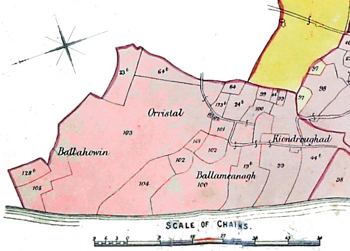
part of Plan of Michael - note orientation
[taken from Woods' Atlas and Gazatteer]
Full Table and Map is only on CD ROM
part of Plan of Michael - note orientation
| TREEN, &C. | NAME OF QUARTERLAND, or NO OF INTACK. |
NUMBER
ON PLAN. |
PROPRIETOR. |
EXTENT
IN STATUTE MEASURE. A. R. P. |
|---|---|---|---|---|
| ~~~~~~~~~~~~~~~~~~~~~~~ | ||||
| Orristal | Part of Kiondroghad |
13 3 22
|
||
|
24 2 28
|
||||
| " | Part of Kiondroghad |
44 T
|
Patrick Cannell | |
| " | Part of Ballameanagh |
30 3 13
|
||
| Intacks | No. 21, and part of 22 and 38 |
|
||
| " | Part of Nos. 23, 38, and all 24 |
99
|
John T. Callister |
1 0 6
|
| Orristal | Part of Kiondroghad |
20 3 23
|
||
| „ | Part of Orristal | |||
|
21 3 29
|
||||
| " | Part of Ballameanagh |
19 T
|
John Cain |
23 0 12
|
| Intack | Part of No. 23 | |||
| Orristal | Part of Ballameanagh |
100
|
Charles Cain |
33 0 16
|
| " | Part of Orristal | |||
| Intack | Part of No. 22, all 26 and 67 | |||
| " | No.25 | |||
| Orristal | Part of Orristal } |
24 T
|
John Cain |
3 3 19
|
| „ | ||||
| Intack | Part of Orristal |
101
|
Thomas Cannell |
5 2 2
|
| " | Part of No. 22 | |||
| Orristal | Part of Orristal |
102
|
John Cannell |
8 2 8
|
| „ | Ditto |
103
|
William Cannell |
0 1 15
|
| „ | Ditto |
104
|
Jane Cain |
17 026
|
| „ | Ditto |
173 T
|
John F. Crellin |
1 0 26
|
| " |
|
|||
| „ | Part of Orristal |
103 T
|
John F. Crellin |
22 2 33
|
| " | Part of Ballahowin | |||
| " | Part of Ballahowin |
82 1 13
|
||
|
105 0 6
|
||||
| " | Part of Ballahowin |
23 T
|
John F. Crellin |
10 1 6
|
| " | Ditto |
105
|
John Corgeage |
13 0 39
|
| " | Ditto |
128 T
|
John Cannell |
6 3 19½
|
| " | Ditto |
64 T
|
William Christian |
8 1 29
|
| Intack | No. 43 | |||
| Cottage | No. 9 |
106
|
Lord Bishop |
245 0 29
|
| Freehold | Part of Bishop's Demesne | |||
| Aryhorkill | Aryhorkill | |||
| Intacks | Nos. 2, 52, 55, 64, all of 42 |
107
|
Samuel Brook |
726 0 36
|
| Mill Rent. | (--) |
Total extent in statute measurement............................................5380 acres, 2 roods, and 18.75 perches.
|
|
||
|
|
Michael | |
|
|
||
|
Any comments, errors or omissions gratefully received The
Editor HTML Transcription © F.Coakley , 2010 |
||