[Note the large images are only available on CD_Rom]
|
|
|
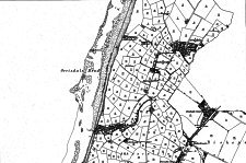
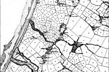
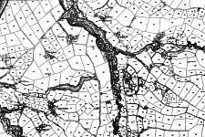
Note the 1:2500 sheets are numbered as a 4x4 subsheets of a 6"/1m sheet numbered from 1(top NW corner) to 16(bottom SE corner) - each sheet is 36" by 24" which thus covers 7500ft x 5000 ft.
The 6" sheets are not the same size or coverage as moder 6" sheets - neither are they on the same projection as current O/S maps (and obviously do not show the post WW2 Grid refs which are based on km squares - however the errors caused by projection changes are not significant over the coverage of a sheet. The SW corner of the lowest sheet would appear to be close to SC307887
My own collection of sheets is not complete (I have about 60% of all sheets) and is derived from various sources - a few are later electrotypes that show only one parish if a parish boundary is included on the sheet whereas the original full sheet would show both parishes - this can be seen in the top sheet in which Ballaugh parish has been 'erased' from the sheet (tho in this case I also have the other twin section)
The three sheets are from top IV 13, VII 1 and VII 5 - missing bits of the parish would be on IV 9, VI 8, VII 2, VII 6, VI 12, VII 9 and VII 10
See discussion re Ordnance Survey elsewhere
|
|
||
|
|
Michael | |
|
|
||
| Any comments, errors or omissions gratefully received
The Editor © F.Coakley, 2012 |
||